Earthquakes
S


Bizarro Earth

Vanuatu: Another Earthquake Magnitude 7.0

Vanuatu Quake_200811
© USGSEarthquake Location
Date-Time:
Saturday, August 20, 2011 at 18:19:24 UTC

Sunday, August 21, 2011 at 05:19:24 AM at epicenter

Time of Earthquake in other Time Zones

Location:
18.287°S, 168.132°E

Depth:
28.5 km (17.7 miles)

Region:
VANUATU

Distances:
69 km (42 miles) SSW of PORT-VILA, Efate, Vanuatu

177 km (109 miles) NW of Isangel, Tanna, Vanuatu

328 km (203 miles) SSE of Luganville, Espiritu Santo, Vanuatu

1853 km (1151 miles) ENE of BRISBANE, Queensland, Australia

Bizarro Earth

Vanuatu: Earthquake Magnitude 7.1

Image
© USGS
Date-Time:
Saturday, August 20, 2011 at 16:55:02 UTC

Sunday, August 21, 2011 at 03:55:02 AM at epicenter

Time of Earthquake in other Time Zones

Location:
18.259°S, 168.069°E

Depth:
40.6 km (25.2 miles)

Region:
VANUATU

Distances:
63 km (39 miles) SSW of PORT-VILA, Efate, Vanuatu

190 km (118 miles) NW of Isangel, Tanna, Vanuatu

316 km (196 miles) SSE of Luganville, Espiritu Santo, Vanuatu

1850 km (1149 miles) ENE of BRISBANE, Queensland, Australia

Bizarro Earth

Fiji Region - Earthquake Magnitude 6.2

Fiji Quake_190811
© USGSEarthquake Location
Date-Time
Friday, August 19, 2011 at 03:54:27 UTC

Friday, August 19, 2011 at 03:54:27 PM at epicenter

Time of Earthquake in other Time Zones

Location
16.526°S, 176.905°W

Depth
413.2 km (256.8 miles)

Region
FIJI REGION

Distances
283 km (175 miles) SSE of Sigave, Ile Futuna, Wallis and Futuna

343 km (213 miles) WSW of Hihifo, Tonga

370 km (229 miles) SSW of MATA'UTU, Ile Uvea, Wallis and Futuna

2396 km (1488 miles) NNE of Auckland, New Zealand

Bizarro Earth

Japan: Earthquake Magnitude 6.3 - East Coast of Honshu

Image
© USGS
Date-Time:
Friday, August 19, 2011 at 05:36:32 UTC

Friday, August 19, 2011 at 02:36:32 PM at epicenter

Time of Earthquake in other Time Zones

Location:
37.673°N, 141.716°E

Depth:
43.6 km (27.1 miles)

Region:
NEAR THE EAST COAST OF HONSHU, JAPAN

Distances:
99 km (61 miles) SE of Sendai, Honshu, Japan
103 km (64 miles) NE of Iwaki, Honshu, Japan
113 km (70 miles) E of Fukushima, Honshu, Japan
283 km (175 miles) NE of TOKYO, Japan

Bizarro Earth

US: Earthquake Magnitude 3.2 Strikes Long Beach and Los Angeles

Image
© Unknown
A Southern California earthquake today August 18, 2011 struck moments ago centered in Long Beach; the earthquake was felt over sections of Los Angeles and Orange Counties. Today's earthquake was of a marginal magnitude. But because it struck at a narrow depth, it was felt over a wide section of the South Bay and Southern California.

Ten minutes ago, at roughly 2:43 PM PST, a 3.2 earthquake struck Los Angeles County. Its epicenter was south east of Long Beach. Unlike previous earthquakes this year in the region, today's quake was not centered out in the Pacific Ocean.

Rather initial statements by USGS issued to news indicate that the quake was centered just a few blocks west of Pacific Coast Highway. Initial reports put the quake centered closest to the intersection of E7th Street and Park Avenue. It was centered apparently just north of the American Golf Pro Shops on the 9th Hole of the local Recreation Park Golf Course, near the East 7th street corridor.

Bizarro Earth

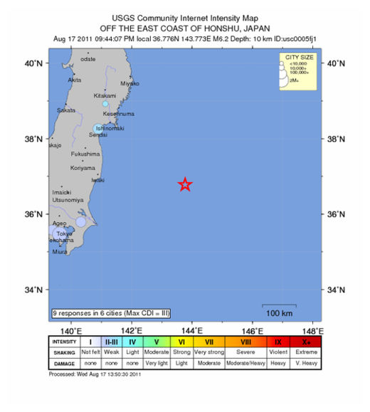
Off The Coast of Honshu, Japan - Earthquake Magnitutde 6.2

Honshu Quake_170811
© USGSEarthquake Location
Date-Time
Wednesday, August 17, 2011 at 11:44:07 UTC

Wednesday, August 17, 2011 at 09:44:07 PM at epicenter

Time of Earthquake in other Time Zones

Location
36.776°N, 143.773°E

Depth
10 km (6.2 miles) (poorly constrained)

Region
OFF THE EAST COAST OF HONSHU, JAPAN

Distances
304 km (188 miles) E of Iwaki, Honshu, Japan

339 km (210 miles) E of Mito, Honshu, Japan

349 km (216 miles) ESE of Sendai, Honshu, Japan

418 km (259 miles) ENE of TOKYO, Japan

Radar

Magnitude 4.3 Earthquake Rattles Crete, Greece

Image
The quake struck on Saturday, August 13, 2011 at 10:49:06 PM (CDT) - Central Daylight (Chicago).

Rumbling at a rather shallow depth of 10.2 km (6.3 miles), the quake hit 114 km (70 miles) SW of Chania, Crete, Greece; 195 km (121 miles) WSW of Iraklion, Crete, Greece; 259 km (160 miles) SSE of Kalamata, Greece; and 354 km (219 miles) S of ATHENS, Greece.

There are no reports of damage or tsunami activity.

Attention

Strong 6.0 Magnitude Earthquake Hits Philippine Island of Dalupiri, No Damage Reported

Image
© Google Maps
A strong earthquake struck the Philippine island of Dalupiri on late Thursday morning, seismologists said, but there were no immediate reports of damage or casualties.

The 6.0-magnitude earthquake at 10.56 a.m. local time (0256 GMT) was centered less than a kilometer (mile) from the western coast of Dalupiri Island, which is part of the Babuyan Islands in the Luzon Strait north of Luzon island in the Philippines. It struck about 113 kilometers (70 miles) deep, making it an earthquake of intermediate depth, according to the Philippine Institute of Volcanology and Seismology (PHIVOLCS).

There were no immediate reports of damage or casualties from the area, which is mostly uninhabited. The United States Geological Survey (USGS) measured the earthquake at only 5.4 on the Richter scale but at a much shallower depth of just 20 kilometers (12 miles).

The Philippines is on the so-called 'Pacific Ring of Fire', an arc of fault lines circling the Pacific Basin which is prone to frequent and large earthquakes. Volcanic eruptions also occur frequently in the region.

Radar

4.1 Magnitude Earthquake Recorded Near US-Mexico Border

Image
© Epicentre. Image Google Maps
A magnitude 4.1 struck close to Baja California's (Mexico) border with the U.S. state of California on Tuesday evening, according to the US Geological Survey (USGS).

The quake hit 40 kilometres from the border and was centred 34 km (21 miles) NE (44°) from Ensenada, 45 km (28 miles) NNE (25°) from Maneadero, 59 km (36 miles) SSE (155°) from Tecate, and 78 km (49 miles) SE (128°) from Tijuana (all Baja California, Mexico).

The earthquake was recorded at a shallow depth of 11.3 km (7.0 miles). It was followed six hours later by a magnitude 2.6 earth tremor.

USGS information on earthquake HERE

Attention

Pakistan: Magnitude 5.7 Earthquake Recorded in Parts of Karachi

Seismological Network of Pakistan Meteorological Department has recorded an earthquake, with a magnitude of 5.7 in some parts of Karachi on Wednesday morning. The epic center of the quake was a site near Kharan, in Balochistan, said a Met Department's press release. Jolts were also felt in Balochistan, with depth of earthquake registered to be 45.Km at 27.82 latitude towards North and 65.17E longitude towards East.