Earth ChangesS


Bizarro Earth

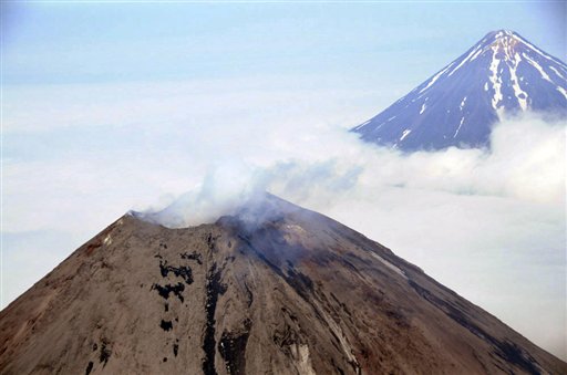
Dome grows in Alaska's Cleveland Volcano

Cleveland Volcano
© AP Photo/NOAA, Kym YanoThis Monday, Aug. 8, 2011 file aerial photo provided by the National Oceanic and Atmospheric Administration shows Cleveland Volcano, left, located in the Aleutian Islands 939 miles southwest of Anchorage, Alaska. The volcano, which has sent up major ash eruptions in the past, is heating up near its summit. Scientists at the Alaska Volcano Observatory say satellite data obtained a week ago indicates a lava dome is growing in the summit crater. The observatory has changed its alert level for aircraft.
Anchorage, Alaska - Alaska's Cleveland Volcano is heating up and scientists are on alert in case it sends up an ash cloud that could threaten trans-Pacific flights.

The Alaska Volcano Observatory detected elevated surface temperatures Jan. 24 at Cleveland's summit. Satellite data obtained last week indicated that a growing lava dome on the floor of the summit crater had reached about 328 feet, or 100 meters, in diameter.

The summit crater itself is nearly 10 times that size, said Chris Waythomas of the U.S. Geological Survey.

"It does this from time to time and it's a fairly small lava dome," he said Wednesday. "It's not gigantic."

Lava domes form a lid on a volcano chamber that holds magma. When they grow big enough, lava domes can become unstable and collapse. Decompression of the magma chamber can lead to an explosion as the conduit inside the volcano suddenly becomes unsealed and gasses escape.

Bizarro Earth

What caused the Solomon Islands earthquake & tsunami?

Solomon Quake
© U.S. Geological SurveyA map showing the intensity of shaking caused by a magnitude 8.0 earthquake in the Solomon Islands.
The deadly earthquake and tsunami that hit the Solomon Islands today struck along a subduction zone, the same geologic setting responsible for the world's most powerful earthquakes.

In a subduction zone, two of Earth's tectonic plates meet and one slides beneath the other into the mantle, the deeper layer beneath the crust. The Solomon Islands sit above the collision between the Australia and Pacific plates. In the region of today's magnitude-8.0 earthquake, the Australia plates dives beneath the Pacific plate toward the east-northeast at a geologically speedy 3.7 inches (94 millimeters) per year, according to the Incorporated Research Institutions for Seismology (IRIS).

The earthquake hit at a depth of 17.8 miles (28.7 kilometers) and was the second-largest earthquake in the Solomon Islands region in almost 40 years, IRIS said in a statement. Several aftershocks followed; the largest measured magnitude 6.6, according to the U.S. Geological Survey (USGS).

The tsunami generated by the quake, reported as 3 feet (0.9 meters) in height, hit villages on Santa Cruz Island, destroying structures and homes, according to news reports. A tsunami watch was issued for Australia, Indonesia and New Zealand, but not for the rest of the Pacific, according to the West Coast and Alaska Tsunami Warning Center.

Bizarro Earth

USGS: Earthquake Magnitude 7.0 - 27km NNW of Lata, Solomon Islands

Image
© USGS
Event Time:
2013-02-06 01:54:15 UTC
2013-02-06 12:54:15 UTC+11:00 at epicenter

Location:
10.479°S 165.772°E depth=9.8km (6.1mi)

Nearby Cities:
27km (17mi) NNW of Lata, Solomon Islands
579km (360mi) NNW of Luganville, Vanuatu
648km (403mi) E of Honiara, Solomon Islands
848km (527mi) NNW of Port-Vila, Vanuatu
1166km (725mi) N of We, New Caledonia

Arrow Up

Food prices: More increases ahead for U.S. consumers

Image
Iowa farmers remained resilient through last year's drought, but the same can't be said for food prices.

The USDA says consumers will begin to see more of an impact from the drought at the grocery store.

Snowflake

Powerful storm to dump foot of snow this weekend on U.S. East Coast as region braces for coastal storm

A powerful coastal storm could dump as much as a foot of snow on areas of the East Coast this weekend. Though metropolitan areas along the East Coast have enjoyed a relatively mild winter with less than half of the average snowfall, a mix of snow, wind, and rain could change all of that come Friday and Saturday. Meteorologists say that a weather system from the Midwest will meet with one from the South, creating a storm that will deliver wind, snow, and rain.

The Weather Channel reports that the Midwestern storm pattern, which passed through Chicago and Milwaukee, will mix with wetter weather coming from New Orleans, Louisville, and even Atlanta. By Thursday night, forecasts predict that the clipper system will travel from the Great Lakes region to the East Coast, passing through cities like Philadelphia, New York, and up towards Boston.
Image

Blue Planet

Small tsunami hits Solomons after major quake

Image
© Hugh Gentry/ReutersThe Pacific Tsunami Warning Centre in Hawaii has issued an alert after a quake off the Solomon Islands.
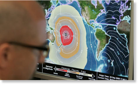
Sydney - A small tsunami hit the Solomon Islands on Wednesday after a major 8.0 magnitude undersea earthquake sparked a tsunami warning for several South Pacific island nations and placed many more nations including Australia and Indonesia on alert.

The quake struck at a very shallow depth of only five km (three miles) and was located 340 km (211 miles) east of Kira Kira in the Solomons, the Pacific Tsunami Warning Center in Hawaii said.

The center said a tsunami measuring 0.9 metres (three feet) hit the Solomons following the quake.

The Solomon Islands Broadcasting Corporation cited a witness who said water was covering an airstrip in Lata, in Temotu province, but there were no immediate reports of damage or casualties.

Solomon Islands police in the small town of Kira Kira, on San Chrostobal island, said they felt the quake, but there were no reports of any damage from the quake or a tsunami.

"We felt the shock. We have warned people to get to higher ground," said local police officer Samuel Tora.

The tsunami warning center gave arrival times from a few minutes to several hours to island nations around the South Pacific.

The warning was issued for the Solomon Islands, Vanuatu, Nauru, Papua New Guinea, Tuvalu, New Caledonia, Kosrae, Fiji, Kiribati, and Wallis and Futuna islands.

Ice Cube

Snowiest winter in 100 years paralyzes Moscow

Image
© RIA Novosti / Denis Tyrin
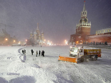
The snowiest winter in a century has hit the Russian capital, causing Muscovites to get stuck in traffic jams 3,500km in length on Monday evening - the distance from Moscow to Madrid.

­Since the beginning of the winter, over 2 meters of snow has fallen on the Russian capital, the Moscow mayor's aide in housing and public utilities Pyotr Biryukov told Interfax. Snowfall is expected in Moscow for four or five more days, he added.

On Monday, 45,000 community services employees and 15,000 units of equipment were attempting to cope with 26 cm of snow - nearly a fifth of the average annual fall.

The latest snowfall has become a nightmare for drivers with the capital's commuters trapped in gridlock.

Many of those who left their workplace in the evening had to spend five to 10 hours getting home. The average speed of vehicles was no more than 7-9 km/h. The number of road accidents - 3,000 - was much higher than during an ordinary day, with minor accidents quadrupling, according to Channel One TV.

Bizarro Earth

Tsunami warning issued after 8.0 earthquake in the South Pacific

Tsunami Warning Sign
© CTV News Canada
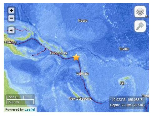
A tsunami warning has been issued for a vast region in the South Pacific after an 8.0-magnitude earthquake struck near the Santa Cruz Islands.The earthquake was recorded at a depth of 33 kilometres below the ocean's surface.

The tsunami warning is in effect for a number of South Pacific islands, including Solomon Islands, Vanuatu, Fiji and Papua New Guinea.A tsunami watch is in effect for Australia, New Zealand, Indonesia and a number of islands further away from the epicentre.

Link to updated tsunami watch

More to come...

Bizarro Earth

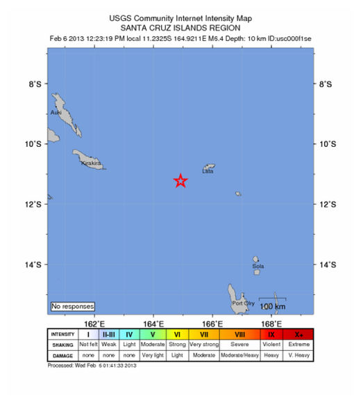
USGS: Aftershock Magnitude 6.4 - Santa Cruz Islands Region

2nd Santa Cruz Islands Quake_060213
© USGS
Event Time
2013-02-06 01:23:19 UTC

Location
11.232°S 164.921°E depth=10.1km (6.3mi)

Technical Details

Bizarro Earth

USGS: Earthquake Magnitude 8.0 - Santa Cruz Islands

Santa Cruz Islands Quake_060213
© USGS
Event Time
2013-02-06 01:12:27 UTC

Location
10.752°S 165.089°E depth=5.8km (3.6mi)

Technical Details