Earthquakes
S


Bizarro Earth

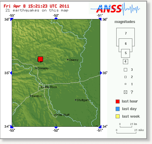
US: Earthquake Magnitude 4.2 - Arkansas

Image
© USGS
Date-Time:
Friday, April 08, 2011 at 14:56:32 UTC

Friday, April 08, 2011 at 09:56:32 AM at epicenter

Location:
35.261°N, 92.362°W

Depth:
6.3 km (3.9 miles)

Region:
ARKANSAS

Distances:
4 km (3 miles) NE (34°) from Greenbrier, AR

8 km (5 miles) SE (138°) from Twin Groves, AR

8 km (5 miles) SSW (200°) from Guy, AR

21 km (13 miles) NNE (23°) from Conway, AR

58 km (36 miles) N (357°) from Little Rock, AR

419 km (260 miles) SSW (207°) from St. Louis, MO
Bizarro Earth

Japan: New Earthquake Brings Tsunami Warning

A powerful earthquake off the northeast coast of Japan shook a large area late Thursday. The jolt appeared to be an aftershock from the catastrophic earthquake and tsunami that hit Japan nearly four weeks ago.

The earthquake generated a tsunami warning, and Japan's NHK television immediately warned residents in the area to move to higher ground, but there were no immediate reports of major disruptions in the ocean.

The earthquake and tsunami alert raised fears about possible effects at the damaged Fukushima nuclear reactor, which has been leaking radio since the original earthquake.

The Tokyo Electric Power Company said it had no reports of any new damage or casualties near the reactor site caused by Thursday's earthquake, which hit shortly before midnight (at 1432 UTC). The aftershock was initially recorded at magnitude 7.4, but the U.S. Geological Survey later downgraded the jolt to magnitude 7.1 - still a powerful earthquake overall, but far less dangerous than the 9.0-magnitude shock on March 11.

Speaking at a news conference, a TEPCO official said water-pumping operations were continuing to keep the nuclear plant's fuel rods from overheating to a dangerous degree. Workers at the plant have been struggling to bring the nuclear reactors under control for the past three weeks.

Bad Guys

Updated: Japan - Earthquake Magnitude 7.1 - Honshu

Image
© USGS
Date-Time:
Thursday, April 07, 2011 at 14:32:41 UTC

Thursday, April 07, 2011 at 11:32:41 PM at epicenter

Time of Earthquake in other Time Zones

Location:
38.253°N, 141.640°E

Depth:
25.6 km (15.9 miles)

Region:
NEAR THE EAST COAST OF HONSHU, JAPAN

Distances:
66 km (41 miles) E of Sendai, Honshu, Japan

114 km (70 miles) E of Yamagata, Honshu, Japan

116 km (72 miles) ENE of Fukushima, Honshu, Japan

330 km (205 miles) NNE of TOKYO, Japan

Bizarro Earth

Mexico: Earthquake Magnitude 6.5 - Veracruz

Image
© USGS
Date-Time:
Thursday, April 07, 2011 at 13:11:24 UTC
Thursday, April 07, 2011 at 08:11:24 AM at epicenter
Time of Earthquake in other Time Zones

Location:
17.431°N, 93.978°W

Depth:
167.4 km (104.0 miles)

Region:
VERACRUZ, MEXICO

Distances:
91 km (56 miles) SSE of Coatzacoalcos, Veracruz, Mexico

118 km (73 miles) NW of Tuxtla Gutierrez, Chiapas, Mexico

127 km (78 miles) WSW of Villahermosa, Tabasco, Mexico

590 km (366 miles) ESE of MEXICO CITY, D.F., Mexico

Bizarro Earth

Volcanic quakes recorded at Taal, Bulusan; crater glow at Mayon

Image
© Unknown
Restive Taal Volcano continued to show signs of activity, as state volcanologists recorded at least five volcanic quakes there in the last 24 hours.

The Philippine Institute of Volcanology and Seismology (Phivolcs) on Wednesday said it also observed weak steaming activity at the thermal area of the main crater-lake.

Phivolcs also reiterated its warning against carbon dioxide in the area, saying gas measurements in March amounted to 4,670 tons per day - double the 2,250 tons per day in January.

"The remarkable increase in C02 [Carbon dioxide] concentration indicates anomalous gas release from the magma at depth," it said.

It added Alert Level 1 remains over Taal Volcano, saying no eruption is imminent but the public should strictly observe some safety precautions.

Phivolcs said the main crater should remain strictly off-limits because sudden hazardous steam-driven explosions may occur and high concentrations of toxic gases may accumulate.

Bizarro Earth

Indonesia - Earthquake Magnitude 6.0 - Kepulauan Talaud

Indon Quake_050411
© USGSEarthquake Location
Date-Time:
Tuesday, April 05, 2011 at 11:14:15 UTC

Tuesday, April 05, 2011 at 07:14:15 PM at epicenter

Time of Earthquake in other Time Zones

Location:
3.061°N, 126.973°E

Depth:
17.6 km (10.9 miles)

Region:
KEPULAUAN TALAUD, INDONESIA

Distances:
256 km (159 miles) N of Ternate, Moluccas, Indonesia

292 km (181 miles) NE of Manado, Sulawesi, Indonesia

959 km (595 miles) WSW of KOROR, Palau

1436 km (892 miles) SSE of MANILA, Philippines

Bizarro Earth

7.1-magnitude quake strikes off Indonesian island, tsunami warning issued

Jakarta -- A powerful earthquake struck off the Indonesian island of Java on early Monday morning, seismologists said, prompting a tsunami warning for some local regions.

The 7.1-magnitude earthquake at 3.06 a.m. local time (2006 GMT Sunday) was centered about 279 kilometers (173 miles) south-southwest of Tasikmalaya on Java. It struck about 10 kilometers (6.2 miles) deep, making it a shallow earthquake, according to Indonesia's seismological agency.

Authorities in Indonesia immediately issued a tsunami warning for some coastal areas, while the Pacific Tsunami Warning Center said there was no threat of a Pacific-wide tsunami.

Bizarro Earth

Indonesia - Earthquake Magnitude 6.7 - South of Java

Indon Quake_030411
© USGSEarthquake Location
Date-Time:
Sunday, April 03, 2011 at 20:06:42 UTC

Monday, April 04, 2011 at 03:06:42 AM at epicenter

Time of Earthquake in other Time Zones

Location:
9.786°S, 107.749°E

Depth:
24 km (14.9 miles)

Region:
SOUTH OF JAVA, INDONESIA

Distances:
241 km (149 miles) ENE of Christmas Island

277 km (172 miles) S of Tasikmalaya, Java, Indonesia

318 km (197 miles) S of Bandung, Java, Indonesia

412 km (256 miles) SSE of JAKARTA, Java, Indonesia

Bizarro Earth

Earthquake Magnitude 6.4 - Fiji Region

Fiji Quake_030411
© USGSEarthquake Location
Date-Time:
Sunday, April 03, 2011 at 14:07:09 UTC

Monday, April 04, 2011 at 02:07:09 AM at epicenter

Time of Earthquake in other Time Zones

Location:
17.649°S, 178.578°W

Depth:
551.9 km (343.0 miles) set by location program

Region:
FIJI REGION

Distances:
252 km (156 miles) W of Lambasa, Vanua Levu, Fiji

321 km (199 miles) W of SUVA, Viti Levu, Fiji

335 km (208 miles) N of Ndoi Island, Fiji

2230 km (1385 miles) W of Auckland, New Zealand

Bizarro Earth

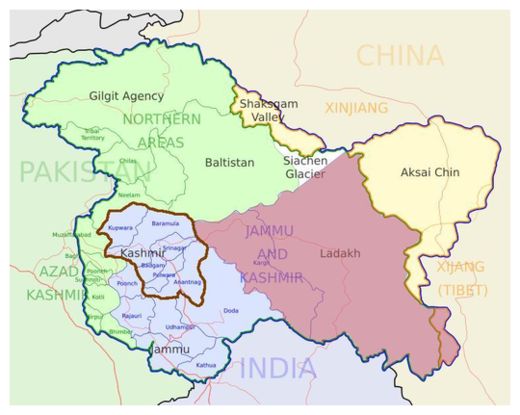
Kashmir: Sixth Tremor Hits Valley in 11-days

Kashmir Valley
© Opus88888 / WikipediaMarking the three regions of the Indian state of Jammu and Kashmir: Jammu, Kashmir valley and Ladakh.
Srinagar - A moderate intensity earthquake, sixth within a span of 11 days, was felt in Kashmir Valley on Saturday morning.

The Coordinator of Disaster Management Cell Kashmir, Aamir Ali said that an earthquake of magnitude 4.7 on Richter scale occurred at 0924 hours.

The jolt was epicentred in Xinjiang border in Ladakh-China at 36.5 degree north latitude and 70.9 degree east longitude, Aamir said in a statement.

The tremor follows one on previous night at 1900 hours when an earthquake of magnitude 4.9 was felt with epicentre at Hindukush Afghanistan at 36.54 N, 70.91E, the he said, adding that no damage was reported from any part of the Valley.