Earthquakes
S


Seismograph

A strong 6.5-magnitude earthquake in the Pacific Ocean shakes Central America

mmmmm
A powerful 6.5 magnitude earthquake in the Pacific Ocean off the coast of El Salvador shook much of Central America from Nicaragua to Guatemala on Tuesday, sending residents in some cities streaming into the streets.

The U.S. Geological Survey reported the epicenter was 27 miles (43 kilometers) south of Intipuca, El Salvador at a depth of 43 miles (70 kilometers). That point is outside the Gulf of Fonseca where Honduras, El Salvador and Nicaragua all share coastline.

In El Salvador's capital, residents ran into the streets as the ground shook, but there were no immediate reports of damage or injuries. When a radio station open its phone lines to residents around the country, there was also no immediate report of victims.


Seismograph

Magnitude 6.6 earthquake strikes in Argentina and is felt in neighboring Chile, but no damage reported

mmmmm
A magnitude 6.6 earthquake struck deep in the Earth under Argentina on Sunday and was felt in neighboring Chile, but authorities didn't report any damage.

The quake occurred at a depth of 171 kilometers (106 miles), according to the U.S. Geological Survey. The epicenter was in the province of Neuquen, in western Argentina, 25 kilometers (15.5 miles) east-southeast of the town of Loncopue.

The earthquake was felt in the central and southern parts of neighboring Chile. Neither Argentine nor Chilean authorities reported any damages.


The Associated Press

Seismograph

Shallow 7.2 magnitude earthquake hits Alaska coast as tsunami warning issued

NNNNNNNN
An earthquake of magnitude 7.2 struck the Alaska Peninsula region early on Sunday morning, with a tsunami warning issued.

According to the United States Geological Survey (USGS), the quake occurred at depth of 9.3km (5.78 miles) and was relatively shallow.

The U.S. Tsunami Warning System issued a tsunami warning for regions of the Pacific located close to the earthquake.

The Alaska Earthquake Centre said the event was felt widely throughout the Aleutian Islands, the Alaskan Peninsula, and Cook Inlet regions.

In a statement, the National Tsunami Warning Center said: "Tsunami warning in effect for South Alaska and the Alaska Peninsula, Pacific coasts from Kennedy Entrance, Alaska (40 miles SW of Homer) to Unman Pass, Alaska (80 miles NE of Unalaska).

Seismograph

Magnitude 6.3 earthquake occurs off the coast of Chiapas State, Mexico

MMMMMM
A magnitude-6.3 earthquake occurred in the Pacific Ocean off the coast of Chiapas State at around 03:29 July 14. The epicenter was about 88 km (54 miles) southwest of El Palmarcito. The tremor occurred at a depth of about 35 km (22 miles), and moderate-to-light shaking was probably felt in some coastal areas of Chiapas, as well as light-to-weak shaking throughout parts of central, southern, and western Chiapas, eastern Oaxaca, and far southeastern Veracruz states in Mexico and into southeastern Guatemala.

There have been no initial reports of damage or casualties as a result of the earthquake; however, significant damage is unlikely due to the offshore nature of the quake. It could take several hours until authorities can conduct comprehensive damage assessments, especially in remote areas. Moderate-to-light aftershocks are likely over the coming days. The event has not prompted any tsunami advisories.

Seismograph

Shallow 6.6 magnitude earthquake strikes in the Atlantic Ocean near the northern Caribbean

mmmm
A 6.6 magnitude earthquake struck Monday in the Atlantic Ocean near the northern Caribbean, causing some buildings to lightly sway in the region.

The quake struck at a shallow depth of six miles (10 kilometers), according to the U.S. Geological Survey. The epicenter was located about 170 miles (270 kilometers) north-northeast of Antigua and Barbuda.

The earthquake was felt on several islands, including Puerto Rico. No damage was immediately reported.

Source: AP

Attention

4,700 earthquakes in 72 hours could signal impending eruption of Icelandic volcano

Earthquakes around the Fagradalsfjall volcano
© Fox WeatherEarthquakes around the Fagradalsfjall volcano
Residents on the Nordic island nation of Iceland are closely watching a volcano that has been the focal point of thousands of earthquakes over the last few days, which could signal an upcoming eruption.

The Icelandic Meteorological Office reports more than 4,700 earthquakes have occurred around Mount Fagradalsfjall - an active volcano about an hour's drive from the capital city of Reykjavík.

Most earthquakes have been minor, but government agencies warn that seismic activity has increased the risk of landslides.

Alert statuses around the volcano have been raised in anticipation of increased activity and volcanic ash.

The volcano produced a series of eruption events in 2021 and 2022 but has been mostly quiet for nearly a year.

Seismograph

Magnitude 6.9 earthquake strikes near Neiafu, Tonga

mmmm
An earthquake of magnitude 6.9 struck the Neiafu region in Tonga on Sunday, the United States Geological Survey said.

There was no tsunami danger for the US West Coast, British Columbia and Alaska, The US Tsunami Warning System said.

The quake was at a depth of 247 km (153.48 miles), the USGS said.

By Reuters

Attention

Strong earthquake swarm at Katla volcano in Iceland - 58 quakes and counting

katla volcano
© Icelandic Met OfficeOngoing earthquake activity in Katla volcano.
During the night of 30. June 2023 an earthquake swarm started in Katla volcano. At the writing of this article the largest verified earthquake had a magnitude of Mw3,3.

This earthquake swarm is ongoing at the writing of this article. Currently an eruption has not started, if that is going to change is something that just has to show it self in next few hours if this earthquake activity continues to increase. All that can be done for now is to monitor this situation.

Comment: One reader writes:
The swarm is situated in a fairly unusual spot, compared to earlier unrest. We have been used to seeing EQ activity closer to the northern rim of the caldera (closer to AUS station), not often in the center of it. This could evolve into a new, interesting chapter for Katla.
More interesting details from youtuber Oppenheimer Ranch:

See also: 'One day it will just go off': are Naples' volcanic craters at Campi Flegrei about to blow?


Info

The mysterious case of Ireland's missing earthquakes

The Emerald Isle has far fewer earthquakes than neighboring Britain. Now scientists think they know why.
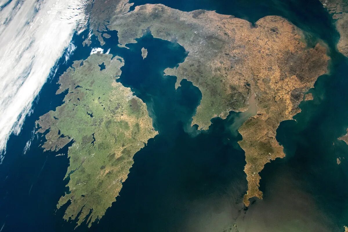
Ireland and Britain
© NASAIreland and Britain sit thousands of kilometers from the nearest tectonic plate boundary and just a few dozen from each other, yet Britain experiences far more earthquakes than Ireland.
Ireland and Britain should be, seismologically speaking, equally boring. The two islands lie thousands of kilometers from the nearest plate boundary and are not volcanic hot spots. But though the ground rarely rumbles in Ireland, neighboring Britain experiences plenty of weak and moderate earthquakes.

The lithosphere — Earth's outermost rocky veneer, which includes the crust and the solid upper mantle — is thicker and cooler beneath Ireland than it is beneath Britain, new research has suggested. Cool, thick lithosphere is mechanically stronger than warm, thin lithosphere, which could explain the Emerald Isle's puzzling paucity of earthquakes. The new results, published in Geophysical Journal International, hinted that lithosphere thickness could underpin patterns in seismic activity in other places far from plate boundaries.

Seismograph

Shallow 6.0-magnitude quake hits south of Tonga: USGS

mmmmmmm
An earthquake with a magnitude of 6.0 jolted south of Tonga at 07:16:59 GMT on Sunday, the U.S. Geological Survey said.

The epicenter, with a depth of 7.087 km, was initially determined to be at 24.0318 degrees south latitude and 175.6262 degrees west longitude.