Earthquakes
S


Bizarro Earth

Friday's 5.1 quake in Los Angeles renews seismologists' fears of catastrophic quake on dangerous Puente Hills fault

Image
© Reuters / Gene BlevinsBroken bottles are seen on the floor after falling off the shelves at a CVS pharmacy, following a magnitude 5.1 earthquake in Fullerton, California March 29, 2014. (
The magnitude-5.1 earthquake that rattled Southern California on Friday was a 10-second reminder of a fault that seismologists believe can produce a catastrophic disaster.

The Puente Hills thrust fault is so dangerous because of its location, running from the suburbs of northern Orange County, though the San Gabriel Valley and under the skyscrapers of downtown Los Angeles before ending in Hollywood.

Experts say a major 7.5-magnitude earthquake on the fault could do more damage to the heart of Los Angeles than the dreaded Big One on the San Andreas fault, which is located on the outskirts of metropolitan Southern California.

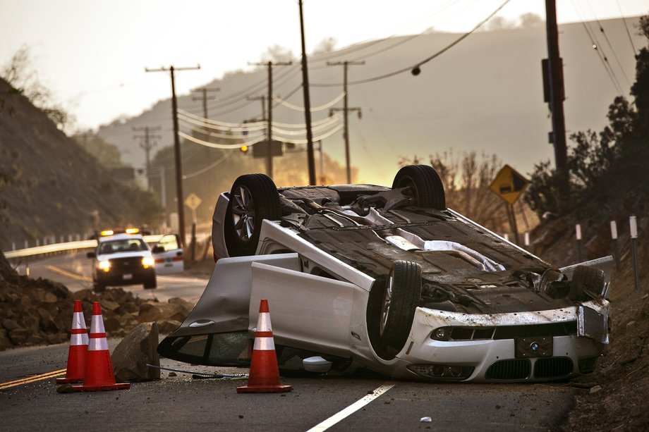
The size of Friday's quake was considered moderate, but it packed a punch. Residents within 10 miles of the epicenter in La Habra reported toppled furniture, broken glass and fallen picture frames. Several water mains broke, and a rockslide in Carbon Canyon caused a car to overturn, leaving those inside with minor injuries.

Officials said more than a dozen homes were red-tagged because of possible structural damage.
Alarm Clock

Yellowstone Bison filmed running along road in Yellowstone Park

Animals can often sense trouble long before humans. These Bison are coming down the hills in droves and fleeing on the road to get away from Yellowstone. Is the volcano there going to erupt?


Comment: 4.8 magnitude earthquake in Yellowstone National Park


Attention

4.8 magnitude earthquake in Yellowstone National Park


YELLOWSTONE VOLCANO OBSERVATORY INFORMATION STATEMENT

Sunday, March 30, 2014 10:31 AM (Sunday, March 30, 2014 16:31 UTC)

YELLOWSTONE VOLCANO (VNUM #325010)
44°25'48" N 110°40'12" W, Summit Elevation 9203 ft (2805 m)
Current Volcano Alert Level: NORMAL
Current Aviation Color Code: GREEN

The University of Utah, a YVO member agency, sent out the following press release about a magnitude 4.8 earthquake that occurred this morning at 6:34 AM MDT.

PRESS RELEASE
University of Utah Seismograph Stations
Released: March 30, 2014 08:15 AM MDT

The University of Utah Seismograph Stations reports that a light earthquake occurred at 06:34 AM on March 30, 2014 (MDT). The epicenter of the magnitude 4.8 shock was located 4 miles north-northeast of Norris Geyser Basin in Yellowstone National Park, Wyoming. This earthquake is part of a series of earthquakes that began in this area on Thursday, March 27. As of 8:15 am today, this series has included at least 25 earthquakes in addition to the main shock, with the largest of magnitude 3.1. The magnitude 4.8 main shock was reported felt in Yellowstone National Park and in the towns of West
Yellowstone and Gardiner, Montana.

Anyone who felt the earthquake is encouraged to fill out a survey form on either the Seismograph stations web site: www.quake.utah.edu or the U.S. Geological Survey web site: earthquake.usgs.gov.

Attention

Earthquake: 4.1 strikes near Rowland Heights CA; felt over wide area

Image
© Irfan Khan/LA TimesCaltrans workers and Brea police officers inspect a BMW that was overturned in a rock slide in Carbon Canyon after a magnitude 5.1 earthquake.
A shallow magnitude 4.1 earthquake was reported Saturday afternoon one mile from Rowland Heights, according to the U.S. Geological Survey. The temblor occurred at 2:32 p.m. at a depth of 5.6 miles. (It was originally reported as a 4.4 magnitude.)

Updated at 2:40 p.m.

The quake was centered not far from the epicenter of Friday's 5.1 temblor in La Habra. There have been more than a hundred aftershocks since then, but this one was the largest.

Saturday's quake was felt across a large area of Southern California. There were no immediate reports of damage or injuries.

Across Northern Orange County, officials were tallying moderate damage from Friday's quake. Much of the damage was in La Habra, Fullerton and Brea.

Bizarro Earth

Recent earthquake in Los Angeles a warning that California overdue for a big earthquake?

earthquakes
© Associated Press File
Was the recent earthquake in Los Angeles a warning of more to come? 'Earthquake Storms' author John Dvorak shares his thoughts.

On March 17, a mild earthquake rattled countless Los Angeles-area residents awake shortly before their alarms went off at 6:30 a.m. The Monday morning temblor was the first notable L.A.-area quake in years.

A lengthy vacation from earthquakes certainly sounds nice. But John Dvorak, a geophysicist who now works at a astronomical observatory in Hawaii, warns that a quake break can just be the calm before the earthquake storm.

He makes his case that the Golden State is in for trouble in his readable and aptly named new book "Earthquake Storms: The Fascinating History and Volatile Future of the San Andreas Fault."

But it's not just Californians who should pay attention to his exploration of earthquake science, the unfolding mysteries of geology, and the gaps in our seismic knowledge.

As he notes in an interview, plenty of other parts of the country are vulnerable to earthquakes, including the Northwest, the Midwest, the South and - yes - even the Big Apple.

Comment: Southern California just experienced another earthquake this week and the ring of fire has been quite active recently:
USGS: Earthquake Magnitude 5.1 - 1km S of La Habra, California
Ring Of Fire: It Is Roaring To Life And There Will Be Earthquakes Of Historic Importance On The West Coast Of The United States


Bizarro Earth

USGS: Earthquake Magnitude 5.1 - 1km S of La Habra, California

Image
© dpa
Event Time:
2014-03-29 04:09:42 UTC
2014-03-28 21:09:42 UTC-07:00 at epicenter

Location:
33.919°N 117.944°W depth=7.5km (4.6mi)

Nearby Cities:
1km (1mi) S of La Habra, California
4km (2mi) W of Brea, California
5km (3mi) NNW of Fullerton, California
6km (4mi) E of La Mirada, California
546km (339mi) W of Phoenix, Arizona

Comment: The ring of fire seems to be active, especially in this month. Just click play to get an overview with the "Sott worldview" of earthquakes and volcanoes just for March:


Bizarro Earth

5.1 magnitude earthquake felt in Los Angeles and region: Minor injuries, homes damaged

A magnitude 5.1 earthquake was reported Friday evening one mile from La Habra, California, according to the U.S. Geological Survey. The temblor occurred at 9:09 p.m. Pacific time at a depth of 0.6 miles.
Image
© dpa
11:50 p.m.

USGS scientist Lucy Jones' advice for Friday night: "Don't put your child to bed under a tall bookcase that could fall over him tonight."

Updated at 11:30 p.m.

Fullerton police say the corner of Rosecrans and Gilbert avenues is closed because of a water main break.

Updated at 11:28 p.m.

Southern California Edison says about 3,000 customers are without power.

Comment: The ring of fire seems to be active, especially in this month. Just click play to get an overview with the "Sott worldview" of earthquakes and volcanoes just for March:


Bizarro Earth

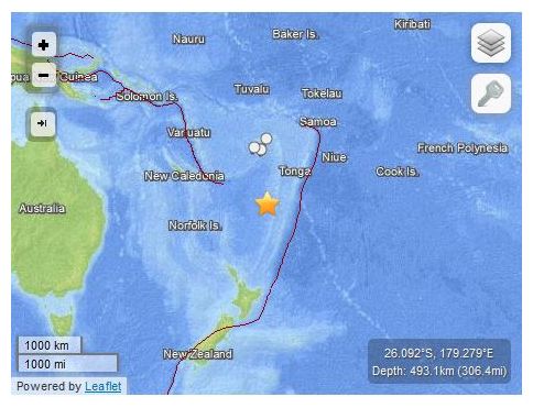
USGS: Earthquake Magnitude 6.5 - South of the Fiji Islands

Fiji Quake_260314
© USGS
Event Time
2014-03-26 03:29:36 UTC
2014-03-26 15:29:36 UTC+12:00 at epicenter

Location
26.092°S 179.279°E depth=493.1km (306.4mi)

Nearby Cities
448km (278mi) NW of Raoul Island, New Zealand
786km (488mi) SW of Nuku'alofa, Tonga
884km (549mi) S of Suva, Fiji
938km (583mi) SSE of Nadi, Fiji
1071km (665mi) S of Lambasa, Fiji

Technical Details

Alarm Clock

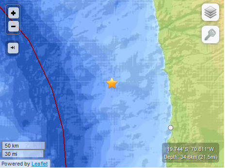
USGS: Earthquake magnitude 6.0 - 87km NW of Iquique, Chile

Earthquake 6.0  Chile
© USGS
Event Time
2014-03-23 18:20:03 UTC
2014-03-23 13:20:03 UTC-05:00 at epicenter
2014-03-23 19:20:03 UTC+01:00 system time

Location

19.744°S 70.811°W depth=34.6km (21.5mi)

Nearby Cities
87km (54mi) NW of Iquique, Chile
150km (93mi) SSW of Arica, Chile
201km (125mi) SSW of Tacna, Peru
239km (149mi) SSE of Ilo, Peru
456km (283mi) SW of La Paz, Bolivia

Technical data

Chart Bar

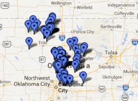
Fracking: 14 earthquakes recorded in Oklahoma since Friday

Image
© Leonard Observatory/Google MapsQuakes this year in Oklahoma
The U.S. Geological Survey has recorded 14 earthquakes in Oklahoma since about 9:30 p.m. Friday, the largest being a magnitude 4.0.

The 4.0 magnitude quake was recorded at 10:05 p.m. Friday about seven miles south of Langston. Three other quakes of magnitude 2.9, 3.0 and 3.3 were recorded Saturday afternoon in the Medford area.

The other quakes ranged from magnitude 2.4 to 2.9. No injuries or damage are reported.

Geologists say earthquakes of magnitude 2.5 to 3.0 are generally the smallest felt by humans.