Earthquakes
S


Radar

US: Powerful 5.8 Magnitude Shallow Earthquake Hits Gulf Of California

Image
© Google Earth
The Gulf of California, a body of water that separates the Baja California Peninsula from the Mexican mainland, was struck by a powerful shallow earthquake Tuesday morning.

The 5.8 magnitude quake struck at 11.44a.m. local time. The epicentre was situated 86 km (53 miles) southwest of Los Mochis, Sinaloa; 138 km (85 miles) north-northeast of La Paz, Baja California Sur; and 142 km (88 miles) west-southwest of Guamuchil, Sinaloa (Mexico).

The US Geological Survey (USGS) measured the seaquake depth at a shallow 10.2 kilometres (6.3 miles).

Radar

More aftershocks hit Japan as radiation is picked up in Glasgow, Scotland

Image
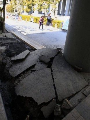
© AP Photo/Lee Jin-man via PA ImagesPeople walk past a damaged road outside of Tokyo Disneyland in Urayasu, east of Tokyo, Japan, Tuesday, March 29, 2011. Tokyo Disneyland was shut down after the March 11 earthquake and has been closed ever since.
A number of aftershocks hit Japan today.

At 6.3 magnitude quake hit 18.2 km (11.3 miles) below the surface, 294 km (182 miles) northeast of Tokyo, at 7.54PM local time.

A 5.2 magnitude quake hit the Southwestern Ryukyu Islands today at 7.48PM local time, 143 km (89 miles) from Ishigaki-jima, Ryukyu Islands, the US Geological Society reports.

Earthquakes have continued to be felt in Japan since the initial quake on 11 March, which led to the tsunami and subsequent devastation of loss of life.

In related news, radiation from the damaged Fukushima power plant has been detected in Glasgow, the Evening Times reports. However, the paper notes: "The levels picked up in Glasgow are tiny and similar to those detected in other parts of Europe and officials stress there is no risk to public health."

Radar

Strong 6.2 Magnitude Earthquake Strikes off Papua New Guinea

A strong earthquake has struck off the coast of the Pacific nation of Papua New Guinea. There are no immediate reports of damage or injuries and no tsunami alert was issued.

The U.S. Geological Survey says the magnitude-6.2 quake struck Monday 46 miles (73 kilometers) south of the town of Kavieng on the island of New Ireland. The earthquake struck at a depth of 21 miles (34 kilometers).

The Pacific Tsunami Warning Center did not issue a tsunami alert.

The Pacific island nation of Papua New Guinea lies on the "Ring of Fire" - an arc of earthquake and volcanic zones that stretches around the Pacific Rim and where about 90 percent of the world's quakes occur.

Source: The Associated Press

Radar

US, California: Small earthquake hits Los Angeles area; no damage

A small earthquake has hit the Los Angeles area, but there have been no reports of damage.

The U.S. Geological Survey says the magnitude-3.3 temblor struck just after midnight Saturday. It hit 13 miles south of the Los Angeles Civic Center at a depth of about 10 miles.

Matt Spence with the Los Angeles Fire Department says no injuries or damages have been reported.

Source: The Associated Press

Bizarro Earth

Japan: Earthquake Magnitude 6.2 - Near the East Coast of Honshu

Honshu Quake_240711
© USGSEarthquake Location
Date-Time:
Sunday, July 24, 2011 at 18:51:25 UTC

Monday, July 25, 2011 at 03:51:25 AM at epicenter

Location:
37.758°N, 141.540°E

Depth:
35.6 km (22.1 miles)

Region
NEAR THE EAST COAST OF HONSHU, JAPAN

Distances:
79 km (49 miles) SE (133°) from Sendai, Honshu, Japan

94 km (59 miles) E (88°) from Fukushima, Honshu, Japan

95 km (59 miles) NE (36°) from Iwaki, Honshu, Japan

282 km (175 miles) NE (34°) from TOKYO, Japan

Bizarro Earth

Canary Islands Government Monitors El Hierro Earthquake Swarm

The Canary Islands Government has said it is monitoring an earthquake swarm on the small island of El Hierro where in excess of 400 tremors of low magnitude have been recorded in the past four days.

On Friday, the Ministry of Economy, Finance and Government Security Canary convened the first ever meeting of the Steering Committee and Volcanic Monitoring, reflected in the Specific Plan Protection Civil and Emergency for Volcanic Risk, given what it described "the significant increase in seismic activity".

Image
© Google EarthLocation of tremors on El Hierro
A statement (translated from Spanish) issued following the meeting outlined: "This committee met this morning (Friday) at the headquarters of the Directorate General Security and Emergency Tenerife, established after the assessment of information gathered from seismic and volcanological last July 17 by the National Geographic Institute (IGN) and Volcanological Institute of the Canary Islands, the situation is total normal for the green light for the information population, activating mechanisms for monitoring and oversight needed to coordinate the actions of self civil population and information contained in the Plan."

Sun

SOTT Focus: Connecting the Dots: Cosmic Changes, Planetary Instability and Extreme Weather

Image
© NASA / SDOThe Solar Dynamics Observatory's view of the coronal mass ejection of June 7, 2011.
With Earth Changes now clearly happening and time pressing, the editors of Sott.net are faced with the urgency of catching up with an avalanche of significant news items and trying to make sense of things! Recent weather events have been unprecedented: both spring and early summer have been bizarre across the globe, to say the least.

You name the weather or geological type of phenomenon; someone in the world had it: volcanoes, earthquakes, torrential rain, floods, sinkholes, tornadoes, droughts, wildfires ... even summertime snow! Let's review them all as best as we can, starting from the top: the cosmic factor.

Solar Activity
© Mike BormanImage Taken: Jun 4, 2011
Location: Evansville, Indiana, USA
Cosmic Changes Are Under Way

Changes on planet Earth comprise such a wide variety of phenomena, from extreme weather anomalies to volcanoes and earthquakes, so perhaps it's a good idea to zoom back and see if we can make sense of any changes in the cosmic climate that may be affecting us. Yes, we are aware that this approach goes against the sanctioned narrative claiming that these changes are caused by carbon-burning human beings living in an isolated bubble that can only grow warmer. But the pieces of the puzzle on the table point to a different, larger picture.

A huge central piece is our sun, which is not surprising, since this ongoing explosion in space is what brings order to our corner of the universe and to life to Earth. For the last couple of years the sun was expected to go into high activity in accordance with its usual 11-year sunspot cycle. But scientists were left scratching their heads as our local star remained quiet. Now it's giving off such a display of flares that it has NASA scientists going 'ooh and ahh'.

Radar

6.5-magnitude quake hits N Japan

Image
© USGS
An earthquake with the magnitude of 6.5 has struck northern Japan around the same area that was affected by the March 11 quake and tsunami, geologists say.

The tremor hit at 1:34 p.m. (0434 GMT) off the Pacific coast of Miyagi prefecture, but no tsunami warning has been issued, AFP reported on Friday.

The Pacific Tsunami Warning Center said there was "no destructive widespread tsunami threat."

The earthquake happened at the depth of 40 kilometers (25 miles), Japan's Meteorological Agency said.

No damage or casualties have been reported yet.

The Tohoku Shinkansen bullet train service stopped operations due to the quake, but resumed shortly afterwards.

The epicenter of the quake was 125 kilometers (77 miles) northeast of Sendai city, Miyagi's capital, according to the United States Geological Survey.

Radar

Moderate unusual earthquake near Lake Kariba, Zambia: Is the man made lake to blame ?

Image
© unknown
Earthquake overview : Moderate shallow earthquake in a location with very few prior earthquakes. Earthquake-Report.com calls this earthquake moderately damaging as the houses are not prepared to resist earthquakes and as the epicenter location is surrounded by many villages.

22/07-08:17 UTC : Felt reports from the epicenter area. "It was very bad in itezhi tezhi, some buildings have developed cracks.Thanks heavens that no damage was done to humans so that we can VOTE (ER: there are soon elections in Zambia)." "The tremor was at 15:56 hours. Two of my office glass panes cracked."

22/07-08:06 UTC : In local media a fierce discussion is going on to find out why this earthquake happened. Some people blame the Itezhi Tezhi Dam project. Below are 2 people with a diffrent opinion on the origin of this earthquake.
Lemekani Phiri : "The tremor was located in Itezhi-Tezhi district. This is due to the man-made lake there. The weight of the new water body and lubrication of formerly idle faults by the water most likely caused it. And yes, Zambia has the ability to measure (so called Richter scale) and accurately locate the quake. Check with the Geological Survey Zambia. There have been such tremors infrequently since the completion of the lake construction."
"We've always have tremors in Zambia even before the Kariba was made. Its just that they are not as often as those in Asia and South Europe. In Zambia they are like a comet, a rare phenomenon. How do you explain the one that took place in Mocambique and Zim? I think it has something to do with the rift valley. The only advice I can give is for those building houses to put up strong ones. Let's take a leaf from Japan. Thank God no major damages nor serious injuries reported."

Bizarro Earth

Fiji Region - Earthquake Magnitude 6.0

Fiji Quake_220711
© USGSEarthquake Location
Date-Time:
Friday, July 22, 2011 at 06:56:40 UTC

Friday, July 22, 2011 at 06:56:40 PM at epicenter

Time of Earthquake in other Time Zones

Location:
20.229°S, 178.530°W

Depth:
600.6 km (373.2 miles)

Region
FIJI REGION

Distances:
43 km (26 miles) NNE of Ndoi Island, Fiji

359 km (223 miles) WNW of NUKU'ALOFA, Tonga

400 km (248 miles) SE of SUVA, Viti Levu, Fiji

1949 km (1211 miles) NNE of Auckland, New Zealand