Earthquakes
S


Bizarro Earth

Fox and Aleutian Islands, Alaska - Earthquake Magnitude 6.8

Alaska Quake_020911
© USGSEarthquake Location
Date-Time:
Friday, September 02, 2011 at 10:55:54 UTC

Friday, September 02, 2011 at 01:55:54 AM at epicenter

Time of Earthquake in other Time Zones

Location:
52.185°N, 171.684°W

Depth:
35.5 km (22.1 miles)

Region:
FOX ISLANDS, ALEUTIAN ISLANDS, ALASKA

Distances:
45 km (27 miles) SW of Amukta Island, Alaska

85 km (52 miles) SW of Yunaska Island, Alaska

1658 km (1030 miles) WSW of Anchorage, Alaska

2410 km (1497 miles) W of WHITEHORSE, Yukon Territory, Canada

Bizarro Earth

Argentina - Earthquake Magnitude 6.7 Santiago Del Estero

Image
© USGS
Date-Time:
Friday, September 02, 2011 at 13:47:11 UTC

Friday, September 02, 2011 at 10:47:11 AM at epicenter

Time of Earthquake in other Time Zones
Location:
28.422°S, 63.146°W

Depth:
592.8 km (368.4 miles)

Region:
SANTIAGO DEL ESTERO, ARGENTINA

Distances:
31 km (19 miles) W of Anatuya, Santiago del Estero, Argentina

130 km (80 miles) ESE of Santiago del Estero, Argentina

257 km (159 miles) E of Catamarca, Catamarca, Argentina

805 km (500 miles) NNW of BUENOS AIRES, D.F., Argentina

Bizarro Earth

US: Greater Los Angeles area - Earthquake Magnitude 4.1

Image
© USGS
Date-Time:
Thursday, September 01, 2011 at 20:47:07 UTC

Thursday, September 01, 2011 at 01:47:07 PM at epicenter

Time of Earthquake in other Time Zones

Location:
34.343°N, 118.481°W

Depth:
7.4 km (4.6 miles)

Region:
GREATER LOS ANGELES AREA, CALIFORNIA

Distances:
6 km (4 miles) SE (133°) from Newhall, CA

7 km (5 miles) NNW (328°) from San Fernando, CA

8 km (5 miles) NNE (14°) from Granada Hills, CA

8 km (5 miles) SSE (164°) from Santa Clarita, CA

39 km (24 miles) NW (326°) from Los Angeles Civic Center, CA

Bizarro Earth

New Zealand: 4.9 Shocker Wakes Christchurch

Chirstchurch Quake
© Mark MitchellSmoke rises from the collapsed CTV Building on February 22.
A shallow magnitude 4.9 earthquake has rocked Christchurch early this morning, GNS Science reports.

The quake struck at 3.29am, and was centred 10km east of Lyttelton, off the end of Godley Head, at a depth of 6km.

GNS Science said the quake could have caused minor damage, and had reports it was felt as far north as Hamner Springs and as south as far as Timaru.

Orion said all power had remained connected following the quake.

Christchurch residents turned to Twitter to share their experiences.

Bizarro Earth

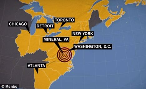
Virginia, US Shaken AGAIN: More Than 20 Aftershocks From 5.8 East Coast Earthquake Now Felt

Virginia Quake
© The Daily Mail, UKNew quake: The epicentre of this latest earthquake, measuring 3.4, was just four miles from Mineral, where last week's 5.8 quake started
Central Virginia has been shaken by another aftershock from last week's earthquake that rattled the East Coast.

The U.S. Geological Survey reported a 3.4 magnitude aftershock at 5.09am this morning.

The epicentre was four miles south-southeast of Mineral, the town that was the epicentre of last Tuesday's 5.8-magnitude earthquake.

More than 20 aftershocks ranging from 4.5 to 1.8 have followed the earthquake.

Bizarro Earth

Banda Sea - Earthquake Magnitude 6.8

Banda Quake_300811
© USGSEarthquake location.
Date-Time:
Tuesday, August 30, 2011 at 06:57:41 UTC

Tuesday, August 30, 2011 at 03:57:41 PM at epicenter

Time of Earthquake in other Time Zones

Location:
6.401°S, 126.774°E

Depth:
465 km (289.0 miles)

Region:
BANDA SEA

Distances:
272 km (169 miles) NNE of DILI, Timor-Leste

337 km (209 miles) SSW of Ambon, Moluccas, Indonesia

473 km (293 miles) ESE of Baubau, Sulawesi, Indonesia

806 km (500 miles) NW of DARWIN, Northern Territory, Australia

Bizarro Earth

US: Earthquake may have exceeded Virginia nuke plant's safeguards

The earthquake that prompted the shutdown of a Virginia nuclear power plant last week may have been more severe than the plant's reactors were designed to withstand, federal regulators said.

The revelation is likely to put increased pressure on the Nuclear Regulatory Commission (NRC) to quickly implement a series of safety recommendations intended in part to protect plants from major natural disasters like earthquakes.

Image
© Unknown
NRC said Monday that its preliminary analysis indicates that the ground motion caused by the magnitude-5.8 earthquake near the North Anna Power Station in Louisa County, Va., exceeded the maximum level the two reactors at the plant were built to handle.

But the commission noted in a statement Monday that "data is still being collected and analyzed to determine the precise level of shaking that was experienced at key locations within the North Anna facility."

Bizarro Earth

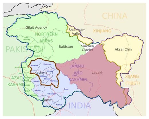
Sixth Tremor Hits Kashmir in 8 days

Kashmir Valley
© Opus88888 / WikipediaMarking the three regions of the Indian state of Jammu and Kashmir: Jammu, Kashmir valley and Ladakh.
Srinagar - A moderate intensity earthquake, sixth in eight days, was felt in the Kashmir valley midnight, officials said here Saturday. Coordinator Disaster Management Cell Kashmir, Aamir Ali said the tremor of magnitude 5.4 on Richter scale occurred at 2.02 am.

The jolt was epicentred in Feyzabad, Afghanistan at 36.44 degree north latitude and 70.69 degree east longitude, he said.

Earlier, from August 19 to 23, five moderate earthquakes measuring between 4.8 to 5.1 on Richter scale recorded in the Valley.

Amir Ali said that earthquakes are a natural phenomenon caused due to movement of techtonic plates.

"We cannot stop earthquakes but we can certainly take measures to prevent damages due to earthquakes."
Radar

10,000 Earth Tremors Recorded On German-Czech Border

czech map
© Google MapsEpicentre of a 3.6 magnitude earthquake which struck on Friday. (click to enlarge)
The Geophysical Institute, Academy of Sciences of the Czech Republic says it has recorded almost 10,000 earthquakes during the last three days in West Bohemia, a region located close to the Czech Republic's western border with Germany.

The earthquake swarm started late on Tuesday and continued through Friday. While many have gone unnoticed by the local population some of the larger tremors, including eight quakes exceeding 3 magnitude have been felt in the towns of Chemnitz, Karlovy Vary, Birch, and Luby.

The most recent earthquake measured 3.6 magnitude on the Richter Scale and hit at 0645hrs GMT on Friday at a shallow depth of three miles. The quake epicentre was located 81 miles (129 km) NE of Nürnberg 82 miles (131 km) SW of Dresden, 90 miles (144 km) W of Praha, 128 miles (204 km) NW of Budejovice, 131 miles (210 km) NNW of Schärding, and 227 miles (364 km) NW of Wien.

Bizarro Earth

Vanuatu - Earthquake Magnitude 6.2 - 24th August

Vanuatu Qukae_240811
© USGSEarthquake Location
Date-Time:
Wednesday, August 24, 2011 at 23:06:16 UTC

Thursday, August 25, 2011 at 10:06:16 AM at epicenter

Time of Earthquake in other Time Zones

Location:
18.180°S, 167.730°E

Depth:
10.1 km (6.3 miles)

Region:
VANUATU

Distances:
79 km (49 miles) SW of PORT-VILA, Efate, Vanuatu

221 km (137 miles) NW of Isangel, Tanna, Vanuatu

299 km (185 miles) SSE of Luganville, Espiritu Santo, Vanuatu

1827 km (1135 miles) ENE of BRISBANE, Queensland, Australia