Earth ChangesS


Bizarro Earth

Thunderstorms Kill 43 People in India

Fierce thunderstorms have uprooted trees and destroyed hundreds of homes, crushing dozens of people to death and injuring scores of others in northern India.

At least 43 people were killed and 70 hurt in the deluge and squalls.

The powerful storms slashed a wide swath across Uttar Pradesh and Bihar states, uprooting trees and power pylons and damaging homes and crops.

In eastern Uttar Pradesh, 21 people were killed and about 50 others injured when heavy rains lashed the region, police spokesman Surendra Srivastava said.

"A majority of the victims were crushed under uprooted trees or when houses collapsed due to the squall,'' he said.

Better Earth

Ireland Earthquake shakes up record books

Image
An earthquake has shaken the west of Ireland for the first time since records began.

Locals felt their houses shaking and heard loud bangs as the mini-quake, measuring 2.6 on the Richter scale, hit north Clare on Thursday night.

Liscannor resident Martin Doyle said: "I felt the whole roof shake. I thought the wall was collapsing. My neighbour called and he thought that the sound he heard was me falling down the stairs."

Rosemarie Buckley, who lives nearby, also said: "The house shook and we heard a loud bang."

Her husband Tom added: "We didn't know what it was. We thought it might have been a meteorite or something."

Bizarro Earth

Magnitude 6.1 - Sumbawa Region, Indonesia

Sumbawa Earthquake
© USGSEarthquake Location
Date-Time:
Saturday, May 08, 2010 at 03:22:11 UTC

Saturday, May 08, 2010 at 11:22:11 AM at epicenter

Location:
8.122°S, 118.238°E

Depth:
20.1 km (12.5 miles)

Distances:
65 km (40 miles) NW of Bima, Sumbawa, Indonesia

240 km (150 miles) ENE of Mataram, Lombok, Indonesia

280 km (175 miles) NW of Waingapu, Sumba, Indonesia

1275 km (790 miles) E of JAKARTA, Java, Indonesia

Life Preserver

Best of the Web: What took US media so long to report this? Nashville Tennessee Flood 2010


Cloud Lightning

Best of the Web: North Pole rainfall 'bizarre': climatologist

north pole
Spring showers are next to non-existent in the High Arctic, so Environment Canada's senior climatologist says he's baffled to hear that it rained near the North Pole this week.

A group of British scientists working off Ellef Ringnes Island, near the North Pole, reported being hit with a three-minute rain shower over the weekend. The group reported the rain on Tuesday.

Rain in the High Arctic in April is nothing short of bizarre, said David Phillips, senior climatologist with Environment Canada.

"My business is weird, wild and wacky weather, and this is up there among fish falling from the sky or Niagara Falls running dry," Phillips told CBC News in an interview that aired Thursday.

"I mean, it really is strange. You just don't expect it to rain in the High Arctic in April; maybe in July and August. And certainly for these scientists from Europe coming over, they must have been also mystified."

Phillips said 50 to 60 years of historical weather data show no signs of rainfall ever occurring in April in the High Arctic.

The earliest account of measurable rainfall at Canadian Forces Station Alert took place on May 21, 1988, he said.

Comment: There was another related report about freak snowing in Antarctica nearly two years ago:

Something Strange is Happening at the Coldest, Driest Place on Earth
"Everyone talks about the melting of the glaciers but having day after day of rain in Antarctica is a totally new phenomenon. As a result, penguins are literally freezing to death."
...

With all that ice, it might seem kind of backwards to call snow at the South Pole "freaky," but it is. The Antarctic is literally a desert of ice with an average of 1-inch of precipitation each year.
...

Within hours the crystals thickened and turned heavy - and soon visibility would be completely chocked off. By midnight a rare easterly rose, climaxing at to 40 knots. What began as a crystal dance now turned to a full-blown blizzard - the equivalent of torrential rain in the middle of the Sahara. What I was seeing was real, the world had indeed turned upside-down, and it would be more than a week before it could right itself.


Umbrella

At least 39 killed in storms in Chongqing, south China

Image
© China DailyA traffic policeman directs vehicles on a flooded downtown road in Xinhua county of Hunan province on Thursday. At least four people were killed there and many other roads flooded in the torrential rains.
Chongqing - Storms killed at least 39 people in the southwestern and central parts of the country from Wednesday night to Thursday, local government authorities said.

As of 4 pm on Thursday, 29 people had died in the Dianjiang and Liangping counties as well as Fuling district of Chongqing municipality, with one other person missing, local government sources said.

Similarly, torrential rain that started at 2 am on Thursday in Xinhua county of Hunan province also killed four people and left one other person missing, authorities said.

The rains also triggered massive landslides and mudslides.

The extreme weather that started on Wednesday night in Chongqing had left 190 people injured as of 3:45 pm on Thursday.

The storms hit seven counties in Chongqing, with Hanjia and Pengshui reporting rainfall of up to 157 mm in the 24 hours to noon on Thursday, while wind speeds of up to 112 km per hour lashed worst-hit Dianjiang and Liangping.

"The trees in front of my house were uprooted or broke into half. My house roof, which was made of steel boards, was also ripped apart," said Liangping resident Huang Hongzhi.

"I have never seen it this bad before," he told China Daily.

Cloud Lightning

Update: 65 killed in south China rainstorms

Image
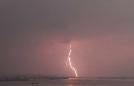
© CFPLightning illuminates the sky during a thunderstorm in Qingyuan, South China's Guangdong province, May 6, 2010.
Beijing - The death toll from fierce storms and torrential rains that ravaged southern China this week has risen to 65 with tens of thousands left homeless, authorities said Friday.

As of Friday, the storms had affected up to 2.55 million people and 100,000 hectares of arable land, leaving 65 people dead, 14 missing, 9,900 buildings damaged, said the Office of State Flood Control and Drought Relief Headquarters in a statement on its website.

Heavy rain has poured down in south China since Wednesday, including provinces of Guangdong, Sichuan and Guizhou, causing floods, mountain torrents and mud flows.

The office initiated a level-four emergency response on Friday to cope with the chaos caused by storms sweeping its southern provinces.

The office has ordered local authorities to closely monitor the development of the rainstorms, prevent weather-triggered disasters like floods and landslides and provide early warnings.

The office has also dispatched working teams to storm-hit regions to enhance storm-relief work, it said.

Gear

Welcome aboard Volcano air-lies: Volcanic ash air chaos to return within days because of wind direction changes

Image
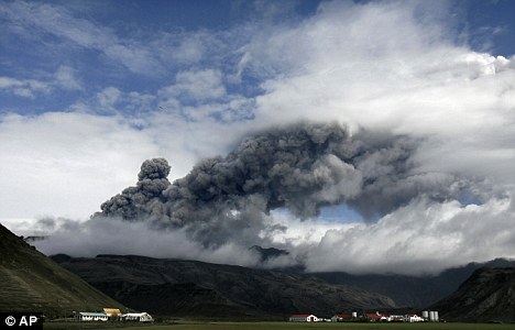
© APActivity from the Eyjafjallajökull volcano has increased, taking the ash plume to a height over 30,000ft
Air chaos from volcanic ash may return within days because of wind direction changes, weather forecasters and aviation chiefs warned last night.

The warning came just hours after all UK and Irish airspace re-opened yesterday following two days of disruption centred on Scotland, Ireland and the North of England.

It also came as the Icelandic volcano at the heart of the problem yesterday increased the amount of ash it is belching out.

Bizarro Earth

'Massive' ash cloud closing western Irish airports

Image
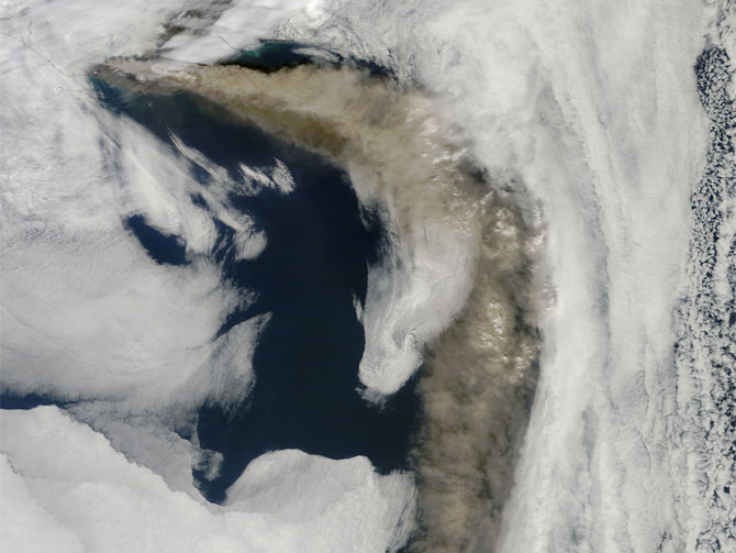
© NASA/Goddard/MODIS Rapid Response Team NASA's Terra satellite flew over the Eyjafjallajokull Volcano, Iceland, on May 6 at 11:55 UTC (7:55 a.m. EDT). The Moderate Resolution Imaging Spectroradiometer instrument known as MODIS that flies onboard Terra, captured a visible image of the ash plume. The plume was blowing east then southeast over the Northern Atlantic. The satellite image shows that the plume is at a lower level in the atmosphere than the clouds that lie to its east, as the brown plume appears to slide underneath the white clouds.
Dublin - Iceland's volcano has produced a 1,000-mile-wide (1,600 kilometer-wide) ash cloud off the west coast of Ireland that will force western Irish airports to shut down again Friday, the Irish Aviation Authority announced.

The authority said shifting winds, currently coming from the north, had bundled recent days' erupted ash into a massive cloud that is growing both in width and height by the hour.

Eurocontrol, which determines the air routes that airliners can use in and around Europe, says the ash accumulation is posing a new navigational obstacle - because the cloud is gradually climbing to 35,000 feet (10.5 kilometers) and into the typical cruising altitude of trans-Atlantic aircraft. Until recent days, the ash had remained below 20,000 feet (6 kilometers).

The Irish Aviation Authority said the engine-wrecking ash would skirt Ireland's western shores Friday, forcing a half-dozen airports to ground flights for much of the day. However, the airports in Dublin, Cork in the southwest and Waterford in the southeast will remain open.

"The restrictions are required as the increased level of recent volcanic activity has created a massive ash cloud stretching 1,000 miles long and 700 miles wide," the authority said in a statement.

Bizarro Earth

US: Several Tennessee rivers set records

Image
© UPI
Nashville - A U.S. Geological Survey study shows many rivers in middle Tennessee set high flow records due to heavy rainfall last weekend.

Preliminary estimates released Thursday show the highest stream flows were observed from Nashville west toward Jackson, extending about 40-miles north and south of Interstate 40 and affecting major tributaries of the Cumberland and Tennessee Rivers.

Flows on the Harpeth River exceeded 46,000 cubic feet per second May 3, while the Duck River near Hurricane Mills flowed at 138,000 cfs May 4, exceeding the previous high by 17,000 cfs, the USGS said.

Flood peaks on the Harpeth near Bellevue, Piney River at Vernon, and Duck River at Hurricane Mills appear to have exceeded levels expected with only a 0.2 percent probability (1 in 500 chance) in any given year.