Earth ChangesS


Bizarro Earth

Large amounts of nitrogen stored beneath selected agricultural areas

Large amounts of nitrogen are stored in the soils of agricultural areas in Nebraska and Maryland, according to a new study by the U.S. Geological Survey (USGS) and the U.S. Department of Agriculture (USDA). Once in the soil, nitrogen can be converted to nitrate, which can readily move to groundwater.

"We expected to find nitrogen stored in organic matter in these soils, but didn't realize how much," said Tom Nolan, USGS hydrologist, who led the study. "If mobilized, the large reservoirs of nitrogen could significantly impact water quality."

Nitrogen occurs in soil, plants, and groundwater, and it is difficult to account for all of the various forms it can take. For this study, scientists at the USGS National Water Quality Assessment Program and the USDA Agricultural Research Service used a new version of the Root Zone Water Quality Model to estimate unsaturated zone nitrogen mass balances at four agricultural fields. The study was reported in the May/June 2010 edition of the Journal of Environmental Quality, published by the American Society of Agronomy, the Crop Science Society of America, and the Soil Science Society of America.

The mass balances were expected to reveal the predominant forms of nitrogen in important agricultural settings. The four sites had variable climate, soils, and management practices, and included: an almond orchard in central California; a cornfield that is about 0.6 kilometers from the almond orchard; a corn-soybean crop rotation in eastern Nebraska; and a corn-soybean rotation in eastern Maryland.

Bizarro Earth

Expert Views on the Deepwater Horizon Incident and Aftermath

mexico oil well blowout
© Unknown
I had the pleasure of listening in to a phone conference on Friday organized by Morgan Stanley's oil field services' analyst, Ole Sorer. The topic was the Deepwater Horizon disaster, including what went wrong, who is liable, and what some of the longer-term impacts to the E&P industry might be. The discussion leaders included Mike Smith, a 15-year veteran of Transocean (since retired) and two attorneys who have dealt with oil spill litigation in the past. I learned a lot, and thought I'd share some of their perspectives with the readers of Seis Matters.

According to the Transocean veteran, BP had discovered significant quantities of oil and gas at Macondo, the name of the field that the Deepwater Horizon rig was drilling. BP had reached total depth and penetrated the reservoir horizon at 18,000 feet. Halliburton had cemented the last casing string in the well and inserted several cement plugs within it which BP intended to drill out at some future point when they returned to Macondo to begin full-field development.

With the cement plugs in place, Transocean had begun the process of removing the drill string in the well (used during the cementing operation) and had begun to replace the heavier mud in the wellbore with less dense sea water. This is apparently a common practice, as the plugs are designed to contain the reservoir fluids downhole. Effectively, the Deepwater Horizon was hours away from moving off the Macondo location.

Hourglass

Timeline: 20 Years Of Major Oil Spills

Oil Rig - Timor Sea
© UnknownIn August 2009, up to 30,000 tonnes of oil spilled into the Timor Sea after the West Atlas oil rig began leaking oil and gas
March 24, 1989 - The oil tanker Exxon Valdez hits Prince William Sound's Bligh Reef in Alaska, spilling 40.9 million litres of crude oil. It is thought to be one of the worst man made environmental disasters ever.

1991 - The Gulf War oil spill is estimated to be the largest oil spill in history. In order to ward of a potential landing by United States marines, the Iraqi military dumped up to 1.5 million tonnes of oil from several tankers into the Persian Gulf. The oil damaged the ecosystem in the Persian Gulf, around Kuwait and Iraq.

Bizarro Earth

Magnitude 6.1 - Izu Islands, Japan Region

IZu Island Earthquake
© USGSEarthquake Location
Date-Time:
Monday May 03, 2010 at 10:27:45 UTC

Monday, May 03, 2010 at 07:27:45 PM at epicenter

Location:
29.614°N, 141.064°E

Depth:
82.3 km (51.1 miles) set by location program

Distances:
300 km (190 miles) NNW of Chichi-shima, Bonin Islands, Japan

405 km (250 miles) SSE of Hachijo-jima, Izu Islands, Japan

535 km (335 miles) N of Iwo Jima, Volcano Islands, Japan

685 km (425 miles) S of TOKYO, Japan

Bizarro Earth

Magnitude 6.4 quake shakes Chile, no damages

Santiago - The U.S. Geological Survey says a magnitude-6.4 earthquake has struck off Chile's central coast. There were no immediate reports of damage or injuries.

The USGS says the quake's epicenter was 151 kilometers (94 miles) south-southwest of Concepcion, Chile, at a depth of 20 kilometers (12 miles).

Igloo

Back to Ice Age? Korea Shivering With Unusual Cold

Image
© Choi Heung-sooTwo people in coats walk down a street in central Seoul, Wednesday, as midday high temperatures stood at 7.8 degrees Celsius in Seoul, the lowest for late April since 1908.
Spring is overdue ― way long overdue. And for office worker Beh Hye-lim, a portable heater is still a must-have item in her office in southern Seoul.

Despite efforts to stay warm, the 27-year-old has been struggling with cold from chilly weather for days.

''Warm rays of sunshine were usual at this time in previous years. But it's literarily freezing,'' she said sneezing.

The entire Korean Peninsula is shivering with a record-low spring chill ― the midday high temperature for Seoul recorded 7.8 degrees Celsius and 6.7 degrees for Daejoen, 170 kilometers south from the Seoul, Wednesday, the lowest for late April since 1908, according to the Korea Meteorological Administration (KMA).

The mercury across the country is forecast to do down further Thursday, with some snow expected in mountainous areas in Gangwon Province.

"The unusual chill is likely to continue until mid May,'' the state weather agency said, adding, ''Rain and accompanying wind made people feel much colder.''

The lowest mid-day temperature for late April in Seoul was 10.1 degrees Celsius, set on April 27, 1962.

Cloud Lightning

Cumberland River Floods Nashville as record rainfall leaves 20 dead

Image
© Unknown
Storms Kill 6 In Nashville, Evacuate Thousands From Homes

Nashville, Tennessee - The Cumberland River was expected to crest sometime Monday evening but would not begin receding until Tuesday, according to the Nashville mayor's office.

The Cumberland flooded quickly after the weekend's storms dumped more than 13 inches of rain in Nashville over two days. That nearly doubled the previous record of 6.68 inches of rain that fell in the wake of Hurricane Fredrick in 1979.

The weekend thunderstorms killed at least 20 people in Tennessee, Mississippi and Kentucky. At least six people were killed in Nashville.

Floodwater continued to rise Monday midday in downtown Nashville, shutting down most of lower Broadway including First and Second avenues. The Schermerhorn Symphony Center and numerous buildings downtown near the Cumberland River had lower-level flooding.

Heartland Christian Towers residents are being moved to hotels or picked up by family members. The retirement home is on Fernbrook Lane off McGavock Pike in Nashville.

Air 4 flew over a flooded home along Pennington Bend that was engulfed in flames at 10:30 a.m. The NWS advised that major flooding is expected to continue along Cumberland River Monday followed by a gradual decrease in water levels, and that homes in the area should be evacuated.

Arrow Down

Nashville Flooding Devastates City as Interstate-24 Becomes River

Image
© UnknownThe worst rains in Tennessee's history turned highways into rivers overnight
The Nashville, Tennessee flooding has gotten totally out of control with an Interstate being turned into what looks just like a river. Many cars are flooded in the river of an interstate. It is all just crazy and horrible! This Nashville flooding has been the worst rain that they have ever seen in all of Nashville's entire history.

Below I have a CNN video which shows a lot cars that are submerged in the water as well as a school building that has lost its ability to stay on land and is literally floating down Interstate 24 (I-24). The Harpeth River was forced to rise by 26 feet by Saturday evening which has in turn caused major flooding of the metro area in Nashville.

Emergency personnel have been having to do emergency evacuations of people from their homes as well as endure over 50 rescues of people from the floodwaters. At this time, people are homeless and having to live in shelters. Right now the Red Cross and Lipscomb University has offered to shelter the homeless due to the flooding.

Attention

Spring storm dumps snow on northeastern US

Image
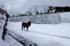
© Toby Talbot, APA horse is seen through a snow-covered fence in a pasture in Calais, Vt., Wednesday, April 28. A spring snowstorm dumped 12 to 18 inches of snow in some areas of Vermont, according to the National Weather Service.
Montpelier, Vermont - A late-season snowstorm dumped up to 2 feet of heavy, wet snow on northern New York, Vermont and New Hampshire by Wednesday morning, cutting off power to thousands, closing some schools and leaving roads slippery.

"It definitely caught people off guard, considering we had 80 degrees back in March. It's a problem because some people swapped their (snow) tires out already," said Vermont highway dispatcher Greg Fox.

About 30,000 customers were without power in Vermont, New Hampshire and northern New York at 8:30 a.m. Wednesday. Utility officials said it could be Thursday before power is fully restored.

"We've been hammered all night," said New York State Police Trooper Eric LaValley of the Ray Brook barracks, in the Adirondack Mountains.

Large storms so late in the season are rare. On April 23, 1993, 22 inches of snow was reported in Malone, N.Y., and on April 27, 1874, 24 inches of snow was reported in Bellows Falls, Vt., said Mark Breen, the senior meteorologist at the Fairbanks Museum and Planetarium in St. Johnsbury.

Attention

Hail, sleet and snow slams southern California

Image
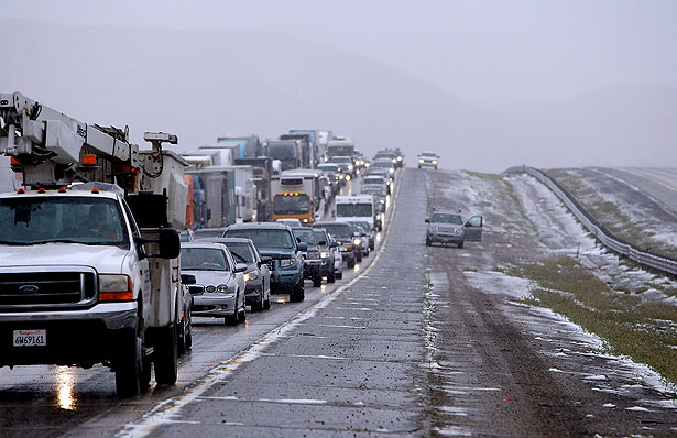
© Kirk McKoy / Los Angeles TimesNorthbound Interstate 5 is gridlocked as inclement weather conditions shut down parts of the freeway Thursday morning.
High winds, low temperatures and snow in some mountain areas forced closure of Interstate 5 over the Grapevine on Thursday morning as forecasters warned of gusts of up to 50 mph in parts of Southern California.

[Update at 10:45 a.m.: As of 9:30 a.m., lanes in both directions of Interstate 5 were reopened to traffic.]

Shortly after 7:30 a.m., the California Highway Patrol closed the southbound lanes of Interstate 5, and then about 8:15 a.m. shut down the northbound lanes at Vista del Lago.

"We've got icy roadway, hail, snow, black ice. You name it, it's up there," said CHP Officer Robert Rodriguez.

Officers were called out on about 20 crashes on the northern slope of the Grapevine early Thursday, including one in which a car ran into the back of a big rig, Rodriguez said. One motorist suffered moderate injuries.