Earth ChangesS


House

Canada: Lake Manitoba swallowed homes - residents

manitoba storm damage
© CBCMany homes and cottages along the south shore of Lake Manitoba have been severely damaged by Tuesday's violent storm
Residents along Twin Beach Road worked hard to protect their properties from flooding, but their efforts proved no match for a storm packing 90 km/h winds on rain-swollen Lake Manitoba.

The storm hit on Tuesday, damaging numerous properties in the Rural Municipality of St. Laurent - Twin Lakes Beach, Laurentian Beach, Delta Beach, and Sandpiper Beach.

David Sawicky said Wednesday he had to wade into rising floodwaters at his home to rescue his father and his dog.

Still, Sawicky said, he didn't expect the damage to his property to be that bad.

Bell

Rain, snowmelt combine to increase flood threat in the US

Torrential rainfall and record snowmelt are contributing to a slow-motion flood disaster along the Missouri River and its tributaries in the northern Rockies and northern Plains.


Newspaper

4,300 Guard members responding to U.S. floods

US guard
© US ArmyPfc. Brian Smith places sandbags on a levee at the Pierre, S.D., Water Reclamation Plant to protect the facility from flood waters
The number of National Guard members responding to severe spring flooding rose to about 4,300 over the weekend as parts of the Missouri River began to swell in states such as North Dakota, South Dakota and Nebraska.

Other states such as Tennessee, Vermont and Wyoming are also seeing flooding as flood operations in Kentucky come to a close.

As of 5 p.m., May 31, 2011, about 2,000 North Dakota Guard members were on state active duty in response to rising waters in Burleigh, Morton and Ward Counties as the U.S. Army Corps of Engineers opened dams up-river that are over-saturated with heavy rainwater and snowmelt.

Book

US: Flood of 2011 one for the history books

historic flooding photo
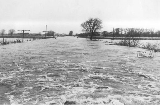
Historic flooding photo
Since the 1850s, the Mighty Missouri's flow proved instrumental to the development of Sioux City.

Riverboats plied its waters from St. Louis to Sioux City providing the goods, products and people to turn a frontier town into a thriving city on the plains. Through the years, the Missouri bit back - flooding the tri-state area numerous times and causing millions of dollars worth of damage.

By Journal accounts, the flood of 1952 surpassed all previous records, including the historic flood of 1881.

The river reached its crest of 24.3 feet on the morning of Monday, April 14, 1952, according to Journal stories. The swollen river easily overtook its banks, inundating North Sioux City, Sioux City, South Sioux City and points south.

By comparison, due to a series of upriver dams and channelization, the Missouri's depth in Sioux City is 28.05 as of 4 p.m. Wednesday. Flood level is 30 feet.


Umbrella

India: Heavy rains lash Punjab, Haryana

Punjab, Haryana and Chandigarh were lashed by heavy rains and high velocity winds last night, disrupting power supply at many places.

After receiving showers yesterday morning, rains and thunder squall with a wind speed of over 45 kmph hit Chandigarh last night.

Power supply was disrupted at many places in the city and it took a few hours before it could be restored. Many low-lying areas were water-logged and trees could be seen uprooted this morning.

Some residents here also complained that their electrical appliances were damaged due to excess voltage from trees falling on power lines.

Cloud Lightning

US Drought Monitor: Heavy rainfall hits the Midwest, temperatures warming up

US drought monitor

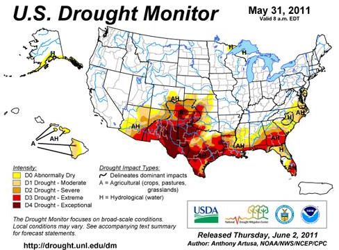
Weekly Weather Summary: The period began with a widespread area of severe weather (mainly strong winds and large hail) across the East Coast states, though with minimal tornadic activity, especially when compared to the previous week. Several other severe weather events followed in the days ahead, first over the middle Mississippi Valley and southern Great Lakes region, and then over the northern and central Great Plains. A widespread area of heavy precipitation (2 inches or greater) was observed from Kansas and Nebraska eastward across the middle Mississippi Valley and southern Great Lakes region. Unfortunately, this broad area doesn't need the rain, whereas the drought areas to the south (southern Plains, Gulf Coast, and South Atlantic states) received little in the way of beneficial rain. Temperatures averaged anywhere from 4 to 10 degrees (F) above average across most of the East, Ohio and Tennessee Valleys, Gulf Coast states, lower half of the Mississippi Valley, the southern Plains, and the interior Southwest. Elsewhere, which includes much of the northern and western CONUS, temperatures generally ranged from 4 to 10 degrees (F) below average.

Bizarro Earth

US: North and South Dakota prepare flood evacuations

Salmon, Idaho - Authorities pressed a mandatory evacuation on Wednesday in flood-hit parts of Minot, North Dakota, and South Dakota's governor urged residents to evacuate parts of the capital ahead of rising flows from the swollen Missouri River.

Police and National Guard soldiers went door-to-door in Minot urging up to 12,000 residents to evacuate as officials cut natural gas service to neighborhoods affected by rising waters along the Souris River, a Red River tributary.

Flooding on the Souris has eclipsed records set in damaging floods in 1976 and 1969 and forced Amtrak to suspend service on its Empire Builder line west of St. Paul due to track closings and damage to its Minot station.

Volunteers, contractors and National Guard soldiers and airmen were racing on Wednesday to extend and raise levees in North and South Dakota cities including both state capitals to hold back the rising Missouri River.

Bacon

US: Officials Plan to Exterminate San Diego County's Wild Pigs

Image
A study found that the rooting behavior of feral pigs in California reduces the number and size of oak tree seedlings.
When it comes to controlling the spread of feral pigs in San Diego County, the public hunting effort isn't doing the job.

That has led federal agencies to launch an ambitious program that will use cage traps, corral traps, federal hunters with guns and dogs and even shooting from helicopters to exterminate the area's population of wild swine. Officials see the pigs as a threat to fragile ecosystems and public health and safety. Environmentalists worry about the damage wild pigs will do to the county's sensitive habitat, much of it rebounding from Southern California's catastrophic wildfires of the last decade.

The U.S. Forest Service estimates there are 200 to 300 feral pigs in San Diego County. There's also a small sounder of pigs near the Riverside County border that likely was there prior to the release of pigs in late 2006 on the Capitan Grande Indian Reservation behind El Capitan Reservoir in the San Diego River bed. Hunters who spend a lot of time in the backcountry say the population is three to four times that now and it will be useless to try and eradicate them.

Still, the Forest Service and the Bureau of Land Management are developing a plan to eliminate as many feral pigs as possible, as soon as possible.

Cloud Lightning

Heavy Rains, High Winds in Manitoba Damage Homes, Force Residents to Flee

Image
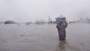
© (CBC)A resident in Twin Lakes Beach, in the RM of St. Laurent, wades through high waters to save belongings during Tuesday's flood and storm.
Heavy rain and extreme wind have caused extensive flooding and wind damage around Lake Manitoba and in southwestern parts of the province.

The Manitoba government says 16 people had to be rescued Tuesday, including one person who had to be lifted out by helicopter in the Rural Municipality of St. Laurent.

So far, 238 people who evacuated from the area have registered with the Red Cross.

Several roads have been washed out or overtopped with water and the government says they will have to be inspected before evacuees can return.

More than 700 seasonal and permanent properties have been on mandatory evacuation notices around Lake Manitoba due to flooding.

Cloud Lightning

US Kansas: Quick Flooding Prompts Evacuations in Manhattan

Image
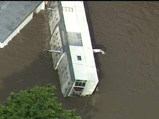
© NBC Action News.comJUNE 2, 2011: Skytracker flies over Manhattan, Kansas, where flooding of the Wildcat Creek prompted the evacuation of hundreds of residents
Heavy rain that quickly pushed creeks out of their banks in north-central Kansas chased hundreds of people from their homes for several hours Thursday, turning parts of the region into a maze of closed roads.

In Riley County, police ordered about 200 people to evacuate houses and apartment complexes before dawn Thursday in a low-lying area along Wildcat Creek in Manhattan. Several inches of rain that began falling Wednesday night swelled the creek and raised the Kansas River.

Flooding along Wildcat Creek isn't unusual, but police Capt. Kurt Moldrup said Thursday's episode was "the worst flooding that we've seen in this area." The creek began receding by midday and most roads reopened, allowing residents to go home to their houses, apartments and vehicles, many of them damaged by water.

The American Red Cross opened a shelter at St. Thomas More Church, but it appeared unlikely that many people would need to stay there Thursday night.