Earth ChangesS


Arrow Up

Earthquake Swarm attacks New Brunswick Town - 35 Tremors in 5 Weeks

McAdam
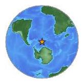
© Kuzwa/Wikipedia CommonsMcAdam, New Brunswick, has been struck by over 35 minor tremours — called an “earthquake swarm” — in the past five weeks.
Springtime in McAdam, a tiny village in southwestern New Brunswick not far from the Maine border, is like springtime in most other parts of Canada. Locals chatter about the NHL playoffs, the garden they are planting, the grass that needs to be cut, the fish they can't wait to catch and the cottage they can't wait to get to, once the warm weather really settles in.

Lately, however, an interloper has elbowed its way into the community's daily dialogue. Pushing aside the playoffs. Pushing its way to the very top of the talking points.

"Everybody is talking about the earthquakes," says David Blair, a retired science teacher and lifetime McAdam resident from his home on Old Harvey Road, just east of downtown.

Bizarro Earth

Gulf Seafood Deformities Alarm Scientists

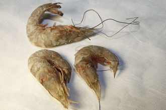
Eyeless shrimp, from a catch of 400 pounds
© Erika Blumenfeld/Al JazeeraEyeless shrimp, from a catch of 400 pounds of eyeless shrimp, said to be caught September 22, 2011, in Barataria Bay, Louisiana.
Eyeless shrimp and fish with lesions are becoming common, with BP oil pollution believed to be the likely cause.

"The fishermen have never seen anything like this," Dr Jim Cowan told Al Jazeera. "And in my 20 years working on red snapper, looking at somewhere between 20 and 30,000 fish, I've never seen anything like this either."

Dr Cowan, with Louisiana State University's Department of Oceanography and Coastal Sciences started hearing about fish with sores and lesions from fishermen in November 2010.

Cowan's findings replicate those of others living along vast areas of the Gulf Coast that have been impacted by BP's oil and dispersants.

Gulf of Mexico fishermen, scientists and seafood processors have told Al Jazeera they are finding disturbing numbers of mutated shrimp, crab and fish that they believe are deformed by chemicals released during BP's 2010 oil disaster.

Along with collapsing fisheries, signs of malignant impact on the regional ecosystem are ominous: horribly mutated shrimp, fish with oozing sores, underdeveloped blue crabs lacking claws, eyeless crabs and shrimp - and interviewees' fingers point towards BP's oil pollution disaster as being the cause.

Bizarro Earth

Monsanto Blamed for Bee Collapse, Buys Leading Bee Research Firm

Honey Bee
© Alex Wild / alexanderwild.comA honeybee forager visits fall asters in Urbana, Illinois.
Monsanto, the massive biotechnology company being blamed for contributing to the dwindling bee population, has bought up one of the leading bee collapse research organizations. Recently banned from Poland with one of the primary reasons being that the company's genetically modified corn may be devastating the dying bee population, it is evident that Monsanto is under serious fire for their role in the downfall of the vital insects. It is therefore quite apparent why Monsanto bought one of the largest bee research firms on the planet.

It can be found in public company reports hosted on mainstream media that Monsanto scooped up the Beeologics firm back in September 2011. During this time the correlation between Monsanto's GM crops and the bee decline was not explored in the mainstream, and in fact it was hardly touched upon until Polish officials addressed the serious concern amid the monumental ban. Owning a major organization that focuses heavily on the bee collapse and is recognized by the USDA for their mission statement of "restoring bee health and protecting the future of insect pollination" could be very advantageous for Monsanto.

Igloo

Ice Age Cometh? Forecasters predict the "Coldest May in 100 years"

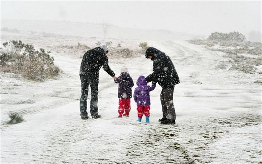
Britain could be facing the coldest May for 100 years, with snow, bit
snow
© Tim Ireland/PAA family walk in the snow in the Brecon Beacons, south Wales
ter winds and freezing temperatures putting summer on hold.


The winter weather follows a wet start to April, with the threat of floods and storms to come over the next few days.

The Met Office has issued weather warnings for the South West, London, South East, Wales and the West of England due to flooding on roads and 60mph winds.

Hail storms are expected across the country and it is feared windows could be broken by giant hail, up to 1cm thick. In the north and Scotland temperatures could fall to -2C.

Despite the ongoing drought, heavy downpours could cause localised flooding, even in areas where there is hosepipe ban in place.

Independent forecaster WeatherAction has also predicted the next month will be the "coldest or near coldest for 100 years" in the East of England, with cold northwesterly winds.

Cloud Lightning

Three Gorges Dam danger may force out 100,000 people

Image
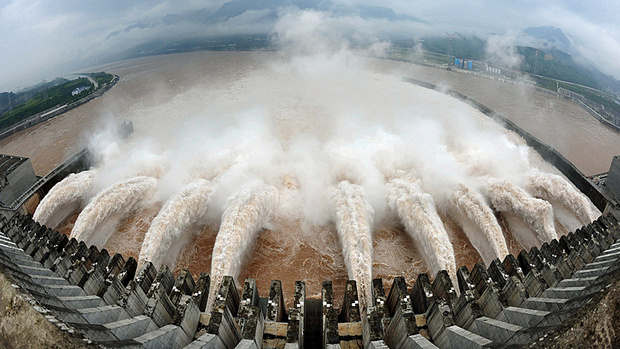
© Xinhua, Cheng Min/Associated Press)Flood water is released from the Three Gorges Dam's floodgates in Yichang, in central China's Hubei province, in this July 20, 2010 photo by China's Xinhua news agency.
Landslides and other disasters up 70% since the water level hit maximum level in 2010

Another 100,000 people may have to move away from China's Three Gorges Dam due to the risk of disastrous landslides and bank collapses around the reservoir of the world's biggest hydroelectric facility, state media said Wednesday.

The Ministry of Land Resources says the number of landslides and other disasters has increased 70 per cent since the water level in the $23 billion showcase project rose to its maximum level in 2010.

Some 1.4 million people already have been resettled due to the huge project on the Yangtze River. Authorities may move another 100,000 people in the next three to five years to minimize the risk of casualties from such threats, Liu Yuan, a ministry official, told China National Radio in a report posted on a government website and carried by the Shanghai Daily newspaper.

Fish

Eyeless Shrimp? Report Raises Concerns in Gulf

Mutant creatures showing up after BP spill, says Al Jazeera English

Shrimp missing their eyeballs (and even eye sockets), fish covered in lesions, deformed crabs, and other mutated sea creatures are showing up in unsettling numbers in the Gulf of Mexico two years after the giant BP oil spill, according to an investigation by Al Jazeera English. "The fishermen have never seen anything like this," says one scientist at Louisiana State University. "And in my 20 years working on red snapper, looking at somewhere between 20 and 30,000 fish, I've never seen anything like this, either."

The sentiment is echoed by several others interviewed in the article, both fishermen and scientists. The BP disaster released 4.9 million barrels of oil into the water, and the company then poured in 1.9 million gallons of chemical dispersants to sink the oil. Biologists are pointing to the toxins in the dispersants as the catalysts behind the abnormalities. Despite the signs, both the state and BP says the local seafood is rigorously tested and safe to eat.

Bizarro Earth

Mexico's Erupting Popocatépetl Volcano Spied from Above

Popocatépetl Volcano
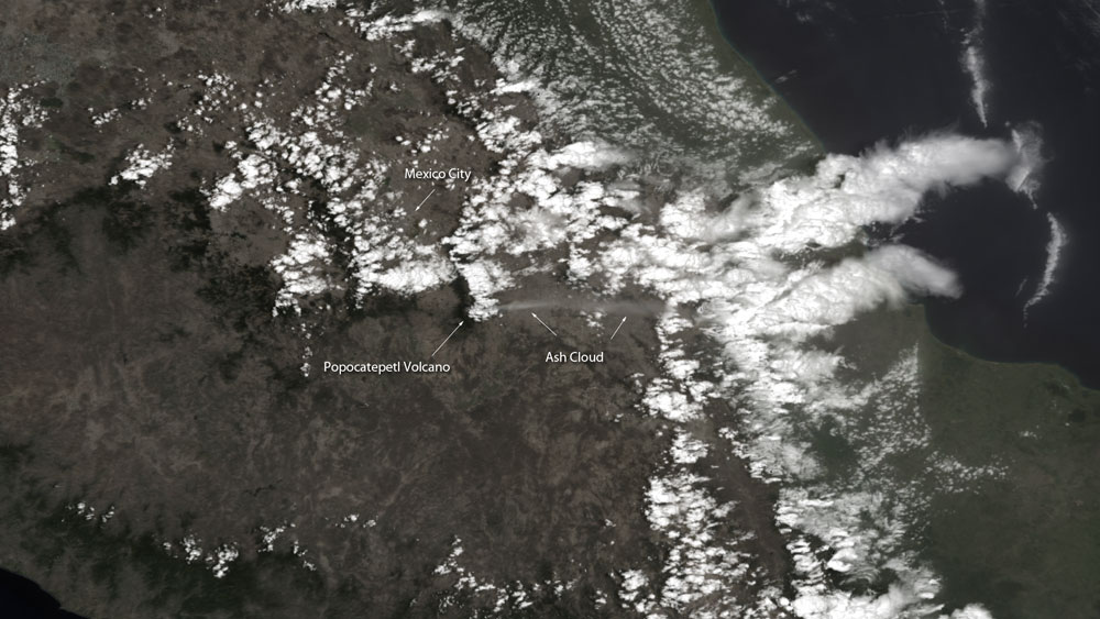
© NOAAThe Suomi NPP satellite snapped this image of Mexico's Popocatépetl volcano on April 16, 2012 after a new eruption that sent an ash plume high into the sky.
Mexico's Popocatépetl volcano, which lies only about 40 miles away from Mexico City, dusted nearby areas with ash this week in one of its largest explosions in recent years. The eruption, combined with a billowing plume of steam and ash and increased seismic activity, has prompted authorities to raise the volcano's alert status and advise people to stay at least seven miles away from the summit.

The eruption covered about 30 communities with ash, ranging from a light dusting to up to 7 centimeters (2.8 inches), according to Wired's Eruptions Blog.

There are signs that new magma inside the volcano is near the surface, says Eruptions Blog author Erik Klemetti, a professor of geosciences at Denison University in Ohio.

Popocatépetl, whose name means "smoking mountain" in Aztec, is the second highest volcano in North America, at 17,802 feet (5,426 meters). Only Mexico's Pico de Orizaba is taller.

The volcano's alert status has been raised to Yellow Stage 3, the third highest stage, by Mexico's National Center for Prevention of Disasters. There are seven total alert stages.

Bizarro Earth

BP's Corexit Oil Tar Sponged Up by Human Skin

Corexit® dispersed oil residue
© James H “Rip” Kirby III, Surfrider FoundationCorexit® dispersed oil residue accelerates the absorption of toxins into the skin. The results aren't visible under normal light (top), but the contamination into the skin appear as fluorescent spots under UV light (bottom).
The Surfrider Foundation has released its preliminary "State of the Beach" study for the Gulf of Mexico from BP's ongoing Deepwater Horizon disaster.

Sadly, things aren't getting cleaner faster, according to their results. The Corexit that BP used to "disperse" the oil now appears to be making it tougher for microbes to digest the oil. I wrote about this problem in depth in "The BP Cover-Up."

The persistence of Corexit mixed with crude oil has now weathered to tar, yet is traceable to BP's Deepwater Horizon brew through its chemical fingerprint. The mix creates a fluorescent signature visible under UV light. From the report:
The program uses newly developed UV light equipment to detect tar product and reveal where it is buried in many beach areas and also where it still remains on the surface in the shoreline plunge step area. The tar product samples are then analyzed...to determine which toxins may be present and at what concentrations. By returning to locations several times over the past year and analyzing samples, we've been able to determine that PAH concentrations in most locations are not degrading as hoped for and expected.
Worse, the toxins in this unholy mix of Corexit and crude actually penetrate wet skin faster than dry skin (photos above) - the author describes it as the equivalent of a built-in accelerant - though you'd never know it unless you happened to look under fluorescent light in the 370nm spectrum. The stuff can't be wiped off. It's absorbed into the skin.

Arrow Up

Rare River Porpoises Showing up Dead

Dead Porpoise
© Xu Dianbo/China DailyVolunteers from Yueyang, Hunan province, carry the corpse of a finless porpoise from Dongting Lake on Saturday.
Within the last month and a half, the corpses of 12 endangered finless porpoises, including a pregnant one, have been found around Dongting Lake, Hunan province.

It has triggered worries from experts about the rare species possibly becoming extinct.

Scientists said finless porpoises, which have lived in the Yangtze River and adjacent lakes for more than 20 million years, will become extinct within 15 years. The porpoises are also called "river pigs".

"Apparently the prolonged drought and low water level due to climate change and increasing offshore human activities are reducing the living space for finless porpoises, accelerating its extinction," Wang Kexiong, an expert of the Institute of Hydrobiology under the Chinese Academy of Sciences, told China Daily.

It is the first time he has heard of so many dead porpoises found within such a short period.

Xu Yaping, a journalist from Hunan's Yueyang city who is campaigning to ensure the survival of the species, said when most of the corpses were dissected no food was found in their digestion systems.

Xie Yongjun, an associate professor of animal husbandry at Yueyang Vocational and Technical College, told China Daily the porpoises may have died due to starvation, poisoning or infectious disease.

There were no obvious injuries in the three corpses he dissected, Xie added.
Bizarro Earth

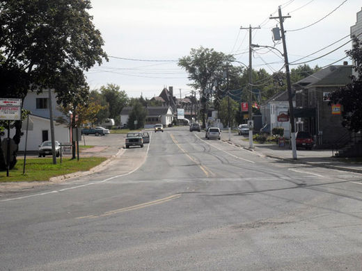
USGS: Earthquake Magnitude 6.2 - East of The South Sandwich Islands

Sandwich Islds Quake_170412
© USGSEarthquake Location
Date-Time:

Tuesday, April 17, 2012 at 19:03:55 UTC

Tuesday, April 17, 2012 at 06:03:55 PM at epicenterTime of Earthquake in other Time Zones

Location:

59.099°S, 16.693°W

Depth:
1 km (~0.6 mile) (poorly constrained)

Region:
EAST OF THE SOUTH SANDWICH ISLANDS

Distances:

563 km (349 miles) E of Bristol Island, South Sandwich Islands

677 km (420 miles) ESE of Visokoi Island, South Sandwich Islands

2685 km (1668 miles) SE of STANLEY, Falkland Islands

4091 km (2542 miles) SE of BUENOS AIRES, D.F., Argentina