Earth ChangesS


Cloud Lightning

Bizarre hailstorm dumps four feet of hail in Texas Panhandle

Image
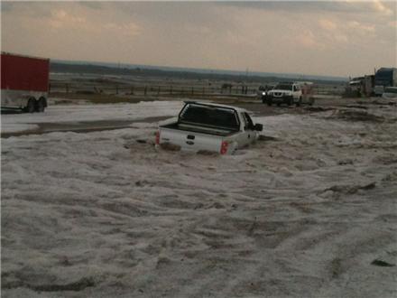
© Doug Black/KVIIAn unusual spring storm in the Texas Panhandle Wednesday afternoon dumped two to four feet of hail near Dumas.
Video | News | Weather | Sports

Thu Apr 12 06:10:35 PDT 2012

Photos: Spring hailstorm pelts Texas Panhandle

An unusual spring storm in the Texas Panhandle Wednesday afternoon dumped two to four feet of hail near Dumas. view full article


An unusual spring storm in the Texas Panhandle Wednesday afternoon dumped two to four feet of hail near Dumas.

Trucks were reported sliding off the road on Highway 287 as a result of the unexpected weather phenomenon. Snow plows were being used to clear the roads.

Some vehicles were trapped in the drifts of hailstones.

Chief Meteorologist Pete Delkus said a tornado watch was in effect for the Panhandle region through 10 p.m. Wednesday, and the storms were moving very slowly between Pampa and Dumas north of Amarillo and to the east of Dalhart.

Melting hail and heavy rain triggered flash flooding in the Panhandle.

Bizarro Earth

USGS: Earthquake Magnitude 5.5 - Southern Greece

Image
© USGS
Date-Time:
Monday, April 16, 2012 at 11:23:44 UTC
Monday, April 16, 2012 at 02:23:44 PM at epicenter

Time of Earthquake in other Time Zones

Location:
36.771°N, 21.692°E

Depth:
36 km (22.4 miles)

Region:
SOUTHERN GREECE

Distances:
55 km (34 miles) SW of Kalamata, Greece

135 km (83 miles) SSE of Zakynthos, Greece

169 km (105 miles) S of Patrai, Greece

232 km (144 miles) SW of ATHENS, Greece

Blackbox

Underground water in eastern Shasta County California mysteriously disappears

Image
© Andreas FuhrmannStephen Wolf of Cassel is a former United States Geological Survey worker who has a theory about why wells are running dry in eastern Shasta County.
Stephen Wolf thinks something strange is happening underground in eastern Shasta County and it is draining water wells and maybe even causing sinkholes and subsiding pavement.

A retired marine geologist with the U.S. Geological Survey, Wolf said he has seen what is happening in eastern Shasta County before. After the 1989 Loma Prieta earthquake, water well levels in the area of the quake fell significantly, he said.

Following the 6.9 magnitude quake in the Santa Cruz Mountains, Wolf wrote a paper for the USGS about the effects the quake had on surface and groundwater.

"The correlation is there. The behavior is identical," said Wolf, who has lived in the tiny eastern Shasta County community of Cassel since 2001.

Back in October, 131 earthquakes hit the Lassen Peak area. Most were less than 2.0 in magnitude. But since then the water table has fallen significantly, Wolf said.

Snowflake

Top Scientists, Government Agencies and Publications Have - For Over 100 Years - Been Terrified of a New Ice Age

ice age London
© Twentieth Century Fox
Fear of the Big Freeze

There has been an intense debate among leading scientists, government agencies and publications over whether the bigger threat is global warming or a new ice age. As we've previously noted, top researchers have feared an ice age - off and on - for more than 100 years. (This post does not weigh in one way or the other. It merely presents a historical record.)

On February 24, 1895, the New York Times published an article entitled "PROSPECTS OF ANOTHER GLACIAL PERIOD; Geologists Think the World May Be Frozen Up Again", which starts with the following paragraph:
The question is again being discussed whether recent and long-continued observations do not point to the advent of a second glacial period, when the countries now basking in the fostering warmth of a tropical sun will ultimately give way to the perennial frost and snow of the polar regions.
In September 1958, Harper's wrote an article called "The Coming Ice Age".

On January 11, 1970, the Washington Post wrote an article entitled "Colder Winters Held Dawn of New Ice Age - Scientists See Ice Age In the Future" which stated:
Get a good grip on your long johns, cold weather haters - the worst may be yet to come. That's the long-long-range weather forecast being given out by "climatologists." the people who study very long-term world weather trends.

Dominoes

Planet Earth Is Cracking Up

Image
© unk
A leading earthquake scientist has warned that the planet could be cracking up after a series of massive quakes in just 48 hours.

Expert Gheorghe Marmureanu - from Romania's National Institute of Earth Physics - says 39 quakes had hit the globe within two days.

The series started with two massive quakes in Indonesia measuring 8.6 and 8.2 on the Richter scale rapidly followed by three more only slightly smaller in Mexico within hours.

"There is no doubt that something is seriously wrong. There have been too many strong earthquakes," said Marmureanu.

Comment: Perhaps this article can lend some insight as to the possible reasons why Earth is Cracking up:
Planet-X, Comets and Earth Changes by J.M. McCanney


Stop

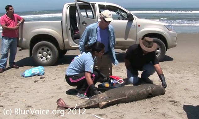
Mass Dolphin Deaths in Peru Blamed on Oil Seeking Sonar Blast

The deaths of thousands of dolphins washed up on beaches in Peru may have been caused by acoustic testing offshore by oil companies, conservationists have warned.

Nearly 3,000 of the mammals are thought to have died this year so far, with 615 counted by conservationists along a 90-mile stretch of beaches near the city of Lambayeque on Wednesday.

Scientists in Peru are exploring the possibility the deaths were caused by sonar blasts used by firms to find oil under the sea. The method can damage dolphins' ears and cause disorientation and internal bleeding, experts warn.

Dead Dolphin
© BlueVoice.orgConcerned: Conservationists in Peru counted 615 dead dolphins along a 90-mile stretch of beaches on Wednesday.

Orca Peru expert, veterinarian Carlos Yaipen Llanos said that while 'we have no definitive evidence', he suspects the cause of death is a 'marine bubble', which occurs during mining exploration.

The bubbles are not visible to the naked eye but they can have an effect on dolphins, sea lions, and whales.

Cloud Lightning

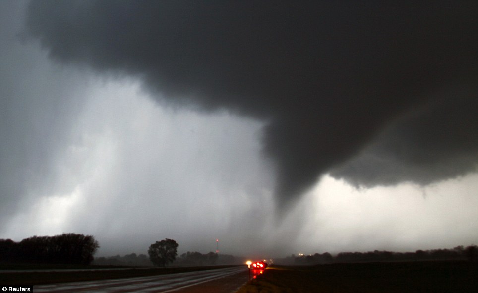
Tornadoes batter Midwest US: Five dead and at least 37 injured in Oklahoma as twisters rip through hospitals, homes and tear apart entire towns

  • Twister hits northwest town of Woodward, Roscoe Hill, where sirens were 'not working'
  • Two children are among the dead amid fears that death toll could rise
  • More than 120 tornadoes reported
  • Storm Prediction Center calls outbreak a potentially 'high-end, life-threatening event'
  • Heavy winds have already destroyed 75 per cent of Thurman, Iowa
  • Tornado ripped through hospital in Creston, Iowa
  • Large hail damaged homes and vehicles in and around Petersburg, Nebraska
  • Other tornados touched down in southwest Kansas, Oklahoma
  • Tornadoes predicted to get worse as authorities issue 24-hour high-risk warning for the second time in history
Twister
© ReutersTwister: Hundreds of tornadoes tore through the midwest including this one making its way over the 135 freeway near Moundridge, Kansas

Bizarro Earth

Incredible Images Show Giant Sinkhole In Sweden Keeps Expanding!

It looks like something taken straight from a horror movie. An enormous hole leading to hell, some would say. But this is not a movie.

This is a real and dangerous phenomenon. New shocking images clearly show the enormous pit in Sweden is expanding.

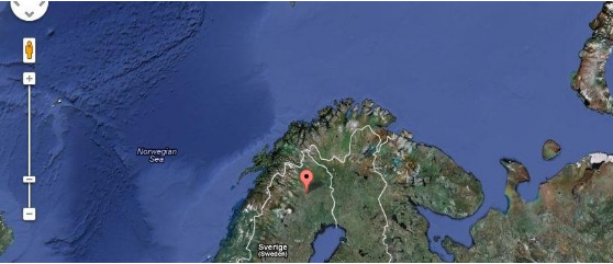
The 200 foot wide open pit is called the "Fabiangropen" (Fabian pit) and is in the Malmberget area is located at Gällivare, 75km from Kiruna, Sweden.

As you can see on the map, it is in the northern regions of Sweden.

Map hole Sweden

Comment: Sinkholes - A Sign of the Times?


Bizarro Earth

USGS: Earthquake Magnitude 6.2 - Off The Western Coast of Northern Sumatra

Sumatra Quake_150412
© USGSEarthquake Location
Date-Time
Sunday, April 15, 2012 at 05:57:38 UTC

Sunday, April 15, 2012 at 11:57:38 AM at epicenterTime of Earthquake in other Time Zones

Location
2.549°N, 90.277°E

Depth
15.2 km (9.4 miles)

Region
OFF THE WEST COAST OF NORTHERN SUMATRA

Distances
651 km (404 miles) WSW of Banda Aceh, Sumatra, Indonesia

687 km (426 miles) SSW of Mohean, Nicobar Islands, India

1254 km (779 miles) ESE of COLOMBO, Sri Lanka

2077 km (1290 miles) WNW of JAKARTA, Java, Indonesia

Bizarro Earth

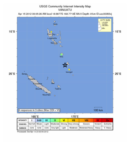
USGS: Earthquake Magnitude 6.5 - Vanuatu

Vanuatu Quake_150412
© USGSEarthquake Location
Date-Time
Saturday, April 14, 2012 at 22:05:26 UTC

Sunday, April 15, 2012 at 09:05:26 AM at epicenterTime of Earthquake in other Time Zones

Location
18.998°S, 168.771°E

Depth
8.7 km (5.4 miles)

Region
VANUATU

Distances
80 km (49 miles) NW of Isangel, Tanna, Vanuatu

148 km (91 miles) SSE of PORT-VILA, Efate, Vanuatu

297 km (184 miles) NNE of Tadine, Loyalty Islands, New Caledonia

1864 km (1158 miles) ENE of BRISBANE, Queensland, Australia