Earth ChangesS


Cloud Lightning

'Himalayan tsunami' toll rising

Indian officials estimate deaths at around 1000 as they try to reach thousands of pilgrims still stranded.

Image
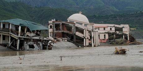
© APA damaged government guest house falls into the flooded water of the River Ganges in Shrinagar district, in the northern Indian state of Uttarakhand, India.
Soldiers in the north of India were battling against time to reach thousands of stranded pilgrims and tourists before the onset of further rains and landslides.

As officials said the death toll from the "Himalayan tsunami" could be as high as 1000, troops and emergency workers were still trying to reach 50,000 people who remain stranded in the state of Uttarakhand.

It emerged that soldiers had spotted around 1000 pilgrims close to the famous Kedarnath shrine; they have been taking shelter in ravines since the monsoon rains last week. India's home minister Sushilkumar Shinde visited Uttarakhand yesterday.

With warnings from meteorologists that more rains were on their way, he set a three-day deadline to complete the rescue efforts. The authorities appear to be struggling to deliver hard data: reports say that the 10,000 soldiers have so far rescued anywhere between 35,000 and 70,000 people. But there have been reports in the Indian media that thousands of people remain unaccounted for.

Officials said the death toll had reached at least 600 as Uttarakhand's Chief Minister, Vijay Bahuguna, said 560 bodies were buried deep in mud caused by the landslides. At the same time, it was reported that another 40 corpses were found floating in the Ganges, close to the holy town of Haridwar.

But officials fear the final death toll could leap as rescuers reach more and more pilgrim sites that have been inaccessible for a week. "The death toll could be more than 750 - maybe around 1000," Bahuguna said.
Snow Globe

Mount Hutt ski area in New Zealand closed due to too much snow

"Looks like manmade global warming is terrifying in New Zealand," says reader Joshua Cooley.
small payday loans

"Wasn't it supposed to be, later winters, earlier springs, less snow, no snow, higher snow levels, kids won't know snow, etc., etc.?"

Image
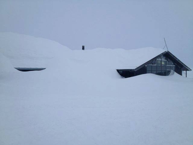
Mt Hutt, New Zealand -21Jun13
New Zealand just got hammered with snow (See It's Dumping Down Under!)

At Mt Hutt the storm dropped 40 inches of snow in 20 hours! This led to 15 foot snow drifts and extremely high avalanche danger.

And the snow keeps falling! Another 40 cm is forecast over the next 24 hours.

According to the Mt Hutt website, the ski area "is closed again today as further heavy snow falls and low visibility have hampered the progress of snow clearing on the access road. We estimate at least 1.6m of snow has fallen since the storm began and drifts exceeding 3m deep are commonplace in many areas.... All lifts are currently heavily caked in ice."

http://unofficialnetworks.com/avalanche-slams-mt-hutts-snowmaking-building-40-snow-20-hours-123369/

Thanks to Joshua Cooley for this link

Snow Globe

Thaw causing historic flooding on both sides of Pyrenees

What melting snow can do.

Remember our article First time ever skiing in the Pyrenees in June - 'It's just like the middle of January'?

Here's what happens when snow starts melting:

Thaw causing historic flooding in Lleida - Spain


Igloo

Heavy snowfall in northern Kyrgyzstan in summer!

Snow in Summer
© Kabar
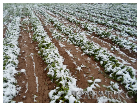
Bishkek - The snowfall in Naryn oblast on Monday reached in some places 40-50 centimeters. In some areas 3,5 and 15-50 centimeters. The press service of the authorized representative of the Government of the Kyrgyz Republic in Naryn oblast reports.

According to preliminary information, because of the snow 438 sheep and one mare with foal perished.

Besides, water level of rivers and canals rose because of snow.

Update - As a result of heavy snowfall on June 17-18 in northern Kyrgyzstan 1 thousand 866 sheep, 55 cows and 31 horses died in Naryn and Issyk-Kul oblasts. The press service of the Ministry of Emergency Situations of Kyrgyzstan reports.

The snowfall in Naryn oblast on Monday reached in some places 40-50 centimeters. In some areas 3,5 and 15-50 centimeters.

The commission of Civil Protection of regions continues to ascertain the damage of livestock farming and farmland.

Ice Cube

SOTT Focus: Behind the Headlines: Ice Age Cometh? Extreme Weather Events and 'Climate Change'

ice age
It's midsummer in the northern hemisphere, where record rainfall and the coldest spring in living memory have European meteorologists forecasting 'a year without summer' for most of Western Europe. While climatologists got their long-term forecasts for global warming all wrong, do these environmental extremes nevertheless signal 'climate change', just not in the way the authorities have portrayed it?

Extreme weather events are happening globally. One direct result of this is widespread crop failure. This leads to food shortages, followed by increased inflation as billions of people find themselves priced out of being able to eat. Riots and revolution are never far behind. In fact, complex systems theorists calculate that we're less than one year away from a fireball of global unrest. And that's not all...

The geological record shows that the default climate for this planet is a very cold one. Ice Ages last up to 100,000 years and are separated by 'inter-glacials', narrow windows of relative warmth that last, on average, 11,500 years. Our civilization is currently situated on the tail-end of the Holocene inter-glacial, meaning that it's just a matter of time before the next Ice Age.

How much time? Nobody knows. But in this week's show we're also going to examine the evidence for a synchronistic relationship between climate stress and the rise and fall of human civilizations within a more recent historical timeframe. Is it possible that humanity does play a role in modulating 'climate change', but perhaps not in the way environmentalists are suggesting?

Running Time: 02:19:00

Download: MP3


Evil Rays

Researchers dig into findings of unexplained sounds heard around the world

Across the country, entire communities have been reporting that strange, unidentifiable sounds have been heard in and around their areas.

These various sounds appear to fall into two categories: living and non-living. Though the two categories of sounds appear to be unrelated, the reports keep rolling in.

The living sounds appear to be originating from the ground-level and are often blamed creatures not yet known to science; such as Sasquatch, alien beings, or something else.

The non-living sounds appear to come from the sky and are contributed to UFOs, solar flares, and even the mysterious skyquakes. Below is a list of the most recent reports of mysterious sounds that fall into each category.

Incidents Around the World

Umatilla Reservation

Recently, TSW reported on the bone chilling screams heard in and around the Umatilla Reservation during the night. Locals and experts are at odds as to the sound's origin, but can agree that it seems to be biologic.

Cloud Precipitation

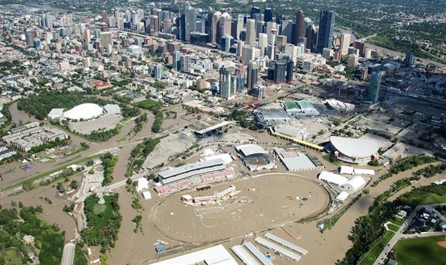
Calgary flood: Half a year's rainfall in one day - at least 75,000 people evacuated - highways and whole neighbourhoods washed away


The speed and extent of the flooding in southern Alberta has taken people in the province by surprise.

"Yesterday, I was kind of being a little flip about it. I could see what was going on in the mountains and that didn't surprise me," says Arlene Dickenson, one of the judges on the CBC TV show Dragon's Den, who has been watching the scene unfold from her condo in downtown Calgary.

"I woke up [this morning] and I went, 'Oh my god.' Shocked. I'm shocked."
Image
Calgary is completely flooded

Cloud Precipitation

Calgary, Alberta devastated in deluge of biblical proportions

Record rainfall, saturated ground and unforgiving landscape lead to devastation


Southern Alberta is no stranger to flooding, but this week's devastation from Canmore to Calgary and beyond was the result of a unique confluence of unexpected weather and a still partially frozen landscape unable to soak up the unprecedented deluge.

Hydrologists who watch the waterways like the Bow and Elbow rivers say several factors were at play since the rain started to fall about four days ago.

"To have these very large flood events ... the stars have to line up," says Uldis Silins, a hydrologist at the University of Alberta in Edmonton.

Image
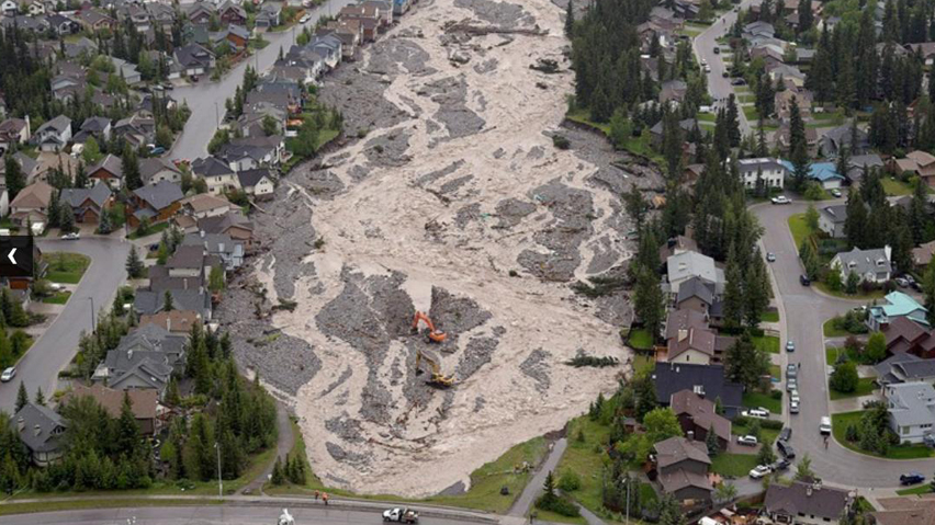
© Jonathan Hayward/Canadian Press Canmore's Cougar Creek is awash in mud and debris, following the heavy rains.

Ice Cream Bar

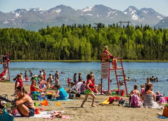
Extreme weather weirdness! Record-breaking heatwave scorches Alaska

In Alaska, old records are being crushed as a heatwave has carried temperatures into the 80s and 90s. In one part of Alaska, an unofficial 98°F!

Earlier this week (June 17-21, 2013), parts of Alaska began experiencing temperatures warmer than the daily averages for Hawaii or Florida at this time of the year: Alaska temps soared into the 80s and 90s. A large ridge of high pressure has provided sinking air and plenty of sunshine to help break many record-high temperatures across the state. This heatwave has been ongoing for the past several days. It has brought windy, dry, and warm conditions responsible for wildfires burning now in parts of Alaska, mainly in locations to the east of Fairbanks. This heatwave developed after Alaska experienced below-average temperatures throughout this past spring.
Image
© Alaska DispatchThe record-breaking heat in Alaska began last week and continued through this week.

Comment: Meanwhile, in Southern France...

Floods close Lourdes pilgrimage site in Pyrenees

French meteorologists: Summer 2013 could be Europe's coldest since 1816

Tune in to SOTT Talk Radio tomorrow when we'll be talking weather weirdness!


Cloud Precipitation

Thunderstorms knock out power to thousands in upper Midwest, U.S.

Severe storms producing wind gusts up to 85 mph, heavy rain and lightning strikes in Minnesota and Wisconsin early on Friday, knocked down trees and power lines and at one point left more than 176,000 customers without power.

An area stretching from the Dakotas through Wisconsin was bracing for more storms, some severe, later on Friday and possible flooding after reports of three to four inches of rain fell in some communities already, the National Weather Service said.

"The weather pattern is pretty much going to be stationary tonight and through the weekend so we are concerned about the severe weather and also the potential for flooding," said Jacob Beitlich, a weather service meteorologist in the Twin Cities.

The storms developed in the Dakotas and powered southeast through Minnesota into Wisconsin, bringing heavy straight-line wind damage with a gust of 85 mph at the heart of it northwest of the Twin Cities, he said.

The weather service also has issued a severe thunderstorm watch for parts of eastern Iowa stretching across northwest Illinois to just west of Chicago.