Earth ChangesS

Snow Globe

Warbler 'fallout' on Park Point, Dulth amazes birders

Starting last weekend and into the past week, birders in Duluth witnessed one of the most dramatic bird "fallout" events in many years

Image
© Mike HendricksonA mourning warbler seen at Park Point during a recent โ€œfalloutโ€ caused by bad weather
Starting last weekend and into the past week, birders in Duluth witnessed one of the most dramatic bird "fallout" events in many years.

Wind, rain and fog coming off Lake Superior forced migrating warblers and other species to take refuge on Park Point, where they flocked in trees and on the ground, resting and searching for food.

"It was fantastic," said Duluth birder Mike Hendrickson. "It was one of the best fallouts of migrants in my life, and I've been birding Duluth for 31 years."

It was good for birders, but tough on the birds, Hendrickson noted. He saw one dead warbler, but no other dead birds were reported.

In a message sent on the Minnesota Ornithological Union listserv, Duluth's Peder Svingen wrote that last Sunday, May 19, he and other birders identified 24 warbler species on Park Point. Only two of the 26 warbler species that can be observed in Duluth were missing, and they were later seen by others.

Cloud Precipitation

Heavy rain and flooding swamp city of San Antonio, TX - one dead, scores rescued - over 12 inches of rain in 24 hours


The wet weather plaguing many parts of the U.S. this holiday weekend has turned fatal in sodden San Antonio. One person is dead, another is missing and nearly a hundred more have been rescued as heavy rain has pummeled the Texas city, causing flash flooding. The majority of rescues were people trapped in their vehicles in low-lying areas of the city, San Antonio Fire Department spokesman Christian Bove told NBC News. Bove confirmed one fatality thus far, a 29-year-old woman who was trapped in her vehicle and tried to escape the rising water by climbing onto the car's roof. She was washed away, and her body was found down the road against a fence. A man who had been trapped in his vehicle is unaccounted for. Weather Channel Meteorologist Nick Wiltgen said San Antonio received 12.16 inches of rain in the 24 hours ending at 11 a.m. Central Time on Saturday. That is just shy of the 24-hour record for the city of 13.35 inches in October 1998. - NBC News

Bizarro Earth

Scientists mystified why Northern California earthquake was felt across such a large area

Image
A magnitude 5.7 temblor Thursday night was the largest earthquake to shake California since 2008 and has generated curiosity from seismologists. The temblor occurred in a rugged section of Northern California that has not been studied as thoroughly as Southern California and the Bay Area and has less monitoring equipment. Experts said they were surprised the quake was felt over such a large area, and they plan to go to the region to investigate. The magnitude 5.7 quake struck around 8:47 p.m., about 150 miles northeast of Sacramento; its epicenter was about 27 miles southwest of the town of Susanville. The last quake of similar magnitude, recorded at 5.5, struck Chino Hills in San Bernardino County in July 2008, said David Schwartz, an earthquake geologist for the Northern California USGS division in Menlo Park.

It caused little damage, but it was the most sizable quake to hit a metropolitan part of California since the much larger and destructive 1994 Northridge quake. Thursday's quake did occur in a zone with known active faults, said David Schwartz, an earthquake geologist for the Northern California USGS division, including a series of faults that extend through the northern end of Lake Tahoe all the way to Oregon. But 5.7 is the strongest magnitude recorded in the area. This mountainous eastern Sierra Nevada region, known for its lakes, rivers and national forests, has had about seven magnitude 4 earthquakes since the 1930s, Schwartz said. Scientists are still studying the intensity of Thursday's shaking and have moved seismographs there from more populated areas to monitor aftershocks.

Within minutes of the first quake, more than 7,000 people reported feeling it, from across state borders into Oregon and Nevada and as far south as the San Francisco area, according to the U.S. Geological Survey website. Officials in Susanville and Sacramento said the quake set off a number of home and car alarms and rattled windows. A Chico resident told The Times he felt a slow roll that lasted about 30 seconds.The quake itself was not a huge surprise for Schwartz's USGS division, but "what was interesting was it was felt along an unusual distance," he said. "Earthquakes in different parts of the state are felt over different distances. We just haven't had that many examples of earthquakes in this part of the state, really, for comparison. There are more interesting questions now than we have answers for, at present," he said. - LA Times

Arrow Up

Greater flamingos return to Gabon for the first time in decades

Gabon flamingos

Image
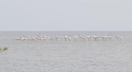
Greater flamingos have returned to Gabon
The Greater flamingo, Phoenicopterus roseus, a migratory species that had not been reported in Gabon for many decades, has been observed in Gabon's Akanda National Park.

The flamingos were spotted on the Gabonese coast during the tour organized as part of the commemoration of the World Migratory Bird Day.

The birds were seen on the mudflats of Moka Island; A total of 77 individuals, adults and immature birds, were observed. Apart from the flamingos, dozens of other species were spotted, including pelicans, black skimmers, Curlew sandpiper, yellow-billed stork, herons, storks, various terns, and more.

Unlike lesser flamingo, which is occasionally observed in Gabon, the Greater flamingo had completely disappeared from Gabon. Their return to the mudflats of Moka, in March 2013, is a testament to the remarkable richness of the environment, as well as the tranquillity found in the park, now that the Nigerian fishermen who had taken up residence have departed.

Bizarro Earth

Russian earthquake could be deepest ever

Sea of Okhotsk Quake
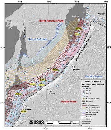
© USGSRecent earthquakes near the Sea of Okhotsk in Russia, including one of the deepest ever recorded.
The massive, magnitude-8.3 temblor that struck today (May 24) near Russia's Kamchatka Peninsula could turn out be the deepest earthquake ever recorded.

At 378 miles (609 kilometers) below the seafloor, the quake could best the previous record set in Bolivia, in 1994. The initial depth may be revised as scientists collect more data. The Bolivian quake was a magnitude-8.2, and 392 miles deep (631 km), Nature News reported.

Why so deep? The Sea of Okhotsk sits above a subduction zone, where the Pacific Plate dives beneath the North America Plate. (Though some scientists think there is also a microplate, a small tectonic plate, beneath the sea.) The northwest Pacific crust is some of oldest, coldest oceanic crust subducting on Earth. It's also quickly rolling into the subduction zone, like a speedy conveyor belt, so the cold crust reaches deep into Earth's mantle before warming up.

Bizarro Earth

USGS: Earthquake Magnitude 6.8 - Sea of Okhotsk (Aftershock)

Oshotsk quake_240513
© USGS
Event Time
2013-05-24 14:56:31 UTC
2013-05-25 00:56:31 UTC+10:00 at epicenter

Location
52.222ยฐN 151.515ยฐE depth=623.0km (387.1mi)

Nearby Cities
353km (219mi) WNW of Ozernovskiy, Russia
473km (294mi) W of Vilyuchinsk, Russia
476km (296mi) W of Yelizovo, Russia
491km (305mi) W of Petropavlovsk-Kamchatskiy, Russia
2061km (1281mi) NNE of Tokyo, Japan
Technical Details

Bizarro Earth

22 Aftershocks shake up northern California

At least 22 aftershocks have struck following an earthquake in far northeastern California that was felt as far away as San Francisco and in two other states.

There have been no reports of injury or serious damage.

Officials said the magnitude-5.7 quake broke dishes and shook mirrors when it hit at 8:47 p.m. Thursday.

The U.S. Geological Survey's National Earthquake Center said it was centered near Greenville, about 25 miles southwest of Susanville. It was followed by multiple aftershocks, including a magnitude 4.9 temblor that struck early Friday morning.

Pacific Gas & Electric said about 660 customers lost power on the southwestern edge of Lake Almanor at about 9:39 p.m. Thursday. The company did not immediately clarify whether the outage was due to the quake.

Bizarro Earth

Chirinkotan Volcano erupts in Kuril Islands of Far East Russia as Mexico's Popocatepetl volcano unleashes another wave

The remote volcano in the northern Kuriles is probably in eruption, the latest SVERT report and satellite images suggest. A plume of gas and steam, and possibly some minor amounts ash was seen with the MODIS sensor onboard the NASA Terra satellite this morning. Satellite data also indicate that activity had likely already started in early May, because a small thermal anomaly can be traced back on archive pictures to 7 May. One should take into account that frequent dense cloud cover often prevents such observations, so activity could have started earlier than that. It is not known what kind of activity is occurring at the volcano. Possibilities include some minor explosive (strombolian ?) activity at the summit, or lava flows that might be reaching the sea and produce the steam plume observed. The last eruption of the volcano was (probably) in 2004. - Volcano Discovery

Bizarro Earth

Alert level raised on Chile's Copahue volcano to orange after ash emissions

Image
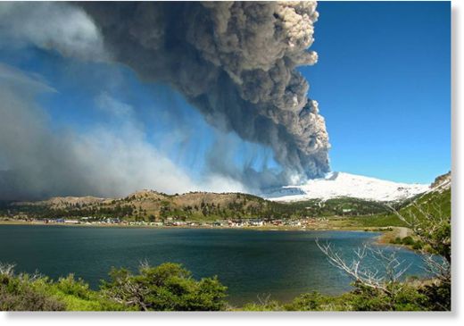
SERNAGEOMIN has raised the alert level to orange. Since May 15, a progressive increase in seismic activity as well emissions of gas and now some ash have been observed. Both earthquakes related to rock fracturing and fluid movements have picked up in numbers and possibly indicate a new magmatic intrusion on its way. This scenario is confirmed by the start of small ash emissions and glow at the crater which is visible at night. The plume of gas and ash could be seen from space by the MODIS sensor, stretching about 100 km to the southeast. Copahue volcano had already experienced a first increase of activity in December, and a second one in January. No eruption followed and alert was lowered to green in April before returning to yellow again soon after. - Volcano Discovery

Cloud Lightning

Wild hurricane season predicted - Three to six 'major' storms could emerge this year

Image
© Alan Diaz/AP/FileJames Franklin, Branch Chief of Hurricane Forecast Operations, points to a weather satellite map as he talks to a reporter at the National Hurricane Center in Miami, April 4.
The 2013 Atlantic hurricane season, which begins June 1, is shaping up to deliver above-normal activity again this year, according to several seasonal forecasts. Indeed, the season could be extremely active, according to Kathryn Sullivan, acting administrator of the National Oceanic and Atmospheric Administration (NOAA).

Forecasters at the agency's Climate Prediction Center anticipate from 13 to 20 tropical storms over the six-month season. Of those, between seven and 11 are expected to become hurricanes, with three to six of the hurricanes expected to reach "major" status, meaning they host maximum sustained winds topping 111 miles an hour.

The federal forecast, released Thursday afternoon, brackets other seasonal outlooks that also point to a busy season.

In April, for instance, researchers at Colorado State University in Fort Collins released their initial forecast for 2013, which included 18 tropical storms, of which nine are expected to become hurricanes. Four could become major hurricanes.