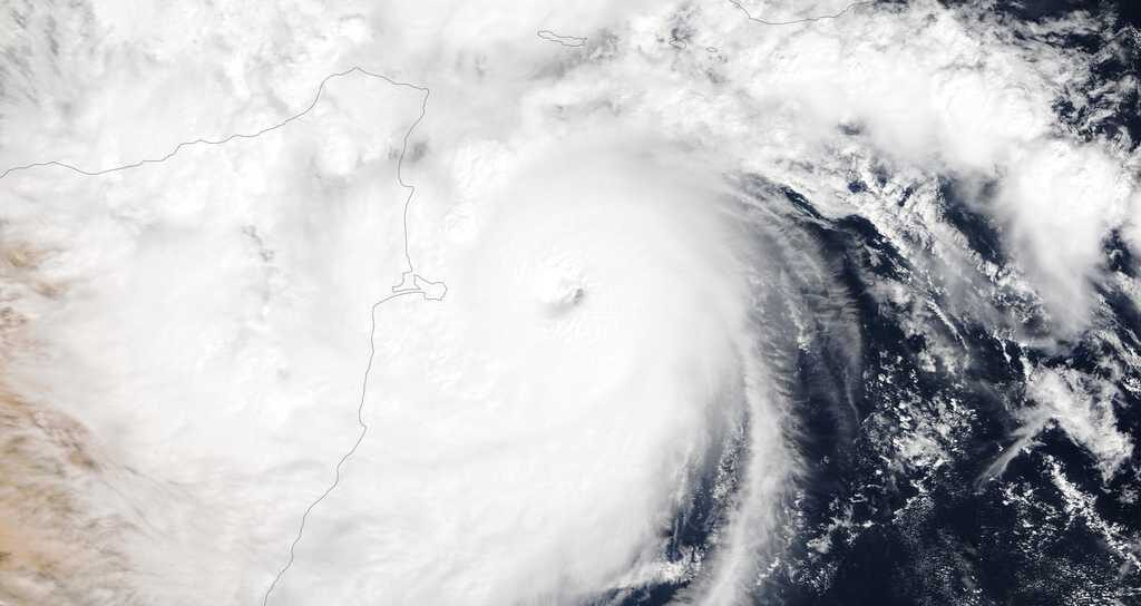
Tropical Cyclone Gati struck the arid nation of Somalia on Sunday as the equivalent of a Category 2 hurricane with 105 mph winds, making it the strongest storm on record to hit the country. The cyclone made landfall after undergoing an extraordinary period of rapid intensification, at one point attaining the strength equivalent to a Category 3 storm, with 115 mph maximum sustained winds.
Its landfall was farther south than any major hurricane-equivalent cyclone on record in that part of the world as well.
At least four people were reported dead from Gati, according to the Puntland Mirror. Landfall occurred near Xaafuun, a small community about 900 miles northeast of Mogadishu, where the land juts east near the northern tip of the country. Hordio and Ashira, both desert communities, were also directly affected by the core of the storm.
A broad four to eight inches of rainfall accompanied the system through northern Somalia, the driest part of the country, drenching desert regions with a year or two's worth of rainfall in just a matter of hours to a couple of days. Rains also swept through the Gulf of Aden and brushed up against Yemen.
Tropical Cyclone Gati has rapidly intensified from a 40kt tropical storm to 100kt category 3-equivalent cyclone in 6 hours, and currently making landfall in northeast Somalia.
— Sam Lillo (@splillo) November 22, 2020
So this stuff is not only happening in the Atlantic. pic.twitter.com/KxYTBvs5Fg
On Saturday evening, Gati had just surpassed the 39 mph threshold of tropical storm status, churning west toward Somalia. Overnight, though, its winds increased to 45 mph, and a bout of extremely rapid intensification quickly ensued. As the sun rose Sunday, winds were at 115 mph. Data shows the storm's winds increased by 70 mph in just 12 hours, a highly unusual occurrence particularly for this location.
A contributor to Gati's rapid intensification was its small size, which allowed the storm to respond quickly to changes in the surrounding environment and hastily gain strength.
Two other Indian Ocean Basin cyclones had jumped by 65 mph in 12 hours. Both of those storms did so in the Bay of Bengal, where the ocean basin's strongest storms are typically located.
Even more impressive is that Gati reached its maximum intensity at 10.3 degrees north, farther south than any other Indian Ocean cyclone on record.
Residents in coastal Somalia may have been caught off guard by the ferocity of the storm, unmatched by any other system in Somali history. Winds of 62 to 69 mph were predicted in a joint forecast issued by the Somalia Water and Land Information Management and the United Nations.
"Destruction of property and infrastructure including roads, buildings and boats due to the strong winds" was also anticipated. The bulletin urged fishermen and mariners, industries that make up the majority of Somalia's coastal economy, to evacuate the water and move inland.
The incredible and rare Fujiwara effect on full display in the Arabian Sea with two tropical cyclones orbiting around each other. pic.twitter.com/yQ3bED3Fto
— US StormWatch (@GreatWinter2017) November 21, 2020
In a display of elegance and discomfiting natural power, Gati was one of two tropical systems pinwheeling through the western Indian Ocean simultaneously. A second well-formed whirl, probably a tropical depression, orbited Gati to the east. The interaction between the two tempests played a role in helping steer Gati farther to the south, driving it directly into northern Somalia on an atypical route.
Rapid intensification becoming more frequent
Gati is the latest storm globally to rapidly intensify, a term reserved for tropical cyclones that spike in strength by 35 mph or more in 24 hours. Gati did so at double the rate needed to qualify for rapid intensification.
Ten storms rapidly intensified during the Atlantic's record 2020 hurricane season, complicating forecast efforts since a number of them continued strengthening through landfall, resulting in them hitting a peak intensity.
One storm in the Atlantic rivaled Cyclone Gati, as Hurricane Iota intensified at the astonishing rate of 80 mph in 24 hours before slamming into the coast of northeastern Nicaragua late Monday night.


Comment: Somalia's strongest tropical cyclone ever recorded could drop 2 years' rain in 2 days