So prepare to bundle up this winter.
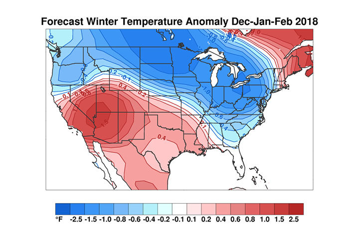
Expect a frigid winter with at least one visit from a lobe of the polar vortex, according to climate researchers funded by the National Science Foundation.
"I think the combination of La Niña and an anticipated disruption of the polar vortex could focus the worst of this winter's weather around the Great Lakes," said Judah Cohen, a meteorologist at Atmospheric and Environmental Research, a firm specializing in environmental research.
Although there's no immediate signs of weakening in the polar vortex, that could happen by January, Cohen said.
"All indicators favor a cold winter in the eastern U.S.," according to the report. "The combination of cold and wet could result in an above normal snow season for parts of the northern U.S., including the large population centers of the northeastern U.S."
Comment: Also See:
- Record-breaking cold temperatures for Boston, Massachusetts
- Return of the Polar Vortex? Arctic Cold Setting Dozens of Daily Records in the Northeast and Midwest
- Winter is here: Early snowfall hits western U.S (PHOTOS)
- Thanksgiving outlook: Brutal cold and snow will blast the Midwest; storm may brew in the East
The report, released Thursday, identifies areas around Lake Erie and in the northern Plains states to be the coldest from normal.
Temperatures averaging nearly 2 degrees below normal are expected in those areas for December, January and February, according to the report.
Researchers relied on various predictors when making the seasonal forecast, including the El Niño/Southern Oscillation, Eurasian snow cover extent during October, Arctic sea ice and another index measuring atmospheric patterns in the high latitude areas of the globe.
UPDATE: The Polar Vortex Returns: Massive cold wave headed for Eastern half of US, Florida
We've been watching this for a few days, and the forecast seems to be solidifying. Dr. Ryan Maue has some of the latest projections for snow and cold in the eastern USA. He notes:Over next 6-days, pattern locks in ... Pacific ridge vs. Eastern US trough. Watching the main event #PolarVortex over Hudson Bay next week.Cold will reach into south Texas and also Florida, while the Great Lakes and Northeast will shiver in the teens.
The cold and snow will be far-reaching:
The Met Office agrees:
Comment: The polar vortex was barely talked about a few years ago, now we hear about it every winter and how it'll be responsible for the unusually cold weather. Considering the shifts being witnessed on other planets, we can assume that there are great changes occurring in our solar system, and judging by the cyclical nature and history of our planets climate, it looks this 'inter-glacial' period may be coming to a close and that we're entering another ice age.
- Fire and Ice: The Day After Tomorrow
- Brace yourself, the polar vortex is shifting
- The state of ice and snow in Northern Hemisphere 2017
- Polar vortex or impending ice age?
- Polar vortex brings rare nacreous clouds to Britain
For more information on the big shifts happening, check out: Review: "Earth Changes and the Human-Cosmic Connection" Available here.


[Link]