Storms
S


Cloud Precipitation

Typhoon Phanfone will likely become 'super typhoon' heading to Japan

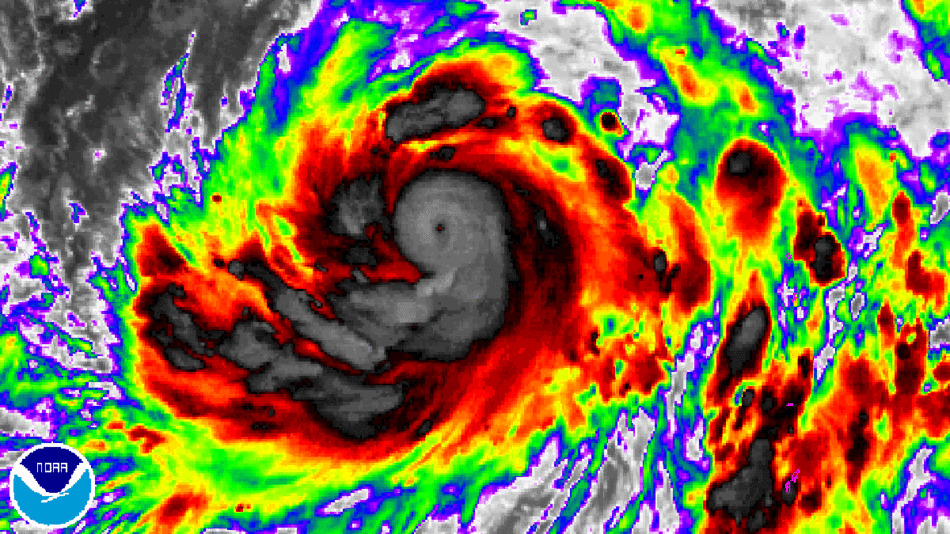
Typhoon Phanfone is gathering strength in the western Pacific Ocean, with projections showing that it may intensify significantly - likely to super typhoon status - before veering toward mainland Japan by Oct. 5.
Image
© NOAATyphoon Phanfone, currently over open waters of the West Pacific, may make landfall in Japan in a few days.
Computer-model simulations on Wednesday show that the storm will likely intensify over the next few days, while moving northwest, toward extreme southwest Japan or the open East China Sea. However, winds in the upper atmosphere should turn the storm north and then northeast, potentially making a direct hit on several Japanese islands, and scoring a direct hit on Tokyo as a Category One storm.

Japan has already been affected by three tropical cyclones this season, including Typhoon Halong, Tropical Storm Nakri and Typhoon Neguri. Southwest Japan has experienced widespread flooding from the combination of these storms and other weather systems.

Cloud Lightning

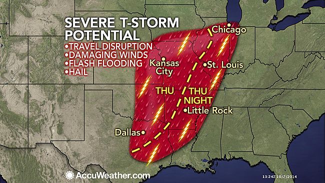
Powerful cold front to target 40 million from Illinois to Texas - 'wind, hail and torrential downpours'

Image
A powerful cold front will send severe thunderstorms towering in the air on Thursday putting many people in harm's way.

A zone from northern Illinois to northeastern Texas will be at the greatest risk for gusty winds, hail and torrential downpours through Thursday night.

"An active cold front sweeping across the center of the country on Thursday combined with a push of Gulf moisture into the Plains will set the stage for severe storms," said AccuWeather.com Meteorologist Evan Duffey.

These storms will threaten more than 40 million people as they target several major cities including Chicago; St. Louis; Springfield and Kansas City, Missouri; Little Rock, Arkansas; Memphis, Tennessee; Shreveport, Louisiana; and Dallas.

People in the path of the storms should expect travel disruptions from poor visibility and excess water on the roadways. Delays are be possible at major airports, including O'Hare and Dallas-Fort Worth.

According to AccuWeather.com Meteorologist Ed Vallee, Chicago will be at risk for storms beginning late in the day.

"Thunderstorms will develop ahead of the front Thursday afternoon and move into the Chicago area Thursday evening," said Vallee. "These storms could bring gusty winds, heavy rain and maybe even some small hail."
Cloud Lightning

Tropical Storm Rachel is dwarfed by developing system 90E

Image
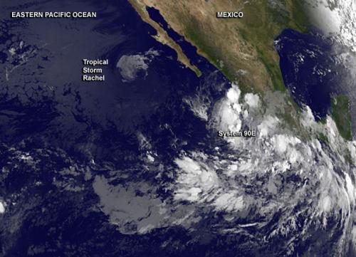
© NASA/NOAA GOES ProjectNOAA's GOES-West satellite captured an image of the smaller, fading Tropical Storm Rachel and the large developing System 90E in the Eastern Pacific on Sept. 30 at 8 a.m. EDT.
Tropical Storm Rachel is spinning down west of Mexico's Baja California, and another tropical low pressure area developing off the coast of southwestern Mexico dwarfs the tropical storm. NOAA's GOES-West satellite showed the size difference between the two tropical low pressure areas.

NOAA's GOES-West satellite captured an image of the Eastern Pacific Ocean on Sept. 30 at 1200 UTC (8 a.m. EDT). In the infrared image, Tropical Storm Rachel appeared small in comparison to the low pressure area called System 90E, coming together hundreds of miles south. As Rachel spins down over cool waters west of Baja California, Mexico, southwesterly wind shear was obvious in the GOES-West image because the bulk of Rachel's clouds had been pushed to the north. The image was created by NASA/NOAA's GOES Project at the NASA Goddard Space Flight Center in Greenbelt, Maryland.

The National Hurricane Center (NHC) noted that Rachel was still maintaining tropical storm strength on Sept. 30 at 5 a.m. EDT, when maximum sustained winds were near 40 mph (65 kph). Rachel was centered near 23.3 north latitude and 117.5 west longitude, about 485 miles (780 km) west of the southern tip of Baja California. Rachel was stationary at the time.

Cloud Precipitation

Typhoon Phanfone poised to become powerful typhoon heading for Japan

Image
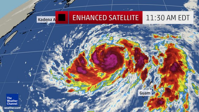
Typhoon Phanfone has pushed past the Mariana Islands and is poised to become a powerful typhoon in the days ahead, posing a threat to Japan this weekend.

Phanfone pushed through the northern Mariana Islands north of Guam Tuesday night as a tropical storm. High surf advisories continue for Guam, Rota, Tinian and Saipan through Friday night, where 7 to 9 foot surf is expected, particularly on west and south-facing reefs.

Typhoon Phanfone is now in a favorable environment of low wind shear and high sea-surface temperatures as it continues to track toward the northwest.

This should allow it to strengthen into a powerful typhoon later this week. A cycle of rapid intensification could occur, given the favorable environmental conditions. As a result, the U.S. military's Joint Typhoon Warning Center forecasts Phanfone to become the equivalent of a Category 4 tropical cyclone on the Saffir-Simpson Hurricane Wind Scale later this week.

Cloud Lightning

Newly born Tropical Storm Phanfone triggers warnings in Northwestern Pacific

Image
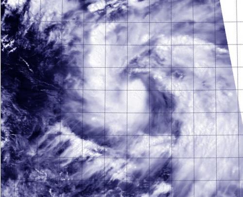
© NASA Goddard MODIS Rapid Response TeamThe MODIS instrument aboard NASA's Aqua satellite took this visible image of Tropical Storm Phanfone in the Northwestern Pacific, on track for the Northern Marianas Islands.
NASA's Aqua satellite passed over newborn Tropical Storm Phanfone on Sept. 29 and captured a picture of the storm that showed thunderstorms wrapped tightly around the storm's center, and a large band of thunderstorms spiraling into the center from the east. Phanfone is now a threat to various islands and warnings are in effect.

A tropical storm Warning is in effect for Saipan, Tinian, Pagan and Alamagan. In addition, a typhoon watch is in effect for the northern Marianas Islands, including Pagan and Alamagan.

The Moderate Resolution Imaging Spectroradiometer (MODIS) aboard Aqua provides visible and infrared images of storms, oceans and land features.

On Sept. 29 at 11 a.m. EDT (1500 UTC) Phanfone had maximum sustained winds near 40 knots (46 mph/74 kph). It was centered near 13.8 north latitude and 149.6 east longitude, about 270 nautical miles east-southeast of Saipan. Phanfone is moving to the west-northwest at 11 knots (12.6 mph/20.3 kph).

Windsock

Two powerful storms to lash Central U.S.

Image
With the autumn season now here, the strength and number of powerful storm systems will be on the increase.

This week will feature two powerful autumn storm systems, one through the middle of the week and another towards the end of the week.

As the jet stream strengthens and dips farther south, the clashes between warm and cold air become more frequent. As a result, the potency of low pressure systems increase.

Tens of millions will be impacted by these storm systems this week, with the risks ranging a wide spectrum.

First Storm System Targets Central U.S.

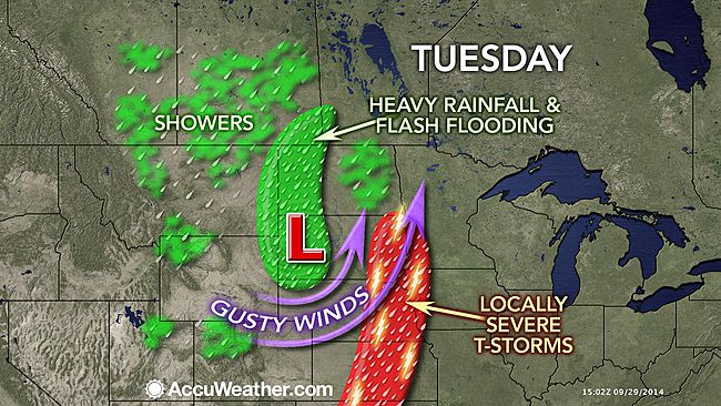
The first storm will take shape across the High Plains and into the central portion of the United States as the energy that brought flooding downpours and severe weather to the Southwest shifts to the northeast.

Folks from eastern Montana to Wisconsin and south to Oklahoma will be impacted by this storm as it passes through the Plains.

Cloud Precipitation

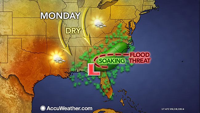
Heavy rain, flooding to target Deep South to Carolinas

Image
Umbrellas and rain jackets will be put to good use over the next couple of days in the Deep South to the Carolinas.

An upper-level disturbance, aided by abundant gulf moisture, will slowly pass over the region through Tuesday.

According to AccuWeather.com Meteorologist Bob Smerbeck, the weather set-up will feature a rather wet couple of days.

"Deep tropical moisture will fuel a developing low pressure system over the Deep South, resulting in heavy rain across the region," said Smerbeck.

Rain and thunderstorms will spread along the Gulf Coast from Louisiana to Florida and eventually to the Carolinas Monday into Tuesday.

Some of the rain could turn rather heavy at times, with rainfall rates approaching an inch per hour in some spots.

"The rain will be heavy enough to cause flash flooding in some locations," added Smerbeck.

Attention

Southern France put on maximum storm alert, risk of flash-flooding

south france storms
© Agence France-Presse/Philippe HuguenNasty storms in southern France have prompted the country's top weather warning
Residents in the Hérault department on the Mediterranean coast were under a red alert on Monday because of storms heavy rain just two weeks after four people were killed by raging flood waters in the area.

Downpours since midday on Monday left local authorities concerned enough about the risk of flash flooding that they put out the red alert, which warns people they are facing an exceptional danger.

They are concerned the river Lez, the main waterway in the Hérault department will burst its banks.

According to reports 95mm of rain fell between midday and 4pm in parts of Hérault on Monday.

The rains have forced officials to shut down trams in Montpellier and certain sections of roads and motorways are blocked due to flooding.

Comment: Montpellier today:
Image
© iambigmax.com


Windsock

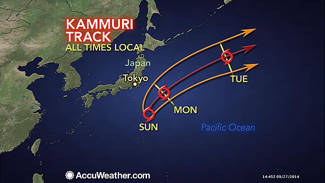
Tropical Storm Kammuri to batter Japan with rain, rough surf, wind

Image
Tropical Storm Kammuri has gradually become more organized during the past several days. The system began early this past week as a weak area of low pressure that produced showers and thunderstorms near the Mariana Islands.

Kammuri is now located to the southeast of Japan and is generally moving to the north. A turn to the northeast is expected Sunday into Monday which will cause the storm to miss Japan. However, Kammuri will still pass close enough to bring a few impacts to the country.

The key factor in the movement of the tropical storm is a fast-moving trough of low pressure that AccuWeather.com meteorologists have been tracking since it was located over 1,000 miles away across Siberia.

Now that this trough is located across eastern Asia, Tropical Storm Kammuri is feeling the effects as the storm is being pulled to the north and eventually the northeast.

As the trough of low pressure continues to interact with Kammuri, effects will become even greater which will cause Kammuri to accelerate to the northeast across the northern Pacific early this coming week.

Cloud Lightning

Wild weather: Rare lightning, hail strike Napa Valley in California

Napa Valley hail 1
One month after an earthquake struck the Napa area, the region was pounded by an incredibly rare hailstorm Friday afternoon. Heavy rainfall and lightning were also reported throughout the North Bay.

A viewer in the Napa County community of Browns Valley took video of hail covering the ground like snow.

KPIX 5 meteorologist Paul Deanno reported six inches of hail in the Napa area. Children were seen making snow angels and had snow fights with the hail.

"It was nothing but rain, then all of a sudden it comes down. It was complete hail for a good to 20 to 25 minutes," said Paul Frommelt of Napa. "In the 49 years I've lived here, I've never seen anything like this ever."