Volcanoes
S


Bizarro Earth

Hawaii's Kīlauea Volcano alert level raised to Warning level

Image
© USGS

Current Volcano Alert Level: WARNING


Current Aviation Color Code: ORANGE

Volcanic Activity Summary: The June 27th flow remains active with a narrow flow moving about 30 m (100 ft) ahead of the previously stalled flow front and lava breakouts occurring from the lava tube about 8 km (5 mi) behind the flow front near where lava entered a crack system on August 18. The narrow flow front moved about 75 m/day (245 ft/day) since September 29, overtaking the stalled flow front during the past 24 hours. The leading edge is 2.3 km (1.4 miles) upslope from Apa'a St. and 3.3 km (2.1 mi) from Pāhoa Village Road, and approximately 16.4 km (10.2 miles) straight-line distance from the vent. Because this flow is moving very slowly and lava discharge from the vent remains low, we do not offer a projection of its future movement. Our next overflight is scheduled for Friday.

Pāhoa town is in the Puna District of the County of Hawai'i.

Recent Observations:
[Lava flow] A narrow flow has moved about 30 m (100 ft) past the stalled flow front in the past 24 hours. This flow has moved about 150 m (490 ft) since September 29.

Hazard Analysis:
[Lava flow] The June 27th lava flow from Pu'u 'Ō'ō vent is active with fresh lava being supplied to the flow front. The flow is slowly advancing downslope toward Pāhoa town.

Bizarro Earth

Volcanic eruption 1,200 years ago scattered ash from Alaska to Europe

Image
Microscopic image of a sample of White River Ash from the Yukon. The picture is of a polished surface of the pumice grains mounted in epoxy, which is how the samples are prepared for analysis.
A new study led by University of Alberta researchers has shown that a volcanic eruption 1,200 years ago scattered ash from Alaska to Europe - a discovery that will help researchers understand how future eruptions could affect the world.

Britta Jensen and Duane Froese in the U of A's Faculty of Science led the research, which showed that a distinct deposit of white, sand-sized grains of volcanic ash visible just below the modern forest floor over much of the Yukon and southern Alaska is present not only near the originating Mount Bona-Churchill in Alaska, but also in the Greenland Ice Sheet and across northwestern Europe.

The deposit, commonly known as the White River Ash, is so prominent that locals sometimes refer to it as "Sam McGee's Ashes" in reference to the Robert Service poem.

As part of the study, samples of the White River Ash, along with ash previously assumed to be from Iceland, were gathered from northern Canada, eastern North America, Greenland, Northern Ireland and Germany. By comparing characteristic features of these samples, the researchers showed that all of the ash originated from the same large prehistoric volcanic eruption in Alaska about 1,200 years ago.

Phoenix

Mount St. Helens shows signs of reawakening

Mt Saint Helens
© Susan Wyatt
Ten years ago this week, Mount St. Helens awoke from an 18-year geological slumber.

The news media and volcano-watchers flocked to Johnston Ridge, the closest road with a crater view. Steam and ash eruptions shot thousands of feet into the air, and for several weeks, the area near the volcano was closed because of safety concerns.

Over the next three years, a second lava dome slowly appeared in the crater, eventually rising 1,076 feet above the crater floor. By the time the eruption ended in 2008, climbers had already been allowed back to the summit and media attention faded.

Though the mountain isn't getting as much publicity these days, scientists with the U.S. Geological Survey are marking the anniversary to highlight new eruption warning technology they've installed around the volcano since then and to remind people that Mount St. Helens will continue to rebuilt itself.

The eruption that started a decade ago was the second of two dome-building phases.

The first one started after the explosive eruption of May 18, 1980. Twenty lava eruptions occurred over the next six years.

Geologists were surprised that the mountain stopped erupting in 1986. "Many of us were expecting it to continue a while," said USGS seismologist Seth Moran.

Bizarro Earth

Signs of activity surface at Mount St. Helens as 10th anniversary of last eruption nears

Mount St. Helens
© ThinkstockThe snow-capped crater of Mount St. Helens.
Ten years ago Wednesday, Mount St. Helens in Washington erupted after being quiet for nearly two decades, and now US Geological Survey (USGS) scientists are concerned that the volcano could mark the occasion by becoming active once again, various media outlets reported over the weekend.

The volcano reawakened in September 2004 and erupted on October 1, remaining active until late January 2008, according to the USGS. That event began with relatively small ejections of ash, which were followed by over three years of continuous slow lava extrusion - a stark contrast to the catastrophic May 1980 eruption that killed 57 and caused over $1 billion in damage.

"Since that time, scientists have been heavily monitoring the area to pinpoint when the next eruption will take place," said Tara West of Inquisitr News. Experts expect "future dome-building eruptions at the volcano," and while they are uncertain exactly when that could occur, Mount St. Helens is starting showing signs of activity, she added.

Cloud Lightning

More than 30 people believed dead at Japanese volcano

Image
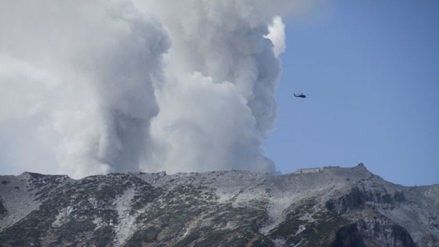
© AP Photo/Koji UedaSeptember 28, 2014: A military helicopter, aiding in rescue operations, flies above Mount Ontake as it continues to erupt in Nagano prefecture. Military helicopters plucked several people from the Japanese mountainside Sunday after a spectacular volcanic eruption sent officials scrambling to reach many more injured and stranded on the mountain.
The bodies of more than 30 people believed to be dead have reportedly been discovered near the summit of an erupting volcano in central Japan.

A police official from Nagano prefecture told the Associated Press that the victims were not breathing and their hearts had stopped, which is the the customary way for Japanese authorities to describe a body until police doctors can examine it. The official added that the exact location where the bodies were found and the identities of the victims were not immediately known. He spoke on condition of anonymity because he wasn't authorized to speak publicly.

Bizarro Earth

The Geoscience behind the Mt. Ontake eruption

The eruption started at 11:53 am Saturday local time. A live webcam installed at Takigoshi captured a pyroclastic flow chasing down the south face of the volcano. Japan Broadcasting Corporation NHK released aerial video of the eruption available here, another video including people on a ridge with the glowering ash tower, and a different vantage point before aerial footage here:


Japan is at a triple-plate subduction boundary between the Eurasian continental plate and the Philippine and Pacific oceanic plates. As the denser oceanic plates dive below the low-density continental plate, water from the saturated sediments lowers the melting point of surrounding rock. That magma feeds a range of volcanoes mirroring the plate boundary.
Image
© Volcano World

Bizarro Earth

Update - Mammoth Lakes earthquakes now exceed 1059 in latest seismic swarm

Image
The Long Valley Caldera is experiencing a large seismic swarm. As magma moves through the earth, it displaces and fractures rock along the way. This movement causes earthquakes that can be recorded with seismometers at the surface of the earth. Seismic monitoring is the most used technique for volcano surveillance. Volcanic earthquakes often provide the initial sign of volcanic unrest. Their signals differ from typical, tectonic, earthquakes because they tend to be found at depths shallower than 10 km, are small in magnitude (< 3), occur in swarms, and are restricted to the area beneath a volcano. Harmonic tremor, or volcanic tremor, is the name for the continuous, rhythmic seismic energy associated with underground magma movement. At Long Valley Caldera, there are currently 61 seismometers that make up the seismic network used to determine earthquake location and energy of movement with time.
Image
The first instrument was installed in 1974 and additional instruments were added throughout the 1980s and 1990s. Between 2000 and 2003, the seismic network was updated to include additional, more modern instruments. More than 200 more earthquakes have erupted in the area in a 24 hour period. Additionally, some earthquakes were now reported at shallower depths. Rodger Wilson, who is following this area for tens of years, hasn't seen this activity since the 1990′s! We have the impression however that the frequency of the earthquakes has seriously declined the last couple of hours. The seismicity at Mammoth Lakes California has even increased compared to this morning. Below all earthquake epicenters during the last 24 hours. Depth of the hypocenters still at +10 km. Earthquake swarms are a regular phenomenon at Long Valley but nobody knows where the magma will move next. We will have to wait and see if this latest swarm indicates a massive movement of magma and might be an early-warning sign that Long Valley might be moving towards an eruption. The last eruption at the volcano is said to have occurred 700,000 years ago and is long over-due. - ER, USGS, TEP

Comment: Nearly 3 dozen small quakes in 24 hours - Volcanic unrest at Mammoth Lakes?


Alarm Clock

Japan's Mt. Ontake volcano suddenly violently erupts - seven people unconscious, eight seriously injured and more than 250 stranded on the mountain

Mount Ontake
© Reuters/KyodoSmoke rises from Mount Ontake, which straddles Nagano and Gifu prefectures September 27, 2014.
A volcano in central Japan has erupted, sending ash clouds down the mountains' slope for more than 3 kilometers. At least eight people have been injured and aircraft have been forced to divert to avoid the dangerous area.The Ontake volcano on the border of Nagano and Gifu prefectures, 200 kilometers west of Tokyo, started erupting at about 11:53 local time (02:53 GMT), NHK reported, citing Japan's Meteorological Agency.

NHK released a video showing the volcano spewing thick, gray smoke into the air."Seven people were slightly injured and one person suffered serious injuries as a result of the eruption," Makoto Hasegawa of the Nagano prefecture fire department told Reuters."Airplanes are diverting their flying routes to avoid the ash cloud," he added.


Bizarro Earth

Nearly 3 dozen small quakes in 24 hours - Volcanic unrest at Mammoth Lakes?

Image
© Wally Skalij / Los Angeles TimesIn this 2012 photo, runners take to a trail in the Mammoth Lakes region in California's Eastern Sierra.
Nearly three dozen earthquakes have rattled the Mammoth Lakes region in less than 24 hours as the area continues to experience ripple effects of "volcanic unrest," according to the U.S. Geological Survey. The temblors -- all between magnitude 2.5 and 3.8 -- have struck since 9 a.m. Thursday, with the latest recorded at 1:49 a.m. Friday, according to the USGS. The 3.8-quake occurred at 9:21 p.m. with an epicenter six miles from Mammoth Lakes.

Heightened earthquake and ground uplift activity have been measured at Mammoth Mountain and the Long Valley Caldera over the last few decades. At 11,053 feet, Mammoth Mountain in California's Eastern Sierra is a lava dome complex on the southwest rim of Long Valley Caldera, although eruptions haven't occurred for some 57,000 years. The recent swarm of quakes in and around the mountain is being tied to recent "volcanic unrest" marked by gas emissions, tree die-offs and intrusions of upward-moving sheets of rock, according to the USGS.

USGS data for recent quakes

Bizarro Earth

U.S. Geological Survey decides to keep a closer eye on the slumbering giant Glacier Peak volcano

Image
Glacier Peak, elevation 10,541 feet, behind Image Lake in Washington state's Glacier Peak Wilderness
The U.S. Geological Survey has decided to keep a closer eye on the slumbering giant in Snohomish County's wild, scenic back yard. A new study is under way for Glacier Peak, one of the most dangerous but least monitored volcanoes in the country.

Scientists are working to map Glacier Peak and the valleys and peaks to the west - about 482 square miles total - using Light Detection and Ranging, or LiDAR. The technology allows them to get an accurate lay of the land even in remote, heavily forested areas, said Jim Vallance, a research geologist with the Cascades Volcano Observatory.

This helps researchers examine past eruptions, prepare for future volcanic activity and determine the best locations for installing real-time monitoring systems.

The USGS National Volcano Early Warning System classifies Glacier Peak as a "very high threat" volcano, on par with Mount St. Helens or Mount Rainier. The St. Helens eruption in 1980 killed 57 people, destroyed hundreds of homes and wiped out at least 47 bridges and 185 miles of highway.

A large eruption of Glacier Peak could send a deadly wall of mud, rock and glacial melt barrelling through parts of the Stillaguamish and Skagit valleys. These catastrophic flows, called lahars, form the land on which Darrington, a town of about 1,400, sits today. Parts of Arlington and Stanwood might lie in the path of a lahar. Scientists also suspect that Burlington, Sedro-Woolley and Lyman in Skagit County are built on top of debris laid down by Glacier Peak's mudflows tens of thousands of years ago.