Earthquakes
S


Radar

Powerful earthquake hits off northeastern Taiwan; no reports of casualties or damage

Image
© Agence France-Presse
A powerful earthquake has struck off northeastern Taiwan, but there were no immediate reports of casualties or damage.

Taiwan's Central Weather Bureau says the quake registered magnitude 6.5, while the U.S. Geological Survey puts it at 5.5.

The earthquake struck Sunday morning at sea, about 88 miles (141 kilometers) east of the Taiwanese county of Keelung. Keelung is about 17 miles (28 kilometers) east of the capital, Taipei.

Earthquakes frequently rattle Taiwan, but most are minor and cause little or no damage.

However, a magnitude-7.6 earthquake in central Taiwan in 1999 killed more than 2,300 people.

Source: The Associated Press

Bizarro Earth

Near the Coast of Central Peru - Earthquake Magnitude 6.9

Peru Quake_281011
© USGSEarthquake Location
Date-Time
Friday, October 28, 2011 at 18:54:33 UTC

Friday, October 28, 2011 at 01:54:33 PM at epicenter

Time of Earthquake in other Time Zones

Location
14.515°S, 76.009°W

Depth
23.9 km (14.9 miles)

Region
NEAR THE COAST OF CENTRAL PERU

Distances
51 km (31 miles) SSW of Ica, Peru

112 km (69 miles) S of Chincha Alta, Peru

201 km (124 miles) W of Puquio, Peru

288 km (178 miles) SSE of LIMA, Peru

Radar

Magnitude-6.9 Earthquake Rattles Peru Coast

Image
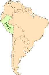
© UnknownMap indicating Peru's location on a map of S. America.
Lima - A magnitude-6.9 earthquake centered off Peru's central coast sent people running panicked into the streets Friday in cities badly damaged by a killer quake four years earlier. There were no immediate reports of damage or injuries.

People who had lost loved ones and homes in the earlier quake were badly shaken and some broke into tears.

"It felt like the one in 2007 because it was very strong," Felix Sihuas told RPP radio. He said he was buried under rubble for six hours in the Aug. 15, 2007, quake, which killed 596 people and largely destroyed the town of Pisco.

Friday's quake was considerably less violent in Lima, a city of 8.5 million people some 180 miles (290 kilometers). The capital shook for about 30 seconds in a series of moderate, swaying movements.

The U.S. Geological Survey said Friday's quake was centered 31 miles (51 kilometers) south-southwest of Ica, a provincial capital of about 200,00 people which suffered widespread damage in the 2007 quake. It was at a depth of 21.7 miles (35 kilometers).

Radar

US, California: Magnitude 4.7 Earthquake Shakes Sacramento

Image
According to the United States Geological Survey, a 4.7 magnitude earthquake shook Sacramento late Wednesday night around 11:37 p.m. Did you feel it?

We sure did.

The quake could be felt as far away as Reno, Nevada, according to the USGS website.

The earthquake's epicenter is believed to have originated in Portola, California about 150 miles north east of Sacramento, though, according to the USGS, the official location has yet to be determined.

Fair Oaks Patch Facebook fans were quick to respond to our status update.

"It woke me up," said Fair Oaks native and Ground Zero Board Shop owner Brendan Mohr. "Never felt one before that and lived here for 28 years."

"Yep felt it," said Fair Oaks Patch Facebook fan, Danielle Parker.

Information is still coming in. As more is gathered we'll be sure to update this story.

Bizarro Earth

Iceland's Katla Volcano Rattled by Double Swarm of Tremors

Image
Iceland's Katla volcano was hit by two swarms of tremors today. The strongest of the first cluster of small harmonic tremors which rattled the glacier was of a 2.9 magnitude.

A second, more intense swarm of tremors erupted shortly thereafter; including two 3.0 magnitude tremors - one inside the caldera of the volcano and one erupted on the parameter under the Mýrdalsjökull glacier.

Unrest at Katla has been intermittent but almost continuous since April. Geologists are monitoring activity at the volcano closely for any changes which could produce a hazardous flood-threat scenario for people living within the vicinity of the summit.

Bizarro Earth

India: 9 aftershocks rattle Sasan Gir region

With quake aftershocks continuing to rattle Junagadh, residents are experiencing a jittery Diwali. On Wednesday, as many as nine earthquake aftershocks were reported from the Sasan Gir area in the district.

According to Institute of Seismological Research (ISR), Gandhinagar, the tremors had a magnitude of 0.8 to 1.7 on the Richter scale. All nine aftershocks were reported 10-13 km south-east of Sasan Gir.

People are still spending sleepless nights in Junagadh region, which had experienced an earthquake measuring 5.3 on the Richter scale on October 20. "Even a small tremor is scaring us these days. People rush out of their homes the moment they feel the earth shaking. However, people here now know that these are aftershocks and not earthquake,'' said Mensi Sariya, a resident of Talala town in Junagadh district.

Bizarro Earth

Fiji Region - Earthquake Magnitude 6.0 - 27th Oct

Fiji Quake_271011
© USGSEarthquake Location
Date-Time
Thursday, October 27, 2011 at 00:15:25 UTC

Thursday, October 27, 2011 at 12:15:25 PM at epicenter

Time of Earthquake in other Time Zones

Location
17.914°S, 179.424°W

Depth
611.9 km (380.2 miles)

Region
FIJI REGION

Distances
208 km (129 miles) SE of Lambasa, Vanua Levu, Fiji

230 km (142 miles) E of SUVA, Viti Levu, Fiji

312 km (193 miles) NNW of Ndoi Island, Fiji

2177 km (1352 miles) NNE of Auckland, New Zealand

Attention

Costa Rica: 4.0 Quake Shakes Area Around The Barva Volcano

Barva volcano map 2
An earthquake registering 4.0 on the Richter scale shook the area of Sarapiqui, Vara Blanca and Venecia on Sunday.

The Observatorio Vulcanológico y Sismológico de Costa Rica (OVSICORI) - national volcano and seismology observatory - reported the epicentre 10 kilometres north of the Barva volcano, with a depth of 7.5 kilometres, caused by a local fault.

In January 2009, a 6.2 earthquake in Vara Blanca, in between the Barva and Poás volcanoes claimed the lives of 13 people.

Bizarro Earth

Eastern Turkey - Earthquake Magnitude 6.0

Turkey 2ndQuake_231011
© USGSEarthquake Location
Date-Time:
Sunday, October 23, 2011 at 20:45:37 UTC

Sunday, October 23, 2011 at 11:45:37 PM at epicenter

Time of Earthquake in other Time Zones

Location:
38.555°N, 43.161°E

Depth:
9.8 km (6.1 miles)

Region:
EASTERN TURKEY

Distances:
20 km (12 miles) WNW of Van, Turkey

120 km (74 miles) NNW of Hakkari, Turkey

129 km (80 miles) S of Agri (Karakose), Turkey

904 km (561 miles) E of ANKARA, Turkey

Bizarro Earth

Eastern Turkey - Earthquake Magnitude 7.2

Turkey Quake_231011
© USGSEarthquake Location.
Date-Time:
Sunday, October 23, 2011 at 10:41:21 UTC

Sunday, October 23, 2011 at 01:41:21 PM at epicenter

Time of Earthquake in other Time Zones

Location:
38.628°N, 43.486°E

Depth:
20 km (12.4 miles) set by location program

Region:
EASTERN TURKEY

Distances:
16 km (9 miles) NNE of Van, Turkey

118 km (73 miles) N of Hakkari, Turkey

127 km (78 miles) SSE of Agri (Karakose), Turkey

929 km (577 miles) E of ANKARA, Turkey