Earthquakes
S


Bizarro Earth

Magnitude 5.5 earthquake rattles Crete

earthquake in Crete
A 5.5 magnitude earthquake has hit northeast of the island of Crete, Greece, according to a preliminary reading by the US Geological Survey.

The tremor struck at 1:34 am local time on Saturday, with the epicenter located 83 miles (133 km) ENE of Iraklion, Crete, Greece.

There are no reported casualties but the quake was strong enough to worry locals in Crete and the neighboring Greek islands.

Earthquakes have historically caused widespread damage across central and southern Greece, Cyprus, Sicily and other neighboring regions. Last year a series of strong earthquakes on the island of Kefalonia damaged hundreds of homes and injured more than a dozen people.

Attention

4.9 magnitude earthquake hits off Vancouver Island, BC

Image
© Natural Resources Canada
The U.S. Geological Survey says a moderate earthquake struck west of Vancouver Island.

The magnitude 4.9 temblor hit Wednesday about 12:22 p.m. about 90 miles southwest of Port Hardy, British Columbia.

Port Hardy Mayor Hank Bood says the quake was not felt in his community on northern Vancouver Island.

Natural Resources Canada says there were no reports of damage, and none was expected. No tsunami warning was issued.

Bizarro Earth

Magnitude-6.4 earthquake rocks Northern Chile

Putre Quake_230315
© USGS
A major earthquake struck early Monday morning in northern Chile.

The National Seismological Service at the University of Chile initially listed the temblor at a magnitude-6.3. The U.S. Geological Survey listed it as a magnitude-6.4.

The temblor's epicenter was located 48 kilometers (30 miles) east-southeast of Putre, Chile, at a depth of 128 km (180 miles), the USGS reported. It was near the borders with Peru and Bolivia, and occurred at 12:51 a.m. local time.

There were no immediate reports of injuries or damage from the region.

No tsunami was expected as a result of the earthquake, according to the Chilean Navy Hydrographic and Oceanographic Service.

The earthquake was felt in Tacna, Peru, but it didn't affect the electrical system, according to the USGS and Twitter users.

Bizarro Earth

Mexico City shaken by earthquake that struck more than 100 miles away

Mexico City locals flooded the streets after the quake
© ReutersMexico City locals flooded the streets after the quake
An earthquake that caused buildings to sway and forced people to flee onto the streets in the Mexican capital happened more than 100 miles away.

The quake hit at 4.30pm local time in the state of Puebla near Tulcingo del Valle - around 100 miles away from Mexico City.

But residents of the faraway capital were forced to flee shaking buildings.

The city is vulnerable to distant earthquakes because much of it sits atop the muddy sediments of drained lake beds that iggle like jelly when quake waves hit.

Mexico City Mayor Miguel Angel Mancera said many evacuations were reported in the capital but officials received no reports of damage or injuries.

The quake had a depth of 31 miles.

A magnitude-8.1 quake in 1985 that killed at least 6,000 people and destroyed many buildings in Mexico City was centered 250 miles away on the Pacific Coast.

Bizarro Earth

USGS: Earthquake Magnitude 6.2 - 82km NNW of Talcahuano, Chile

Talcahuano Quake_180315
© USGS
Event Time
  1. 2015-03-18 18:27:28 (UTC)
  2. Times in other timezones
Nearby Cities
  1. 82km (51mi) NNW of Talcahuano, Chile
  2. 83km (52mi) NW of Tome, Chile
  3. 91km (57mi) NW of Penco, Chile
  4. 96km (60mi) NNW of Concepcion, Chile
  5. 400km (249mi) SW of Santiago, Chile
Scientific Data

Bizarro Earth

USGS: Earthquake Magnitude 6.2 - 134km NW of Kota Ternate, Indonesia

Ternate Quake_180315
© USGS
Event Time
  1. 2015-03-17 22:12:28 (UTC)
  2. Times in other timezones
Nearby Cities
  1. 134km (83mi) NW of Kota Ternate, Indonesia
  2. 136km (85mi) NW of Ternate, Indonesia
  3. 151km (94mi) E of Bitung, Indonesia
  4. 165km (103mi) W of Tobelo, Indonesia
  5. 1083km (673mi) SW of Koror Town, Palau
Scientific Data

Bizarro Earth

Magnitude 6.3 earthquake strikes Papua New Guinea

papua new guinea earthquake
A magnitude 6.3 earthquake struck off the Papua New Guinea island of New Britain on Monday, the U.S. Geological Survey (USGS) said.

The quake struck 6 miles (9 km), northwest of the town of Rabaul, on the northeast tip of New Britain island, it said. There were no immediate reports of any damage or casualties.

Bizarro Earth

U.S. Geological Survey reports earthquake in western North Carolina

Image
The U.S. Geological Survey has reported an earthquake that shook part of Swain County late Friday night.

The U.S.G.S. tracked the earthquake to Cherokee and said it happened at 11:51 p.m.

According to the U.S.G.S. website, this was a 2.8 magnitude earthquake.

Bizarro Earth

More big earthquakes coming to California, forecast says

Earthquake
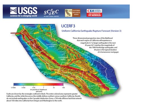
© USGSA 3D view of the likelihood that a magnitude-6.7 earthquake will hit in the next 30 years. Larger image here.
A new view of California's earthquake risk slightly raises the likelihood of big earthquakes in the Golden State, but lowers the chance that people in some regions will feel shaking from smaller, magnitude-6.7 quakes.

The new report does not predict when or where earthquakes will strike, nor how big the next quake will be; instead, it provides a better sense of how often earthquakes will occur and how likely faults are to break in the next three decades. This information helps set earthquake insurance rates and building codes in California.

Under the new forecast, the likelihood of a magnitude-8 earthquake in the next 30 years has increased from about 4.7 percent to 7 percent. A magnitude-8 quake would be twice as strong as the devastating 1906 San Francisco earthquake, a magnitude 7.8.

Meanwhile, the analysis said that Californians should expect a magnitude-6.7 quake to occur every 6.3 years somewhere in the state, which is less than the estimate of every 4.8 years from the previous forecast, released in 2007.

According to the new model, magnitude-8 earthquakes are still exceedingly rare in California. An earthquake of that size would require an extraordinarily long break along the San Andreas Fault, something that may happen only every 500 years.

"The model is probably good news for a homeowner, because they are more threatened by a small, local earthquake than a big, rare, distant earthquake," said Ned Field, lead author of the report and a U.S. Geological Survey research scientist in Golden, Colorado.

But earthquake insurance rates and building codes may change to reflect the uptick in great earthquakes, Field said. A magnitude-8 earthquake triggers long and fast shaking that is highly damaging to buildings and structures such as bridges.

Bizarro Earth

Evacuations as 6.6 earthquake shakes Colombia capital

Colombia Quake
© Google mapsA screenshot from Google maps.
A magnitude 6.6 earthquake has hit the Colombian capital of Bogota, prompting mass evacuations from the city's buildings. Strong and prolonged tremors sparked panic and a social media storm.

The Colombian Geological Survey reported that the tremors originated from the Santander Department area and were 158 kilometers deep. The earthquake was an estimated magnitude of 6.6.
BOGOTA, Colombia - A Widely Felt Earthquake Has Shaken Colombia's Capital, Swaying Buildings. No Immediate Reports of Damages -AP

— Breaking News (@Breaking911) March 10, 2015
"@monterocnn: Evacúan varios edificios del centro de #Bogotá tras el fuerte sismo http://t.co/tiwRihrVIu pic.twitter.com/cRT7FqJ7m5"

— AdrianaCarolina! (@Cinnamon_Skin22) March 10, 2015
According to the US Geological Survey (USGS), the earthquake was centered about nine miles (14 kilometers) north of Aratoca, which is about 175 miles (280 kilometers) north of Bogota. The epicenter was reportedly 91 miles (147 kilometers) deep. The USGS revised the earthquake's magnitude to 6.2.

No damage or casualties were immediately reported.