Earthquakes
S


Blue Planet

Los Angeles rattles with 3.5 earthquake, 2.5 foreshock

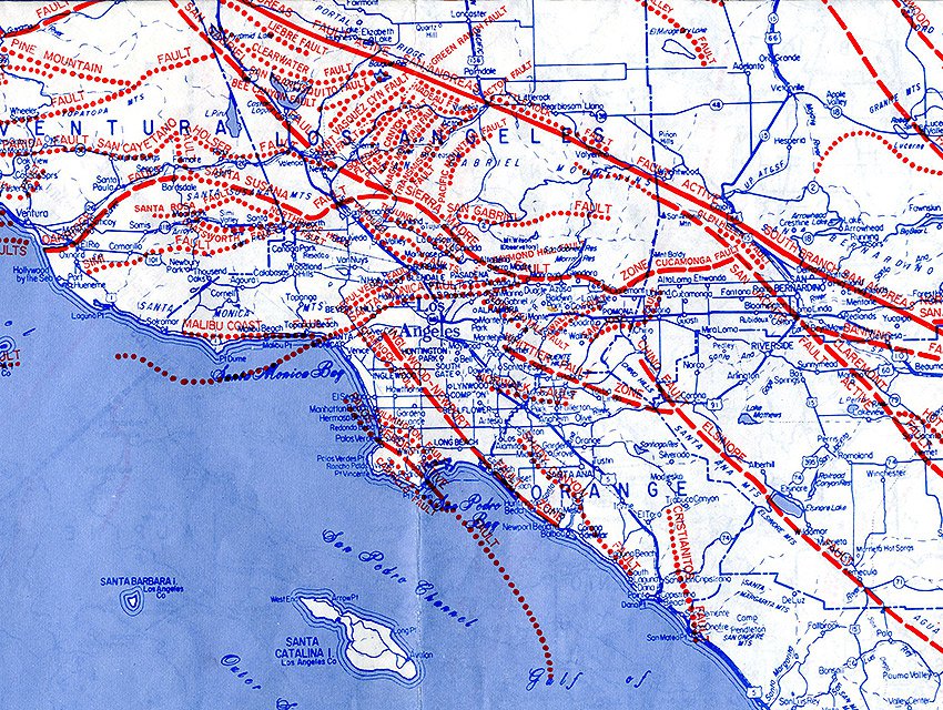
LA faults
© www.lamag.comThe Inglewood-Newport fault is a heavy red line that starts to the left of the word Los "Angeles" in the center of the map.
A magnitude 3.5 earthquake was reported Sunday night about a half mile from View-Park Windsor Hills in South Los Angeles, according to the U.S. Geological Survey. The temblor occurred at 9:17 p.m. Pacific Time and occurred at a depth of 6 miles, according to the USGS.

Although tremors were felt across large swaths of Southern California, the epicenter was located near the Baldwin Hills oil fields and the Kenneth Hahn State Recreation Area, about eight miles west of downtown Los Angeles. The proximity to the oil fields left some to speculate on social media that the earthquake owed to heavy drilling in the area.

But Dr. Lucy Jones, a USGS seismologist, wrote on Twitter that the quake occurred near the Newport-Inglewood fault and at a depth "way below the oil fields." "The focal mechanism matches the Newport Inglewood fault which was producing [earthquakes] long before we were pumping oil," Jones wrote.

The epicenter was about 2,000 feet from that of a magnitude 2.5 earthquake which was reported at 4:35 p.m. The smaller quake was a foreshock that typically precedes larger seismic activity, Jones said. A 1.3 magnitude afterschock occurred at 10:37 p.m.

Comment: Sounds like this quake was a pressure release and fortunately didn't cause casualties or damage. Los Angeles has many geologic faults, any one or more could be triggered at any time.


Moon

4.4 mag earthquake in Sarajevo, several more minor ones in Turkey

Date & time: Sun, 12 Apr 00:05:33 UTC
Magnitude: 4.4
Depth: 10.0 km
Epicenter latitude / longitude: 43.77°N / 18.54°E [Map]
Nearest volcano: Vesuvius (471 km)
Primary data source: GFZ

Comment: There were also several minor earthquakes in Turkey yesterday up to 3.7 mag.


Attention

Major Earthquake activity along the U.S. West Coast, multiple 4.0M+ events at volcanic areas

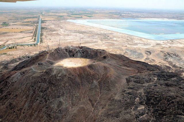
Cerro Prieto
© www.flickr.comCerro Prieto Volcano, Baja, CA
Another magnitude 4.2 earthquake has occurred off the coast of Oregon.

In the past 7 days, up to 2am CDT April 11, 2015, there have been a series of noteworthy earthquakes along the Southern, and Western portions of the North American Craton.

A series of earthquakes began off the coast of Oregon at the fresh undersea lava fields, moving South to the undersea lava fields (and actual volcano) off the coast of Northern California, moving further South to Pisgah Volcano + Red Mountain, then even further South to Cerro Prieto Volcano in Baja California/Mexico border region.

These volcanic locations are VERY old, and have been dormant for eons. To see earthquake activity at these locations means pressure is building in the region for a larger release of energy.

Information on this current 4.2M in Oregon from the USGS

Here is the 4.2M event off the coast of Oregon from April 11 2015

4.7M off the coast of California near the Gorda ridge volcanic fields

4.3M + 4.0M back to back events at Cerro Prieto volcano in Baja

Comment: Cause and effect, rock and roll. If the theories are correct, we have a ticket to ride. The involvement of volcanos and earthquakes come as an interesting pairing with cosmic circumstances and earth changes in the making. The earth's slow-down in rotation can produce devastating effects such as earthquakes and volcanic activity. The immense reservoir of energy stored in the Earth's rotation is susceptible to any change in the rotation rate. Volcanoes sense pressure changes below the lithosphere causing them to vent, which can cause or add to earthquake magnitude.
-Earth Changes and the Human-Cosmic Connection, Pierre Lescaudron


Info

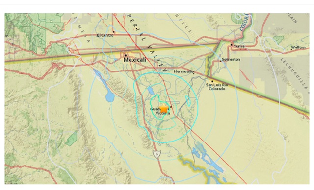
Magnitude 4.5 and 4.2 earthquakes strike Baja, California

An earthquake with a preliminary magnitude of 4.5 struck in Baja California Wednesday, the USGS reported.

The temblor hit at 12:23 p.m., about 4 miles west of Guadalupe Victoria, Mexico, according to the USGS.

Guadalupe Victoria is located in Baja California, about 42 miles away from El Centro, California and 121 miles from San Diego, California.

A second quake, with a preliminary magnitude of 4.2, struck 7 miles east of Guadalupe Victoria less than 10 minutes later, according to the USGS.
Image
© USGS

Bizarro Earth

Magnitude 4.5 earthquake shakes Hawaii island

Image
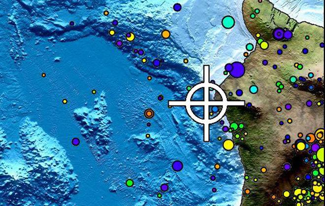
© PACIFIC TSUNAMI WARNING CENTERThis map from the Pacific Tsunami Warning Center shows the location of a magnitude 4.5 earthquake that struck early Sunday morning off Hawaii island. The earthquake did not generate a tsunami.
A magnitude 4.5 earthquake shook Hawaii island early Sunday morning, but no tsunami was generated and there were no immediate reports of serious injuries or damage.

The earthquake struck at 3:23 a.m. about 7 miles west of Kalaoa and 10 miles northwest of Kailua-Kona at a depth of 6.2 miles, the U.S. Geological Survey reported.

Only light shaking was reported and the earthquake caused no detectable changes to the volcanoes on Hawaii island, the Hawaiian Volcano Observatory reported.

The earthquake was widely felt on the Big Island. The USGS "Did You Feel It?" website received more than 150 felt reports, including 3 people who said they felt it on Oahu at Joint Base Pearl Harbor-Hickam and in Aiea.

During the past 30 years, geologists recorded 23 earthquakes, including Sunday's temblor, in the same area offshore of Keahole Point with magnitudes greater than 3.0 and depths of 3 to 9 miles.

The volcano observatory said earthquakes at this depth off the west coast of the Big Island are typically caused by abrupt motion on the boundary between the old ocean floor and the volcanic material of the island and are usually not directly related to volcanic activity.

As of 7 a.m., no aftershocks of the earthquake were reported, volcano scientists said.

Comment: Magnitude 3.3 earthquake reported near summit of Hawaii's Mauna Loa volcano


Attention

A disaster waiting to happen in Oklahoma? The link between fracking and earthquakes is causing alarm in a town where oil storage is 'booming'

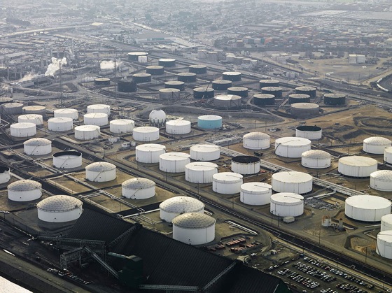
Oil storage tanks in Cushing, Oklahoma
Oil storage tanks in Cushing, Oklahoma, located at the convergence of several pipelines; the number of earthquakes above 3.0 on the Richter scale has risen from a few dozen in 2012 to more than 720 so far this year.
At first glance the small town of less than 8,000 inhabitants looks like typical country America, the kind of place that John Updike might once have written about. Except Cushing, in north-east Oklahoma, is very different.

On top of its human residents, it is also home to about 87 million barrels of oil storage. The biggest ocean-going supertankers carry about two million barrels. The Exxon Valdez spilled less than half that amount when it hit Bligh Reef in Prince William Sound, Alaska, in 1989.

Now, more tanks are being built in Cushing as storage companies seek to increase stocks at lower oil prices.

Dr Riki Ott has seen most oil-related disasters at first hand. A campaigner for energy transportation reform since the Exxon Valdez, she sees the same convergence of risk and lack of preparedness in Cushing that she once saw in Prince William Sound: "It has all of the ingredients for a major disaster. Government and industry officials are misleading the public and hardly anyone knows about it."

The oil is in Cushing because the town sits at the convergence of several of the largest pipelines in the country and has been a hub for oil transportation and storage since the early 20th century.

US oil industry
One of those pipelines is essentially the southern leg of what has come to be known as the Keystone XL, perhaps the most controversial energy development of the last 20 years. In total, there are about 14,000 miles of pipeline in Oklahoma.

Oil is stored in vast quantities at Cushing in above-ground storage containers that litter the fields surrounding the town. This is a place where "oilfield" has nothing to do with drilling, in a state where the oil and gas industry has become as powerful as it is anywhere in the United States.

Now, thanks to fracking, it's also one of the most active seismic areas in the entire United States.


Ironically it is the fracking industry that created this very real and little-discussed threat to Cushing which, according to Oklahoma Sierra Club's director Johnson Bridgwater, has "the potential for producing one of the worst environmental catastrophes in American history".

Until very recently earthquakes were a rare occurrence in Oklahoma. Not any more. In 2008 the US Geological Survey recorded just two earthquakes above 3.0 on the Richter Scale in Oklahoma.

In 2014 it recorded 585, including 15 that measured over 4.0. The state is on target to break through 800 in 2015, taking California's crown as the most active seismic state in the country.

The epicentre of an earthquake on 10 October that measured 4.3 on the Richter Scale just happened to be Cushing.
Comment: The potential disasters resulting from the same "lack of understanding of risk" and "official denial of reality" and the probable causes are getting more 'fracking obvious'!


Attention

Larger, more destructive earthquakes possible given new link between two California faults

Image
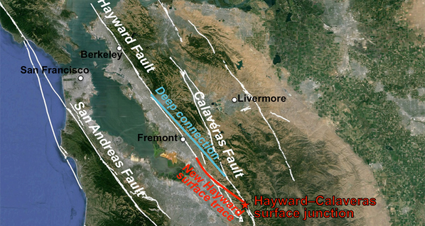
© Estelle Chaussard/UC BerkeleyThe red line indicates the newly discovered link between the southern end of the Hayward Fault and the Calaveras Fault, once thought to be independent systems.
Two California fault lines — the Calaveras Fault and the Hayward Fault — are actually connected, new research shows, meaning an earthquake resulting from the pair could be much more destructive than originally thought, with a potential for a magnitude 7 quake or greater.

Seismologists from the University of California Berkeley used two decades of satellite data to look at "ground deformation" and "fault creep," a news release explained. Creep describes the constant, slow movement of a fault line as opposed to a fault line that's still between quakes, like San Andreas, according to the U.S. Geological Survey. "The Hayward Fault is actively moving, year-by-year," the USGS noted.

However, as Estelle Chaussard, lead researcher from UC Berkeley, explained to weather.com, though the ground is continuously moving, this movement is not producing any earthquakes. Until, that is, there's a rupture.

Comment: The potential for California to have its predicted 'big one' just got a little a bigger!


Attention

Another small earthquake hits southern Los Angeles area

Image
© Lalate
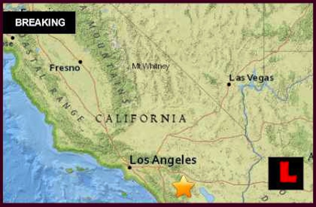
Another Los Angeles area earthquake today 2015 has struck Southern California. This time the quake was centered further south, closer to Anza and La Quinta. Damage assessment is pending. The quake follows another temblor that struck Granada Hills on Saturday.

USGS indicates to news that a Los Angeles area earthquake today April 5, 2015 struck just after 5:56 am PST. The quake was shallow. Reps tell news that the quake started just 8.9 km below ground level. As a result the quake could be felt across the vicinity. The quake registered a 2.6 magnitude. It was seven miles east of Anza, twenty miles south of La Quinta, it was twenty-one miles southwest of Palm Dester and 21 miles south of Rancho Mirage.

Several quakes have been hitting the region since 2012. In April that year one quake was centered near Indio. It was twelve miles north of Coachella, and thirteen miles east of Thousand Palms. It was reportedly twenty miles from Twenty-nine Palms and ninety-four miles from San Diego, news analysts note.

Then in June a 3.5 magnitude earthquake struck centered eight miles east of Coachella. The quake was ten miles outside of Indio and Mecca. The quake was less then twenty-eight miles east of Palm Springs. The quake was also ninety-one miles from San Diego, officials remind news.

Bizarro Earth

Multiple earthquakes shake Los Angeles area over a period of three hours

Image
© USGS
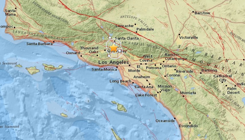
A series of earthquakes, the largest magnitude 3.1, shook the Oat Mountain area north of the San Fernando Valley Saturday.

Automated seismographs reported a series of six quakes, most in the 1-2 magnitude, starting at 7:45 a.m.

The largest quakes were magnitude 2.7 at 7:52 and magnitude 3.1 at 7:54, according to preliminary automated reports that have not been reviewed by humans.

A magnitude 2.0 temblor hit the mountain at 10:14 a.m.

As a precaution, Los Angeles city fire trucks were rolled out of station houses, where garage doors can jam or stall if a major quake occurs.

Seismologists routinely give a 10 percent chance of a major shaker following what turns out to be a foreshock.

Firefighters also scanned bridges and buildings near their station houses, which is the standard drill following a quake. No damage was found.

Persons reported to the USGS that they felt weak shaking in the northern half of the San Fernando Valley, and in across Santa Clarita, and as far away as Westlake Village, Glendale and the Antelope Valley.

Hourglass

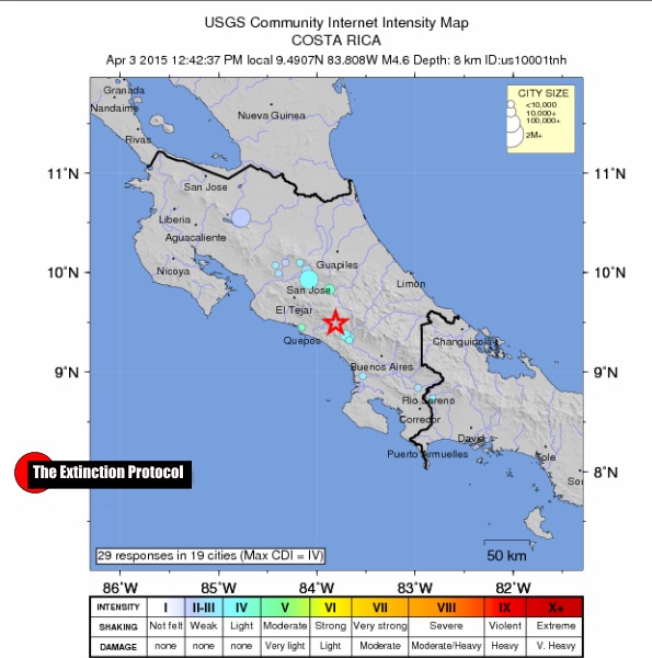
Two Good Friday earthquakes rock southern Costa Rica

A series of earthquakes rocked the southern Costa Rican city of Pérez Zeledón and could be felt in the capital, San José, starting at 12:32 p.m., reported the Volcanological and Seismological Observatory of Costa Rica, OVSICORI.

The first quake had a magnitude of 4.8 with an epicenter some 10 kilometers from Pérez Zeledón. A magnitude-5.2 aftershock at 12:42 p.m. was followed by a magnitude-2.3 temblor at 12:50 p.m., according to initial reports from OVSICORI.

The temblor was strong enough to drive some families out of their homes in Pérez Zeledón and crack the walls of homes in the beach town of Uvita, according to reports received by The Tico Times. Some beachgoers on the Caribbean even felt the quake.
Image

Comment: 4.6 magnitude Costa Rican earthquake produces more than 70 aftershocks