Earthquakes
S


Seismograph

New York City shakes as 4.8 magnitude earthquake hits US north-east

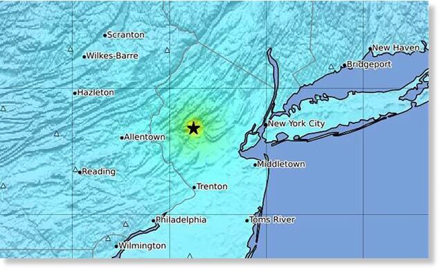
This image provided by US Geological Survey shows the epicenter of an earthquake on the east coast of the US on Friday.
An earthquake shook the densely populated New York City metropolitan area on Friday morning, the US Geological Survey said, with residents reporting they felt rumbling across the eastern seaboard in what is a relatively rare event for the region.

The government agency reported a quake with a preliminary magnitude of 4.8, centered near Lebanon, New Jersey.

People reported feeling the quake in the states of Connecticut and Massachusetts, with the Weather Channel reporting that it was noticeable in Boston and residents in Philadelphia reporting they felt it, too. Tremors lasting for several seconds were felt more than 200 miles away near the New Hampshire border.

The fire department of New York said on Friday there were no initial reports of damage or injury. But city dwellers were shocked and a little shaken up by the unexpected event, during which people sitting at desks or at home in high rises felt their whole building shake mildly for several seconds.

The movement then passed but people were left jittery about aftershocks and busily checking in with friends and family, including children at school, briefly putting a high load onto cellphone networks, the city authorities reported.

The New York police department's deputy commissioner of operations, Kaz Daughtry, said in a statement: "While we do not have any reports of major impacts at this time, we're still assessing the impact."

The UN security council was meeting at its headquarters in New York to discuss the situation in Gaza when the earthquake hit, shaking the building.
Comment: Fox News reports:


Seismograph

6.1 magnitude earthquake strikes eastern Japan

bbbbbbbb
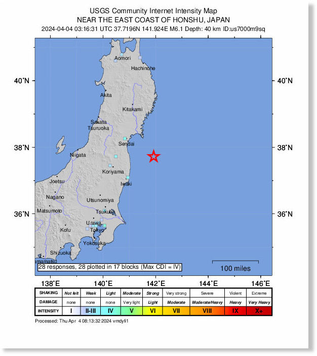
A strong earthquake of 6.1 magnitude shook Japan's Minamisoma region on Thursday, according to the US Geological Survey.

The tremor occurred 83 kilometers (51 miles) east of Minami-Soma in the province of Fukushima at a depth of 40 kilometers, the agency said, with no tsunami warning issued.

There was no report of any damage.

According to Japanese media, the quake was felt in Iwate, Miyagi, and Fukushima provinces at 12.16 p.m. local time (0316GMT), with no abnormalities confirmed at the crippled Fukushima Daiichi nuclear power plant.

This came after a powerful magnitude 7.4 earthquake struck off Taiwan's eastern coast on Wednesday, killing at least nine people, while hundreds others were injured.

The quake was the strongest to have hit the island nation in 25 years. In 1999, around 2,400 people were killed when a 7.7-magnitude earthquake struck Taiwan in the middle of the night.

Seismograph

Shallow magnitude 6.2 earthquake - North Pacific Ocean, off the Northern Mariana Islands

mmmmmm
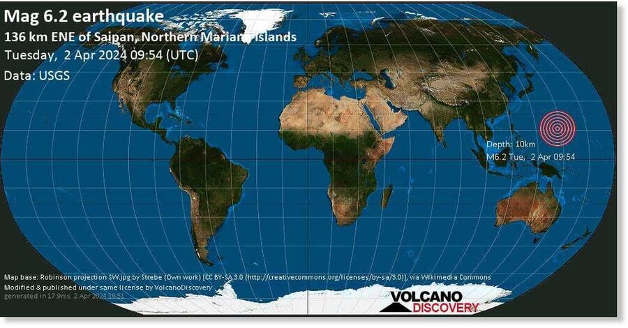
A very strong magnitude 6.2 earthquake occurred in the North Pacific Ocean 128 km (80 mi) from Northern Mariana Islands in the late afternoon of Tuesday, Apr 2, 2024 at 7.54 pm local time (GMT +10). The quake had a very shallow depth of 10 km (6 mi) and was reported felt by some people near the epicenter.

Bizarro Earth

The extraordinary climate events of 2022-24

Hunga Volcano
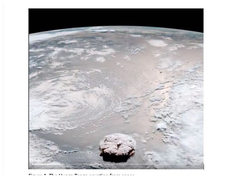
© judithcurry.comFigure 1. The Hunga Tonga eruption from space.
The unlikely volcano, the warmest year, and the collapse of the polar vortex.

The climate events of 2022-24 have been were truly extraordinary. From an unlikely undersea volcanic eruption to the warmest year on record to the collapse of the polar vortex after three sudden stratospheric warming events. This rare convergence presents a unique learning opportunity for climatologists and climate aficionados alike, offering insights into a climate event that may not be repeated for hundreds or even thousands of years.

1. January 2022, the unlikely volcano

Never before have we witnessed an undersea volcanic eruption with a plume capable of reaching the stratosphere and depositing a large amount of vaporized water. This extraordinary event occurred in January 2022 when the Hunga Tonga volcano erupted. The conditions for such an event are rare: the volcano must be deep enough to propel enough water with the plume, but not too deep to prevent it from reaching the stratosphere. Most undersea volcanoes do not produce plumes at all, which makes Hunga Tonga's eruption all the more remarkable.

The Hunga Tonga volcano occupied a unique "sweet spot" at a depth of 150 meters the day before the eruption. In addition, the eruption itself must be exceptionally powerful for water vapor to rise into the stratosphere. The January 2022 eruption of Hunga Tonga was the most powerful in 30 years, since the 1991 eruption of Mt. Pinatubo.

Active undersea volcanoes at the appropriate depth are rare, and the likelihood of one erupting with such intensity is relatively low. We may be looking at an event that occurs once every few centuries, or maybe even once every millennium. Undoubtedly, it was an exceptionally rare event.

While the most powerful eruptions, such as Tambora in 1815, can indeed strongly influence hemispheric weather for a few years, our observations of eruptions such as Agung (1963), El Chichón (1982), and Pinatubo (1991) suggest that their effects dissipate within 3-4 years.

Seismograph

Shallow 6.4 magnitude earthquake southwest of Fiji

nnnnnnn
An earthquake of 6.4 magnitude struck the Suva in Fiji during the early hours of Wednesday (local time), the National Center for Seismology (NCS) reported.

The depth of the earthquake was measured at 10 km and the epicentre was 591 km South-West of Suva in Fiji.

"Earthquake of Magnitude: 6.4, Occurred on 27-03-2024, 06:58:17 IST, Lat: -21.21 & Long: 173.85, Depth: 10 Km, Location: 591km SW of Suva, Fiji," said the NCS in a post on X.

The National Center for Seismology (NCS) is the nodal agency of the Government of India for monitoring earthquake activity.

No casualties have been reported so far. Further details are awaited.

Seismograph

6.9 magnitude earthquake jolts Papua New Guinea - at least three people killed (UPDATE)

mmmmm
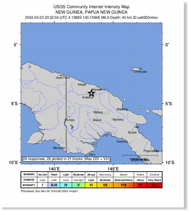
An earthquake of 6.9 magnitude struck a remote part of northern Papua New Guinea in early hours of Sunday (local time), the United States Geological Survey (USGS) reported.

The depth of the earthquake was measured at 35 km and the epicentre was 32 km east-north-east of the small settlement of Ambunti.

No casualties have been reported so far. Further details are awaited.

Earthquakes are common in Papua New Guinea, which sits on top of the seismic "Ring of Fire" -- an arc of intense tectonic activity that stretches through Southeast Asia and across the Pacific basin.

A strong earthquake of 7.0 magnitude killed at least seven people in April last year. (ANI)

Comment: Update March 25

Laprensalatina.com reports:
At least three people have died and almost 100 houses collapsed in a magnitude-6.9 earthquake that shook an area in northern Papua New Guinea that was already flooded by recent torrential rain, according to local media on Monday.

According to the United States Geological Survey (USGS), which monitors seismic activity around the world, the earthquake occurred on Sunday at 06:22 local time (20:22 GMT Saturday) at a depth of 40 kilometers, about 38 kilometers northeast of the town of Ambunti in the province of East Sepik.

The earthquake caused homes to collapse into flooded rivers and claimed the lives of a woman and her daughter in the village of Jikinumbu, and another child in Sotmeri, both in East Sepik, the Papuan newspaper Post Courier reported on Monday.

It also said the earthquake caused the collapse of some 93 homes, as well as bridges and infrastructure essential in this country rich in resources, but with difficult terrain and with almost 40 percent percent of its 10.5 million population living in poverty.

Defense Minister Billy Joseph said in a statement Sunday night that he was waiting for provincial reports on the impact of the earthquake to decide how best to respond.

"We have serious adverse weather conditions; and all emergency services in our country should be on high alert," said the minister, warning of the dangers at sea and the possibility of landslides occurring in an area already devastated by torrential rains.

It is estimated that some 24 people have died in recent weeks due to flooding and landslides in several mountainous and coastal areas of Papua New Guinea, where overflowing rivers have displaced thousands of people and damaged crops and orchards, and contaminated water sources.

Papua New Guinea sits on the Pacific Ring of Fire, an area of great seismic and volcanic activity that is shaken each year by about 7,000 earthquakes, most of them moderate.


Info

2,000 earthquakes in a day off Canada coast suggest the ocean floor is ripping apart, scientists say

Record earthquake activity off the coast of Vancouver Island hints at the birth of new oceanic crust.
Victoria Harbor on Vancouver Island
© Paul Biris via Getty ImagesVictoria Harbor on Vancouver Island, Canada sits near the Juan de Fuca Ridge, where researchers recently measured nearly 2,000 earthquakes in a single day.

Almost 2,000 earthquakes rocked a spot off the coast of Canada in a single day earlier this month, which could be a sign that new oceanic crust is about to be birthed via a deep sea magmatic rupture.

The quakes aren't any threat to people. They're relatively small and centered on a spot called the Endeavour site, about 150 miles (240 kilometers) off the coast of Vancouver Island. This spot hosts a number of hydrothermal vents and sits on the Juan de Fuca Ridge, where the ocean floor is spreading apart. This area is separate from the subduction zone — a region where one tectonic plate is sinking into the mantle underneath another plate — closer to the coast that can create large, destructive earthquakes, said Zoe Krauss, a doctoral candidate in marine geophysics in the University of Washington.

"Mid-ocean ridges aren't actually capable of producing that large of earthquakes, not too far above a magnitude five," Krauss told Live Science. "This is not going to trigger 'the big one' on the subduction zone."

The quakes are interesting scientifically because they can reveal details about how the ocean floor pulls apart and new crust forms, Krauss said. At the Endeavour site, the Pacific plate and the Juan de Fuca plate are pulling apart. This stretching creates long, linear fault lines and thins the crust, enabling magma to rise up. When the magma reaches the surface, it cools and hardens, becoming new ocean crust.

Seismograph

Shallow 6.4 magnitude earthquake hits off Indonesia's Java island

mmmmmm
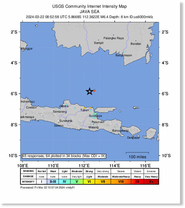
A magnitude-6.4 offshore earthquake hit near Indonesia's Java island on Friday, the United States Geological Survey said, with the tremor felt in the capital Jakarta.

The quake had a depth of approximately eight kilometres (five miles), and struck off Java island's northern coast near Bawean island at about 3:52 pm local time (0852 GMT), the USGS said.

There were no immediate reports of damage or injuries, and no tsunami warning was issued by local authorities.

Indonesia, a vast archipelago nation, experiences frequent earthquakes due to its position on the Pacific "Ring of Fire", an arc of intense seismic activity where tectonic plates collide that stretches from Japan through Southeast Asia and across the Pacific basin.

Seismograph

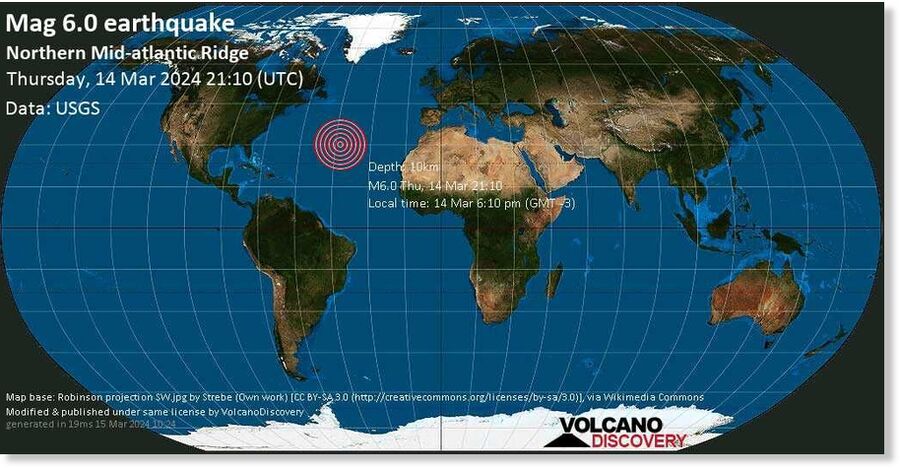
Shallow magnitude 6.0 earthquake - Northern Mid-Atlantic Ridge

MMMMM
EARTHQUAKE DETAILS

Date & time Mar 14, 2024 21:10:25 UTC
Local time at epicenter Thursday, Mar 14, 2024, at 06:10 pm (GMT -3)
Status Confirmed
Magnitude 6.0
Depth 10.0 km
Epicenter latitude / longitude 29.8318°N / 42.6621°WInternational Territory (not near any country)
Seismic antipode 29.8318°S / 137.3379°E Australia
Shaking intensity Strong shaking near epicenter
Felt 7 reports
Primary data source USGS (United States Geological Survey)

Seismograph

6.0 magnitude earthquake hits Papua New Guinea

mmmm
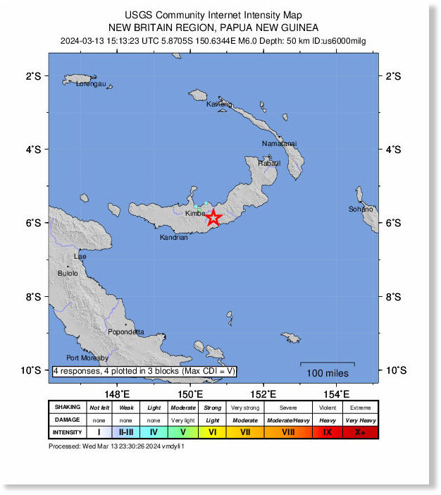
A magnitude 6.0 earthquake hit Papua New Guinea early Thursday, about 65 kilometres southeast of the town of Kimbe, the United States Geological Survey said.

The quake had a depth of approximately 50 kilometres (31 miles), and struck outside Kimbe, in the West New Britain region, at about 1:13 am (1513 GMT Wednesday), the USGS said.