Earthquakes
S


Seismograph

6.9 magnitude earthquake strikes Kermadec Islands

mmmm
An earthquake of magnitude 6.9 struck the Kermadec Islands region in New Zealand on Saturday, the United States Geological Survey (USGS) said.

The quake was at a depth of 152 km (94 miles), USGS said.

The European Mediterranean Seismological Centre earlier estimated the magnitude at 6.6 and a depth at 183 km.

No tsunami warning was issued after the quake, the US Tsunami Warning System said.

Source: Reuters

Seismograph

Vanuatu: Pacific nation reels from twin cyclones and 6.5 magnitude earthquake

mmmmmm
The Pacific nation of Vanuatu has declared a state of emergency as it reels from an earthquake and two cyclones in as many days.

The 6.5 magnitude quake struck on Friday, a day after category four Cyclone Judy swept through the islands.

The storm caused widespread damage and flooding across the country. No casualties have been reported yet.

A category three storm, Cyclone Kevin, arrived on Friday, bringing destructive winds of up to 130km/h (81mph).


Seismograph

6.5-magnitude earthquake strikes off Papua New Guinea

mmmmm
A 6.5-magnitude earthquake hits the Kembe district of Papua New Guinea on Wednesday.

Last Sunday, the US Geological Survey reported that an earthquake measuring 6.5 on the Richter scale had hit Papua New Guinea.

The agency said the quake was detected at 21:24 on Saturday, UTC

The epicenter is located 58 km southeast of Kandrian city. Its source is located at a depth of 65 km.

The US Weather Service Alert System did not report a tsunami risk after the earthquake in Papua New Guinea.

Blue Planet

New study of earthquakes reveals secrets about the earth's fluid mantle

Turkey earthquake
© AP
A new study from a University of Chicago scientist suggests there may be a layer of surprisingly fluid rock ringing the Earth, at the very bottom of the upper mantle.

The finding was made by measuring the lingering movement registered by GPS sensors on islands in the wake of a deep earthquake in the Pacific Ocean near Fiji. Published Feb. 22 in Nature, the study demonstrates a new method to measure the fluidity of the Earth's mantle.

"Even though the mantle makes up the largest part of Earth, there's still a lot we don't know about it," said Sunyoung Park, a geophysicist with the University of Chicago and the lead author on the study. "We think there's a lot more we can learn by using these deep earthquakes as a way to probe these questions."

Seismograph

Fresh 5.6 quake in Yeşilyurt Türkiye

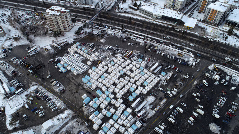
turkey earthquake tents
© Sercan Kucuksahin / Anadolu Agency via Getty ImagesAn aerial view of a tent camp set up in Malatya after the February 8 quakes.
The Turkish emergencies agency AFAD reported a new earthquake in the east, with at least one fatality recorded

A new deadly earthquake hit Türkiye at around midday on Monday, the national disaster relief agency reported. According to preliminary reports, one person has been killed and 69 others injured in the eastern province of Malatya.

The Turkish disaster and emergency management agency AFAD said the tremor measured 5.6 in magnitude, with the epicenter located in the Yesilyurt district. The quake was estimated to have originated at a depth of approximately seven kilometers and could be felt in neighboring provinces, according to the rescue agency.

Comment: Twitter users on the scene:


Seismograph

Magnitude 6.2 quake strikes Papua New Guinea

mmmmmm
A magnitude 6.2 earthquake struck the remote New Britain region of Papua New Guinea today, the United States Geological Survey said, but no tsunami warning was issued.

The quake had a depth of 38km, the USGS said, and was recorded in the sparsely populated West New Britain archipelago region this morning.

The shaking was felt at a Walindi Plantation Resort near the town of Kimbe about 80km from the quake but it was described by a worker as "not too bad".

"No one really reacted, it shook, but no damage," resort worker Vanessa Hughes told AFP.

Source: AFP

Blue Planet

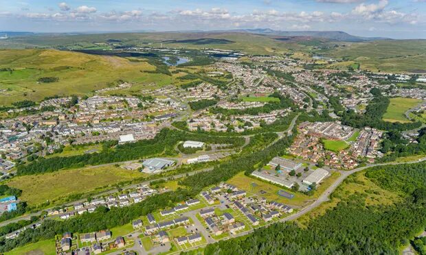
South Wales hit by M3.7 earthquake, 1 month after sinkhole found in same region

wales
Epicentre of quake, which hit just before midnight on Friday, was north of Brynmawr and west of Crickhowell
An earthquake has shaken parts of south Wales.

The British Geological Survey (BGS) said the 3.7 magnitude quake happened at 23:59 GMT on Friday. The epicentre was just north of Brynmawr, Blaenau Gwent and west of Crickhowell, Powys.

It was felt by residents across the region, including Abergavenny, Crickhowell, Llangynidr, Llanover and Llanfoist, with many saying that furniture and windows shook.

Comment: GoogleMaps below shows the epicentre of the quake and the location of the sinkhole, a distance of about 20 miles:

quake sinkhole
For more on the sinkhole, see: UK: Experts are baffled as giant 30ft-wide and 9ft deep sinkhole crater opens just feet from busy road in Wales


Seismograph

6.0 magnitude earthquake off Hokkaido, Japan

mmmmm
6.0 magnitude earthquake 66 km from Kushiro, Hokkaido, Japan

UTC time: Saturday, February 25, 2023 13:27 PM
Your time: Saturday, February 25, 2023 at 1:27 PM GMT
Magnitude Type: mww
USGS page: M 6.0 - 61 km ESE of Kushiro, Japan
USGS status: Reviewed by a seismologist
Reports from the public: 7 people

Attention

Best of the Web: Death toll climbs above 50,000 after Turkey, Syria earthquakes

mmmmmm
The number of people killed by the earthquakes that struck Turkey and Syria earlier this month has now passed 50,000, according to the latest figures from both countries.

In Turkey alone, 44,218 people died as a result of the earthquakes, the country's Disaster and Emergency Management Authority (AFAD) said on Friday, while the latest announced death toll in Syria was 5,914.

The first earthquake on February 6 that hit southeastern Turkey and northern Syria measured a magnitude of 7.7 and a second, a little later, measured 7.6. The region has been rocked by more than 9,000 aftershocks since, according to the AFAD.

Nearly 240,000 rescue workers, including volunteers, continue to work in the 11 quake-hit provinces in Turkey. Some of the areas affected by the quakes were initially difficult to access but recovery efforts continue and casualty numbers are rising as they progress.

There have been no reports of survivors being rescued in recent days.
Seismograph

6.3 magnitude earthquake off Maluku Utara, Indonesia

nnnnnnnn
6.3 magnitude earthquake 177 km from Tobelo, Maluku Utara, Indonesia

UTC time: Thursday, February 23, 2023 20:02 PM
Your time: Thursday, February 23, 2023 at 8:02 PM GMT
Magnitude Type: mww
USGS page: M 6.3 - 177 km N of Tobelo, Indonesia
USGS status: Reviewed by a seismologist
Reports from the public: 0 people