Earthquakes
S


Radar

US, South Carolina: Minor earthquake hits Upstate city

The U.S. Geological Survey says a small 2.3 magnitude earthquake has been reported in the northwestern part of South Carolina.

Minor tremors were felt for a few seconds at 12:27 p.m. Tuesday. No injuries were reported, and area law enforcement agencies said they didn't receive calls from people calling about the tremors.

A geophysicist with the agency, Julie Dutton, says she doesn't think many people would have felt the earthquake.

The earthquake was centered in Gray Court, about 30 miles south of Greenville.

Source: The Associated Press

Radar

US: Small Earthquake Rattles South Dakota's State Capitol

The South Dakota Capitol and other buildings shook briefly Tuesday as a rare earthquake hit the state's capital city.

The U.S. Geological Survey's Earthquake Center confirmed an earthquake with a preliminary magnitude of 3.4 struck about one mile west of Pierre at 2:45 p.m. CDT. There were no immediate reports of damage, but people in the city reported hearing multiple booms and feeling buildings shake.

Eric Stasch, operations manager at U.S. Army Corps of Engineering's Oahe Dam, said an initial check indicated the quake had caused no damage to the massive earthen structure. Officials planned to conduct a more thorough check of the Missouri River dam, located about five miles upstream from Pierre, later Tuesday.

The three motion detectors at the dam were not tripped by the earthquake, Stasch said.

Clock

US, Illinois: Palatine Sinkhole Fix Will Take a While Longer

Image
© Bill ZarsWork continues on the 20-foot sinkhole that formed at Hicks and Dundee roads in Palatine after a torrential rainfall more than two weeks ago.
The two-week time frame officials provided when estimating how long it would take to close the massive sinkhole that formed on Palatine's north side after a 100-year storm hit the area has come and gone.

Fixing the 15-by-20-foot opening at the northwest corner of Hicks and Dundee roads quickly proved complex because of the utilities involved, as well as the discovery of buried bracing material from when the sewer line was originally built, Public Works Director Matt Barry said.

The sinkhole formed July 23 about 30 feet below the surface when a sewer line collapsed in the wake of a torrential downpour - 5.43 inches of rain in three hours.

Barry said he went to the scene Monday and found crews still in the excavating phase, so it's premature to say how much longer repair work will take.

Info

US, Texas: Small Earthquake Reported in Dallas Area

A small earthquake has been recorded in the Dallas area.

A spokesman for the U.S. Geological Survey said the earthquake occurred about 11:45 p.m. Saturday. No injuries were reported.

Geophysicist Paul Caruso told The Dallas Morning News that the late-night quake was a magnitude 2.6.

The epicenter was six miles west-southwest of Dallas, and it was felt as far away as Greenville, according to reports to the agency's Web site.

Caruso said experts "don't expect significant damage or injuries until the magnitude is in the 5.5 range."

Source: The Associated Press

Radar

US: Small Magnitude 3.1 Earthquake Hits Central California

Image
A small earthquake shook a portion of Central California early Sunday morning, the U.S. Geological Survey reported.

The magnitude 3.1 earthquake struck at 2:16 a.m. in a sparsely populated, mountainous area about eight miles northwest of Grapevine, Calif., and 78 miles northwest of downtown Los Angeles, according to the preliminary report of the quake. There are no reports of damage.

Attention

US: 2 Small Earthquakes Rattle Central Oklahoma

Two small earthquakes have shaken the Oklahoma City metropolitan area but there have been no reports of damage.

According to the U.S. Geological Survey, a magnitude 2.0 quake hit about 2:34 a.m. Sunday. It was centered about eight miles southeast of Oklahoma and had a depth of 3.1 miles.

The survey reported another earthquake about 8 a.m. located 13 miles northeast of Norman. That quake had a magnitude of 2.3 and also had a depth of 3.1 miles.

Geologists say earthquakes of magnitude 2.5 to 3 are generally the smallest felt by humans.

Source: The Associated Press

Evil Rays

Unusual earthquake close to Israel and the Gaza strip

Image
© Benq TerranoHadera Israel
An unusual weak coastal earthquake struck the Hadera and Netanya area. The earthquake was felt in Israel and in the Gaza strip.

The current epicenter area can be called as very unusual.

We have NO trace of any historic important earthquakes in the past.

For a lot of people it will be a unique experience.

EMSC reports a magnitude of 4.3 at a depth of 30 km (can be compared as the same intensity as USGS).

Bizarro Earth

Kuril Islands - Earthquake Magnitude 6.3

Kuril Quake_040811
© USGSEarthquake Location
Date-Time:
Thursday, August 04, 2011 at 13:51:36 UTC

Friday, August 05, 2011 at 01:51:36 AM at epicenter

Time of Earthquake in other Time Zones

Location:
48.784°N, 154.835°E

Depth:
49 km (30.4 miles)

Region:
KURIL ISLANDS

Distances:
230 km (142 miles) SSW of Severo-Kuril'sk, Kuril Islands, Russia

542 km (336 miles) SSW of Petropavlovsk-Kamchatskiy, Russia

659 km (409 miles) NE of Kuril'sk, Kuril Islands

1907 km (1184 miles) NE of TOKYO, Japan

Info

US: Magnitude 3.1 Earthquake Recorded in California Desert

Image
A magnitude 3.1 earthquake was recorded Tuesday morning in the California desert of San Bernardino County.

The temblor was centered 15 miles from Boron, 22 miles from Barstow and about 81 miles east of downtown Los Angeles.

There were no reports of damage.

Radar

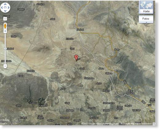
Moderate Earthquake hits Ethiopia

Image
© Google
UPDATE 08:50 UTC : GFZ has revised his earthquake data and has come out with new numbers who are in line with both USGS and EMSC : Magnitude : 4.6 at a depth of 10 km

UPDATE: A potentially dangerous earthquake has hit on the border of Ethiopia and Somalia, early this morning. The earthquake would have been very much felt in the city of Borama and villages nearby.

The USGS has its epicenter directly under Borama.

The huge difference in the estimates of GFZ and USGS show the deficiency of adequate seismological stations in this area of the world (similar to our PNG article).

There are no volcanoes in the immediate vicinity according to CATDAT, so this is most likely a tectonic earthquake in the East Africa rift zone.

A number of earthquakes have occurred in this region previously in 1930, 1951, 1961 and 1980.