Earthquakes
S


Bizarro Earth

Long Valley super-volcano caldera rattled by earthquake swarm

Mammoth Lakes, California - A series of 6 tremors have erupted at the Long Valley super-volcano caldera over the last 24 hours- two yesterday, and four tremors today. The tremors today were a 1.1 mag (3.2 km), a 2.5 mag (4.5 km), a 1.6 mag (4.5 km) and a 1.2 mag (2.8 km). This could be the beginning of a swarm so we'll keep monitoring events and look for updates.
Image
© ANSS

Bizarro Earth

Nicobar Island region rattled by swarm of tremors

Image
© USGS
A tremor with moderate intensity shook parts of Andaman and Nicobar Islands on Wednesday.

No injury or casualty has been reported.

The epicentre of the tremor measuring 5.7 on the Richter Scale was between Little Andaman and Car Nicobar, said disaster management director Ashok Sharma.

The earthquake occurred at 1.12 PM and originated at a depth of 10 km, he said.

USGS data

Bizarro Earth

Mystery boom and shaking in Georgia identified as an earthquake?

A mysterious boom that shook portions of Appling late Monday was confirmed Tuesday as a minor earthquake, according to Columbia County authorities.

The event, which registered a 2.1 magnitude on the Richter scale, occurred at 9:26 p.m. and was located near Columbia and Appling-Harlem roads, Emergency Services Director Pam Tucker said.

The temblor was not listed on national earthquake monitors, but was confirmed by a seismologist at Savannah River Site, she said.

"This would explain the loud boom and shaking that many residents felt," she said.

Earthquakes occur periodically in the area, which lies along the fall line, where the Coastal Plains and Piedmont regions meet.

Comment: The article mentions that a 2.1 magnitude earthquake produced a 'loud boom' but it was not recorded on the USGS site. Perhaps the 'loud boom' was from a different source?


Bizarro Earth

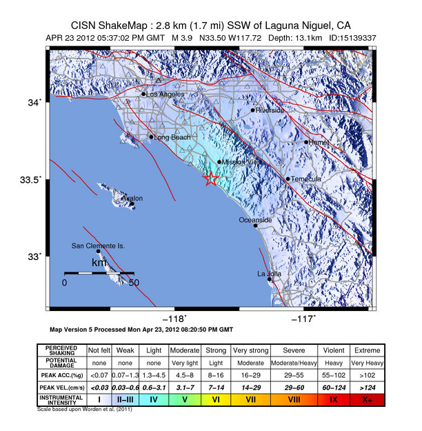
Orange County Quake Could be First on Recently Discovered Fault

LA Quake
© USGS
The earthquake may have measured only 3.9, but it still could make history in Orange County.

Monday's temblor, centered in the southern suburb of Laguna Niguel, could be the first measured on a fault discovered only 13 years ago, which runs along the coast from Newport Beach and Costa Mesa to San Juan Capistrano -- close to the San Onofre nuclear power plant.

The little-known fault - - called the San Joaquin Hills thrust -- is similar to the fault that triggered the deadly Northridge quake 18 years ago in the San Fernando Valley.

Unlike the famous San Andreas fault, which is visible from the ground, the fracture in the Earth's crust that makes up the San Joaquin Hills thrust fault is entirely underground. Because there is no visible break in the Earth's crust at ground level, the fault is perhaps more dangerous because it's unclear exactly where the boundaries of the fault are.

Scientists weren't aware of the blind thrust faults that triggered the 6.7 Northridge quake in 1994, nor the 6.0 Whittier Narrows quake in 1987 until after the ground began shaking.

Experts said Monday's temblor should serve as a wake-up call, particularly to Orange County residents who mistakenly believe that quakes are more an L.A. problem. Scientists believe that the San Joaquin Hills thrust fault is capable of generating a magnitude 7 quake or greater.

The U.S. Geological Survey in 2003 conducted a scenario of such a quake, and found it could trigger severe shaking all along southern Orange County, including Costa Mesa, Irvine, Lake Forest, Mission Viejo, Newport Beach, Laguna Beach, Dana Point and San Juan Capistrano.

Hourglass

Strong earthquakes in the past 10 years as much as during the entire 20th century

Russian scientists announced last week alarming observations about the strong earthquakes that shook the Earth. In the first decade of the 21st century there were almost as many earthquakes measuring above 6.0 on the Richter scale as there were during the entire 20th century. 14 such cases were registered in the 2001-2011 period compared to 17 strong tremors during the 20th century, the Super 19 Minuti weekly reads.

Astrologists believe that this might have something to do with entering the Age of Aquarius. By a terrifying coincidence it was on 11 March 2011 that the Fukushima disaster happened.

Bizarro Earth

Unexplained earthquake swarm in Canada: Is the big one coming?


Bizarro Earth

Earthquake Causes Panic in Indonesia

Indon Quake
© Heri Juanda/Associated PressIndonesians flee to higher ground in Banda Aceh after a tsunami warning earlier this month.
A powerful earthquake hit has waters off eastern Indonesia, sending panicked residents running from their homes, offices and schools.

Authorities said the quake did not have the potential to trigger a tsunami. The US Geological Survey said it had a preliminary magnitude of 6.6 and hit 50 miles (83km) off Papua province. It was centered just 18 miles beneath the ocean floor. There was some damage, but no immediate reports of injuries.

Children in the town of Manokwan, closest to the epicenter, were seen running from their schools screaming. Streets filled with those escaping shaking buildings.

Suharjono, an official with the country's meteorology and geophysics agency, said no tsunami warning had been issued and there were no reports of serious damage or injuries.

Indonesia, straddling a series of faultlines and volcanoes, is prone to seismic upheaval due to its location on the Pacific "ring of fire".

Earlier this month an 8.6-magnitude earthquake and 8.2-magnitude aftershock struck off the coast of northern Indonesia, but did not trigger a tsunami despite warnings. The Indian Ocean tsunami of 26 December 2004 killed 230,000 people, half of them in Indonesia's westernmost province of Aceh.

Bizarro Earth

USGS: Earthquake Magnitude 6.6 - Near the North Coast of Papua, Indonesia

Papua Quake_210412
© USGSEarthquake Location
Date-Time:
Saturday, April 21, 2012 at 01:16:54 UTC

Saturday, April 21, 2012 at 10:16:54 AM at epicenterTime of Earthquake in other Time Zones

Location:

1.609°S, 134.232°E

Depth:

29.8 km (18.5 miles)

Region:
NEAR THE NORTH COAST OF PAPUA, INDONESIA

Distances:

83 km (51 miles) SSE of Manokwari, Papua, Indonesia

341 km (211 miles) ESE of Sorong, Papua, Indonesia

990 km (615 miles) S of KOROR, Palau

1258 km (781 miles) NNE of DARWIN, Northern Territory, Australia

Bizarro Earth

USGS: Earthquake Magnitude 6.1 - Off The West Coast of Northern Sumatra (Magnitude Revised to 5.7)

Sumatra Quake_200412
© USGSEarthquake Location
Date-Time: 
Friday, April 20, 2012 at 23:14:32 UTC

Saturday, April 21, 2012 at 05:14:32 AM at epicenterTime of Earthquake in other Time Zones

Location:

2.218°N, 93.395°E

Depth:

34.3 km (21.3 miles)

Region:
OFF THE WEST COAST OF NORTHERN SUMATRA

Distances:

427 km (265 miles) SSW of Banda Aceh, Sumatra, Indonesia

530 km (329 miles) SW of Lhokseumawe, Sumatra, Indonesia

929 km (577 miles) W of KUALA LUMPUR, Malaysia

1759 km (1092 miles) WNW of JAKARTA, Java, Indonesia

Attention

Humans Behind Strongest Oklahoma Quake Ever Recorded, Research Suggests

Oklahoma Quake
© USGSMap of shaking intensity from the magnitude 5.6 earthquake that hit Oklahoma on Nov. 5, 2011.
San Diego - On the night of Nov. 5, 2011, as midnight approached, a magnitude-5.6 earthquake rocked central Oklahoma, the state's most powerful quake ever recorded. The shaking injured two people, destroyed 14 homes, and bent a local stretch of highway.

Research presented here at the annual meeting of the Seismological Society of America today (April 18) suggests the quake could be related to an industrial practice of injecting fluids deep into the Earth.

"This is part of a growing number of cases of earthquakes caused by fluid injection - and if it was found to be linked, this would be the largest," said Steve Horton, a research scientist at the University of Memphis's Center for Earthquake Research and Information.

There are three wells within 3 miles (5 kilometers) of the main shock location that are actively injecting fluids nearly a mile (1.3 km) down into the subsurface, Horton told OurAmazingPlanet.

"They are not doing fracking," Horton emphasized. Fracking, or hydraulic fracturing, a practice used to extract natural gas from deep rocks, has been much in the national consciousness lately; some have tried to link the practice to earthquakes, though no such evidence has surfaced, said scientists gathered at the SSA.

"We simply do not see that there is a connection between hydrofracking and earthquakes that are of any concern to society," William Ellsworth, a seismologist with the U.S. Geological Survey said during a media briefing.