Earth ChangesS


Snowflake Cold

UK: Worst winter for decades: Record-breaking snow predicted for November

Britain is braced for the "worst winter in decades" with the first major snowfall expected in weeks.

Image
© GETTYSnow last year caused havoc on Britain's roads
Forecasters last night warned the entire country is set for a horror freeze which will bring brutal winds and fierce blizzards.

Temperatures have already started to plunge as a swathe of cold air from the Arctic has swept across the UK in the past few days.

The first long-range forecasts warn of "recordbreaking snowfall" next month.

Heavy wintry showers are expected to cause widespread chaos with below-average temperatures possibly lingering until February.

Long-range forecasters blamed the position of a fast-flowing band of air known as the jet stream near to Britain and high pressure for the extreme conditions. Jonathan Powell, forecaster for Vantage Weather Services, said: 'We are looking at a potentially paralysing winter, the worst for decades, which could at times grind the nation to a halt.

Snowflake Cold

Germany: "Most severe winter start in 200 Years!"

Salt mine
© wikipedia.org
Last Thursday evening and yesterday winter made its debut in Southern Germany and Austria - and how! Read more here.

German RTL television last night here (starting at 4:30) called it the "most severe start of winter in 200 years!", saying many meteorologists were caught by surprise. Up to half a meter of snow fell at some locations.

Gone are the mild winters of the sort Europe seen in the 1990s and early 2000s. Indeed for central Europe the last 5 consecutive winters have all been colder than normal - a record!

These days are blockbuster times for German road salt manufacturers. In Europe municipalities have learned their lesson: ignore foolish predictions of warm winters, order huge quantities of salt, and do it early!

Candle

Alaska's Veniaminof Volcano erupts- sends traces of ash over 2 Alaskan communities

Veniaminof volcano
© Unknown
A volcano on the Alaska Peninsula has again become active during a months-long eruption, with a trace of ash falling on communities up to 35 miles away. The Alaska Volcano Observatory says in a release that Veniaminof Volcano resumed its 2013 eruption on Saturday after being quiet for about a month. It's been marked by lava flows, fountaining and intermittent but small ash, steam and gas plumes. The plumes usually only travel a few miles from the volcano, but the communities of Chignik Lake and Chignik Lagoon, about 35 miles away, reported trace ash on Friday. The observatory says ash fall from the volcano 480 miles southwest of Anchorage is not considered to be significant. The eruption started in June.

Candle

New Zealand's White Island Volcano erupts: alert level raised

White Island
© Unknown
New Zealand's geological agency GNS Science said on Saturday that it's raised the alert level for White Island after the volcano erupted. The agency said a moderate explosion eruption, lasting about a minute, happened just after 8 p.m. Friday night. GNS Science said the volcanic alert level has been raised from one to two which indicates minor activity. The aviation color code has been upgraded to orange, the second- highest alert level. GNS volcanologist Arthur Jolly said the eruption was about the same size as the previous one in August 2012, Radio New Zealand reported. Jolly said the eruption threw mostly mud, rather than ash, into the air. He said bad weather on Saturday prevented GNS volcanologists from flying over the island to observe the volcano.

Moon

USGS: Earthquake Magnitude 6.4 - 30km W of Platanos, Greece

Earthquake Greece
© USGS
Event Time
2013-10-12 13:11:52 UTC
2013-10-12 15:11:52 UTC+02:00 at epicenter
2013-10-12 15:11:52 UTC+02:00 system time

Location
35.487°N 23.261°E depth=36.2km (22.5mi)

Nearby Cities
30km (19mi) W of Platanos, Greece
68km (42mi) W of Chania, Greece
110km (68mi) W of Rethymnon, Greece
171km (106mi) W of Irakleion, Greece
279km (173mi) S of Athens, Greece

Technical Details

Cloud Precipitation

India cyclone: 12m people face mass disruption as Phailin nears east coast

More than 600,000 people evacuated amid 137mph winds as severe storm approaches Odisha and Andhra Pradesh states

Image
© UnknownThe Indian national disaster management authority (NDMA) announces cyclone Phailin is expected to reach speeds of 146 mph when it hits the country's eastern coastline on Saturday. Shashidhar Reddy, the authority's vice-chairman, says disaster response teams have been deployed in the states of Andhra Pradesh and Orissa. The NDMA has asked people living in vulnerable areas to evacuate. Phailin could be the fiercest cyclone to threaten India in 14 years
Up to 12 million people could face mass disruption from a huge storm that is expected to cause severe damage when it makes landfall in eastern India on Saturday evening.

More than 600,000 people were evacuated from India's eastern coastline on Friday as cyclone Phailin was classified as a supercyclone.

Rain and winds of at least 137mph continued to lash the east coast on Saturday while hundreds of thousands of inhabitants fled to higher ground or cyclone shelters. The Indian government issued a red alert and warned that the storm, which fills most of the bay of Bengal, could inflict serious damage when it makes landfall.

People gathered at mosques and temples in Odisha state praying that cyclone Phailin would not be as devastating as a similar storm that killed 10,000 people 14 years ago. Heavy rain pounded coastal villages in neighbouring Andhra Pradesh.

Footprints

Fracked oil spill disaster in North Dakota. Among biggest onshore spills in recent US. history - 865,200 barrels.

Oil spill in North Dakota
© APMap shows pipeline and location of spill
Over 20,600 barrels of oil fracked from the Bakken Shale has spilled from a Tesoro Logistics pipeline in Tioga, North Dakota in one of the biggest onshore oil spills in recent U.S. history.

Though the spill occurred on September 29, the U.S. National Response Center - tasked with responding to chemical and oil spills - did not make the report available until October 8 due to the ongoing government shutdown.

"The center generally makes such reports available on its website within 24 hours of their filing, but services were interrupted last week because of the U.S. government shutdown," explained Reuters.

The "Incident Summaries" portion of the National Response Center's website is currently down, and the homepage notes, "Due to [the] government shutdown, some services may not be available."

At more than 20,600 barrels - equivalent to 865,200 gallons - the spill was bigger than the April 2013 ExxonMobil Pegasus pipeline spill, which spewed 5,000-7,000 barrels of tar sands bitumen into a residential neighborhood in Mayflower, Arkansas.

Cloud Lightning

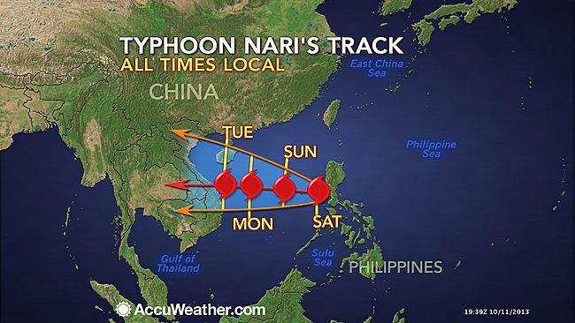
Five dead, millions without power as typhoon Nari hits Philippines

Path of cyclone Nari
© Accuweather.com
Typhoon Nari pummelled the northern Philippines early Saturday, ripping roofs off buildings, killing five people and leaving more than two million people without electricity, officials said.

Nari hit the country's east coast around midnight (1600 GMT Friday), toppling trees and pylons and dumping heavy rain as it cut a westward swathe through the farming regions of the main island of Luzon, they said.

"One of the dead was a police officer awaiting deployment for rescue duties. He was buried in a mudslide," National Disaster Risk Reduction and Management Council spokesman Rey Balido told a news conference in Manila.

Three people were crushed to death by falling trees while another person was electrocuted by a loose power line, Balido added.

The damage blacked out 37 towns and cities across central Luzon, according to a tally by the civil defence office in the region.

Road and utility crews were out clearing roads and restoring power, but it could take up to two days before electricity is restored and major highways are reopened to traffic, Nigel Lontoc, a disaster official for the region, told AFP by telephone.

A total of 2.1 million people live in the areas now without electricity, according to official population figures. Balido said four people were listed as missing, including a fisherman on the country's east coast who had been sleeping in his boat when the cyclone made landfall.

"Big waves swept the boat out to sea," he added.
Cloud Precipitation

Indian cyclone Phailin threatens 12 million, says disaster authority

Cyclone Phailin hits India
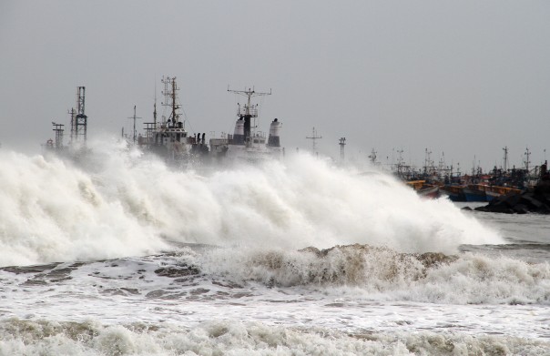
© ReutersA big wave smashes into a breakwater at a fishing harbour in Jalaripeta in the Visakhapatnam district in the southern Indian state of Andhra Pradesh.
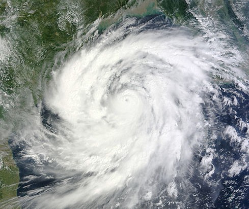
Twelve million people along India's eastern coast face mass disruption as a powerful cyclone bears down on the region in the next 24 hours, the head of the National Disaster Management Authority (NMDA) said on Friday.

Meteorologists predict Phailin could be the most catastrophic storm to hit India in 14 years, when a super cyclone pounded Odisha, leaving 10,000 people dead.

Now in the Bay of Bengal, Cyclone Phailin is forecast to reach the coast of Andhra Pradesh and Odisha states on Saturday evening, bringing gale-force winds, lashing rains, storm surges and widespread flooding.

"The affected populations ... should be about 1.2 crores (12 million)," Shashidhar Reddy, the NMDA's vice-chairman told a news conference.

Igloo

Snow falls weeks early in Munich! ...Meteorologist: "Winter strikes unusually early and severely"!

 Snow Falling
© P Gosselin
Meteorologists warned us that snow was on the way and would fall below the 500 m elevation in southern Germany and elsewhere. Moreover, they warned us that this winter could be one of the worst in 100 years for Central Europe.

No one knows if it's really going to be such a winter, but one thing is sure: it sure is starting out like one! At least in parts of Central Europe.

Wetteronline.de has put up a video (Schneefall auch in München) of snow falling in Munich this morning, October 11, 2013. Normally the first snow arrives in the Bavarian capital weeks later.