Earth ChangesS


Binoculars

US: Raccoon Blamed for 5-Hour Outage in Downtown Memphis, Tennessee

A raccoon described as acrobatic and mean-spirited knocked out power to a section of downtown Memphis that included two hospitals and the newspaper for more than five hours.

Memphis Light, Gas and Water Division president Jerry Collins told The Commercial Appeal said the raccoon climbed more than 30 feet, over barriers intended to keep animals out, and short-circuited a switch on a substation.

Overall, about 8,000 customers were without city power late Thursday and early Friday.

Cloud Lightning

Lightning Sparks New Wildfires Across Alaska

Image
© AP Photo
A barrage of lightning strikes across Interior Alaska sparked a handful of new fires on Friday, including a fast-growing blaze near Stevens Village.

The Pat Creek Fire, about 12 miles north of the Yukon River village, has exploded in size since it was detected late Friday afternoon. Fire information officer Sarah Saarloos said the blaze has "definitely grown a lot" since it was mapped at 325 acres on Saturday morning, although the size estimate hadn't been updated.

Gusty winds and dry fuels in the area contributed to the rapid growth, despite a heavy response by firefighters.

Less than 24 hours after it was reported, Saarloos said about 160 personnel were working on the fire, including 32 smokejumpers and five 20-person crews. An incident command center has been established in Stevens Village.

Cloud Lightning

India: Lightning Strikes School in Gondal, Six Kids Injured

Six students sustained injuries after lightning struck them while they were playing at a school in Gondal on Friday night.

Sources said that lightning struck Swaminarayan Gurukul School in Gondal which received 12 mm of rainfall in two hours.

"The lightning struck down six students between the age group of 10 to 15 years who were playing in the school ground at 8 pm. The students identified as Pushparajsinh Gohel, Sidhdharthsinh Jadeja, Hitendrasinh Chawda, Pratik Bhikhubhai, Hardik Vavadiya and Bhagirath Mangalubhai received burn injuries and were rushed to a hospital, where their condition is said to be stable," said an official from Rajkot district administration.

Bizarro Earth

Russian Shiveluch Volcano in Far East Spews Ash Over 3 Miles

Image
© Y. DemyanchukRussian Shiveluch volcano in Far East spews ash over 3 miles
The northernmost active volcano in Russia's Far East Kamchatka Peninsula is currently spewing plumes of ash at a height of more than 6 kilometers (3.7 miles), the regional branch of the Russian Academy of Sciences Geophysical Service said on Sunday.

The 3,283-meter (10,771-foot) Shiveluch volcano on the Kamchatka Peninsula increased its volcanic activity in May 2009 and periodically spews ash from three to eight kilometers (1.9-5 miles). Scientists have registered more than 180 local earthquakes near the volcano.

Scientists have said the volcano does not pose any significant danger to villages in the area, the nearest one, Klyuchi, only 40 kilometers (around 25 miles), except for the possibility of some ash fall.

Bad Guys

The Coming Gulf Coast Firestorm: How the BP Oil Catastrophe Could Destroy a Major U.S. City

Image
© NaturalNews
It's hurricane season in the Atlantic, and that means Mother Nature could be whipping up fierce storms and sending them charging into the Gulf Coast any day now. In a normal hurricane season, that's bad enough all by itself... remember Katrina? But now there's something even more worrisome in the recipe: There's oil in the water.

So what happens when a Katrina-class hurricane comes along and picks up a few million gallons of oil, then drops that volatile liquid on a major U.S. city like Galveston or New Orleans?

Now, before we pursue this line of thinking any further, let's dismiss the skeptics out there who think oil can't drop from the sky because oil doesn't evaporate. Actually, if you look at the history of hurricanes and storms, you'll find thousands of accounts of lots of things that don't evaporate nonetheless falling out of the sky. The phrase "raining cats and dogs" isn't entirely metaphor, you know: There are documented accounts of all sorts of things raining down from the sky: Fish, frogs, large balls of ice, and so on.

Hourglass

Arctic Birds are Contaminated with Pesticides and Heavy Metals

Image
On an isolated island high in the Arctic, biologists recently tested the toxicity of birds by testing their droppings. The conclusion? The birds' poop was loaded with environmental poisons. In these remote birds, they found high concentrations of pesticides and heavy metals including lead, mercury, aluminum and cadmium. The source of these poisons was determined to be the birds' diet of fish and shellfish and the source of the pollution of the fish and shellfish was human pollution. After these toxins were released via their excrement, they were recycled onto the earth producing toxic and contaminated areas.

The testing was done in a remote, isolated area far from industrial and agricultural pollution. In fact, there is little industry and few people anywhere close by. However, over 45 years ago atomic weapon testing was done in the area.

The media is reporting that the people who are eating the eggs of the birds are perfectly safe, but the birds' eggs weren't even tested. And if the birds' droppings contain elevated levels of these contaminants, so do the birds - and the birds' eggs. Eating mercury, lead, cadmium and aluminum is never safe and since these are in birds from isolated areas of the Arctic, it's curious to wonder what contaminants are in birds from more populated industrialized areas. Since the birds obtained these toxic poisons from the fish and shellfish they ate, it's also safe to assume that fish from less isolated areas - closer to industries and toxic agricultural runoff - are equally as polluted and likely far more so. Yet, many people are eating those fish regularly - and their poisons too.

Cloud Lightning

Unclear if Tropical Storm Alex will hit oiled Gulf

Tropical Storm Alex formed in the western Caribbean on Saturday, and forecasters said it was unclear if it would hit the massive oil spill in the Gulf of Mexico.

Forecasters at the National Hurricane Center in Miami said early Saturday that the storm has maximum sustained winds of about 45 mph. Most storm models show Alex traveling over the Yucatan Peninsula of Mexico over the weekend, hurricane forecaster Jack Bevens said.

Bevens noted it's too soon to say with certainty if the storm will pass over the oiled Gulf, though for now it's not expected to hit the spill. A storm's predicted track can quickly change as conditions shift.

Bizarro Earth

Magnitude 6.7 - Solomon Islands

Solomon Island_260610
© USGSEarthquake Location
Date-Time:
Saturday, June 26, 2010 at 05:30:20 UTC

Saturday, June 26, 2010 at 04:30:20 PM at epicenter

Time of Earthquake in other Time Zones

Location:
10.607°S, 161.429°E

Depth:
35 km (21.7 miles) set by location program

Region
SOLOMON ISLANDS

Distances:
55 km (35 miles) WSW of Kira Kira, San Cristobal, Solomon Isl.

205 km (130 miles) SE of HONIARA, Guadalcanal, Solomon Islands

220 km (135 miles) SSE of Auki, Malaita, Solomon Islands

2070 km (1280 miles) NNE of BRISBANE, Queensland, Australia

Cloud Lightning

Gale Force Winds Could Leave Gulf Oil Gushing for 2 Weeks

Image
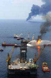
© Peter Andrew Bosch/Miami HeraldSmoke rising in the background from an in-site burning of oil caught on the water surface, as workmen on the relief well in foreground are tripping in the well bore.
Winds in excess of 45 miles per hour days away from the Deepwater Horizon gusher in the Gulf of Mexico spill could force at-sea workers to abandon their oil-collection efforts for as long as two weeks, the head of the national response effort said Friday.

That timetable would conservatively unleash another half-million barrels of oil into the sea -- twice the Exxon Valdez spill. Using upper-end federal estimates of the leak, 840,000 barrels would gush out. That's 35 million gallons.

Coast Guard Adm. Thad Allen described the cut-and-run plan in a conference call to reporters at noon Friday -- about six hours before the National Weather Service announced that a tropical depression had formed in the Caribbean.

''Realistically, over an abundance of caution,'' the admiral predicted that Deepwater Horizon's well would remain uncapped for ''14 days'' if the storm headed into the area of the Gulf where the ships are collecting oil.

Cloud Lightning

Adios El Niño, Hello La Niña?

El Nino El Nina
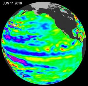
© NASA/JPL Ocean Surface Topography TeamThe latest data from the NASA/European Ocean Surface Topography Mission/Jason-2 satellite show that the tropical Pacific has switched from warm, or higher-than-normal sea surface heights (shown in red) to cold, or lower-than-normal sea surface heights (shown in blue) during the last few months.
The latest image of Pacific Ocean sea surface heights from the NASA/European Ocean Surface Topography Mission/Jason-2 oceanography satellite, dated June 11, 2010, shows that the tropical Pacific has switched from warm (red) to cold (blue) during the last few months.

The blue area in the center of the image depicts the recent appearance of cold water hugging the equator, which the satellite measures as a region of lower-than-normal sea level. Remnants of the El Niño warm water pool, shown here in red and yellow, still linger north and south of the equator in the center of the image.

The image shows sea surface height relative to normal ocean conditions. Red (warmer) areas are about 10 centimeters (4 inches) above normal. Green areas indicate near-normal conditions. Purple (cooler) areas are 14 to 18 centimeters (6 to 7 inches) below normal. Blue areas are 5 to 13 centimeters (2 to 5 inches) below normal.