Earth ChangesS


Phoenix

US: Wildfire in southeast Arizona burns nearly 50,000 acres

Image
© www.inciweb.org
An evacuation order has been lifted for residents of some communities near a southeast Arizona wildfire.

The Forest Service said Friday that fire crews will stay around Paradise and the Southwest Research Center to patrol the area for fires.

The U.S. Forest Service says west to southwest winds at 10 to 18 mph are expected with gusts of 25 to 30 mph.

Low humidity and slightly cooler temperatures are expected.

Meanwhile, the Horseshoe Two fire has risen to nearly 50,000 acres and is 40 percent contained.

Snowman

US: Late snowfall could hurt Memorial Day mountain tourism


Grand Lake - It is nearly June and Colorado's mountains still look as though we're at the beginning of March.

"This is what it looks like all winter out here," Pat Randall, a store owner in Grand Lake, said.

The snow that has kept falling in the high country has made for a different spring.

Independence Pass opened Thursday, but Mt. Evans Road is only halfway open and Trail Ridge Road is still closed because of all the late snow. Arapahoe Basin and Aspen are still open for skiers.

Bizarro Earth

The volcanic glass cloud: How tiny shards created by heat of Iceland eruption have 'rained' on Scotland

Scientists have released photographs of what they believe are volcanic glass particles from Iceland which fell on Scotland this week.

The samples were taken from a car windscreen in Aberdeen and analysed at the city's James Hutton Institute.

The images of the tiny particles were taken using a scanning electron microscope.
Image
© PASharp: One of the fragments of glass that rained on Aberdeen is shown under a microscope

Scientists said it was 'highly likely' the glass particles, which are part of the ash constituents, came from the Grimsvotn volcano which started erupting on Saturday.

Commercial glass is created by heating silica, or sand, to an extremely high temperature. Sand scorched by lava could do the same.

The largest of the particles found is 0.03mm across, with the smallest measuring just 0.002mm wide.

The institute also analysed samples given to them by the Scottish Environment Protection Agency (Sepa) taken in Lerwick, Shetland, which matched the particles taken from the car window.

Radar

NASA: Songda Becomes a Super Typhoon

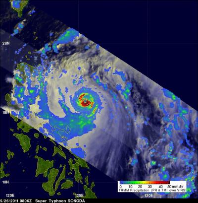
As predicted, Typhoon Songda intensified and was a super typhoon with wind speeds estimated at over 130 knots ( ~145 mph) when NASA's TRMM satellite passed directly over head on May 26, 2011 at 0806 UTC (4:06 a.m. EDT).

Songda had a circular eye
© NASA/SSAI, Hal PierceSongda had a circular eye with extremely heavy rainfall, particularly in the southeast quadrant. The red areas represent heavy rainfall (falling at about 2 inches/50 mm per hour). The yellow and green areas are moderate rainfall, falling at a rate between .78 to 1.57 inches (20 to 40 mm) per hour.

Butterfly

Strange He-She Birds Present Gender-Bending Mystery

The unusual cardinal
© Larry P. Ammann, RemoteSensingArt.comThe unusual cardinal that appeared at Larry Ammann's backyard feeder.

A strange bird showed up in Larry Ammann's backyard on Jan. 14. Clearly a cardinal, it had the bright red plumage of a male on its left side and gray, female feathers on its right.

"I had no clue how on Earth something like that could happen," said Ammann, a professor of statistics and a wildlife photographer who lives in a suburb of Dallas. "It was a learning experience."

Ammann and the biologists he consulted concluded the bird was most likely part female, part male. Creatures with this condition are called gynandromorphs. They are genetic anomalies: Some cells in their bodies carry the genetic instructions for a male, some for a female. While this gender-bending also occurs among insects, spiders and crustaceans, birds like this cardinal have raised questions about how sex identity is determined among some animals.

As the breeding season began, other cardinals became more territorial, and the bird disappeared before it could be trapped and its feathers collected for genetic testing.

Umbrella

US: Storms Will Drop Heavy Rains for 2 Days in West Michigan

Image
© Grand Rapids Press
A flood watch has been issued for much of West Michigan, with several rounds of heavy rain likely today and Thursday.

Two to four inches are possible, along with the threat of severe storms, and a tornado watch is issued through 7 p.m. today for these counties: Berrien, Branch, Cass and St. Joseph.

"A warm front moving could bring some nastier stuff later this afternoon. Heavy rain is a probability, not a possibility," said Mike Kalembkiewicz of the National Weather Service in Grand Rapids.
Image
© National Weather ServiceRainfall could accumulate to two inches or more through Thursday.

Bizarro Earth

Scientists ask Britons to help map Grimsvotn ash

Image
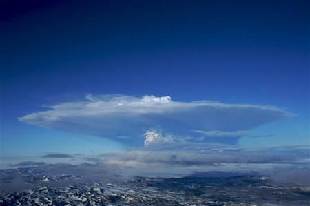
© Reuters/Olafur SigurjonssonSmoke plume rises from the eruption of the Grimsvotn volcano, under the Vatnajokull glacier in southern Iceland May 21, 2011
Geoscientists at the British Geological Survey (BGS.L) group asked members of the public for help on Wednesday with observations of volcanic ash from the eruption of the Grimsvotn volcano in Iceland.

BGS scientist Aoife O'Mongain said the group has developed a simple online questionnaire with questions like: 'Have you seen ash/dust on your car windscreen?' and 'Have you smelt sulphur (rotten eggs)?' which should help map the ash's reach.

"There is a short time window for ash observations for this eruption so any observations are welcomed, especially within the next 24 hours," O'Mongain said in a statement.

A map showing real-time survey results can be viewed by following the link at www.bgs.ac.uk.

Bizarro Earth

Iceland: Volcano grounds 500 flights but plume shrinking

Image
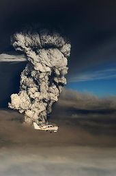
© ReutersA plane flies past smoke plume from the eruption of the Grimsvotn volcano, under the Vatnajokull glacier in southeast Iceland.
Reykjavik - Activity at Iceland's erupting volcano has slowed significantly and its ash plume, which has dropped to a fraction of its 20 kilometre peak, could disappear by the weekend, experts said on Tuesday.

The plume of ash from Grimsvotn, located in the southeast of Iceland at the heart of its largest glacier, Vatnajoekull, had fallen to two kilometers on Tuesday evening, according to an Icelandic crisis management official.

The column "is decreasing now and the height of the plume is around two kilometers so it's dramatically decreased," Thorir Hrafnsson, a spokesman for Iceland's crisis management agency, told AFP.

"If it behaves like earlier eruptions, hopefully it will be over by the weekend," he said, while stressing "it's very hard to guess."

At an altitude of just two kilometres, the plume "will not be dangerous for air traffic," Hrafnsson said, acknowledging that ash still in the air from the initial blast could continue to cause problems.
Radar

Best of the Web: Iceland volcano: BA test flight found nothing - CAA Proves Incompetent

Willie Walsh, chief executive of International Airlines Group, said BA had conducted a 45-minute test flight at different altitudes over the north of England, Newcastle, Glasgow and Edinburgh, where the ash cloud was meant to be at its densest, on Tuesday.

Disclosing the results of tests carried out on the aircraft after the test run, he told the BBC's Today program: "The simple answer is we found nothing."

Pledging to make a case to the Civil Aviation Authority that the test proves it is safe to fly through the cloud, he added: "I think we need to understand the levels of concentration that we are talking about...the levels are absolutely tiny."

His remarks came after Michael O'Leary, the outspoken head of Ryanair, described the ash cloud as "mythical" after the airline operated a similar test flight across air space with the highest ash densities.

Rounding on the Civil Aviation Authority, he said its officials should "take their finger out of their incompetent bureaucratic backsides and allow the aircraft back into the skies over Scotland".


Attention

US: Joplin Storm Contained a Rare Multivortex Tornado

Image
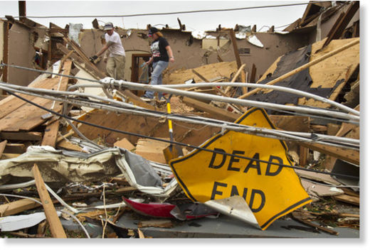
© David EulittShawn and Joella Zaccarello of Joplin pitched in Tuesday to help sort through the damage of their uncle’s home, which was destroyed by Sunday evening’s tornado that swept through the city’s central section.

The death toll from Sunday's tornado has risen to 122, making it the eighth-deadliest tornado in U.S. history, the National Weather Service said.

The Joplin twister was upgraded to EF-5, the strongest category on the Enhanced Fujita Scale, with winds exceeding 200 mph. The storm was apparently a "multivortex" tornado, with two or more small and intense centers of rotation orbiting the larger funnel, a rare occurrence.

It's the country's deadliest storm since 1950.

The number of those still missing isn't known because many have left Joplin to stay with relatives and friends. Rescue workers on Tuesday were able to save two more people from the wreckage, bringing the total to nine, even as they braced for more storms Tuesday night.

Those storms brought their own misery: Several tornadoes struck Oklahoma City and its suburbs during rush hour, killing at least five people and injuring at least 60 others, including three children who were in critical condition, authorities said.