Earth ChangesS


Bizarro Earth

Obama Officials Pushed to Underestimate Gulf Oil Spill

Deepwater Horizon on fire
© n/a
Amid the worst accidental release of crude oil in human history, the Obama administration sought to undermine its own scientists' estimates of just how much oil was gushing into the Gulf of Mexico, a newly disclosed email reveals.

Obtained by a Freedom of Information Act (FOIA) request filed by the advocacy group Public Employees for Environmental Responsibility (PEER), the message shows how the White House, the National Incident Command (NIC) and Department of the Interior (DOI) recommended scientists with the U.S. Geologic Survey (USGS) lowball their estimates in public statements.

The agency was able to determine that at least 25,000 barrels of oil were gushing out of the damaged BP well in the gulf - an estimate they said was on the low end of the spectrum. But when those figures were reported by members of the press, they were stated dramatically lower, sparking complaints from scientists who felt their findings were being misrepresented.

The email's author, Dr. Marcia McNutt, replied to the team by explaining that the White House had suggested she "simplify" the USGS estimate by claiming there was around 12,000 to 19,000 barrels per day gushing from the well, or "as high as 25,000 barrels per day."

Info

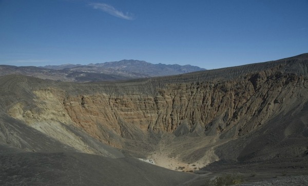
Explosive Volcano May Lurk Beneath Death Valley

Death Valley Crater
© Brent Goehring/Lamont-Doherty Earth ObservatoryDeath Valley's massive Ubehebe Crater. New evidence suggests this sleeping giant could awaken sooner than once thought.
California's Death Valley, already one of the hottest places on Earth, may have the potential to get a whole lot hotter - and live up to its name in a surprising (and possibly scary) new way, according to new research.

Scientists have long known that the craters that pepper this dry landscape were formed by long-ago volcanic eruptions, triggered when hot magma ascending from inside the planet hit pockets of water.

Some researchers now think the area erupted far more recently than thought, meaning the parched swath of central California, home to desolate salt flats and scalding temperatures, could be primed for a follow-up.

Dates for the geological catastrophe are fuzzy, but researchers used to think that Death Valley's largest crater, a half-mile (0.8 kilometer) wide gash in the Earth nearly 800 feet (240 meters) deep, formed in 4000 BC.

Yet new evidence uncovered by a team of scientists at Columbia University's Lamont-Doherty Earth Observatory suggests the dramatic crater, called Ubehebe, last erupted only 800 hundred years ago.

Bizarro Earth

Offshore Bio-Bio, Chile - Earthquake Magnitude 6.2

Bio-Bio Quake_230112
© USGSEarthquake Location.
Date-Time
Monday, January 23, 2012 at 16:04:54 UTC

Monday, January 23, 2012 at 01:04:54 PM at epicenter

Time of Earthquake in other Time Zones

Location
36.415°S, 73.015°W

Depth
29.7 km (18.5 miles)

Region
OFFSHORE BIO-BIO, CHILE

Distances
50 km (31 miles) N of Concepcion, Bio-Bio, Chile

80 km (49 miles) SW of Cauquenes, Maule, Chile

90 km (55 miles) WNW of Chillan, Bio-Bio, Chile

393 km (244 miles) SSW of SANTIAGO, Region Metropolitana, Chile

Better Earth

Magnitude-5.0 shakes Big Island in Hawaii

Hilo, Hawaii - A magnitude-5.0 earthquake and several small aftershocks shook Hawaii's Big Island on Sunday, but there were no reports of injury or damage.

The quake struck near Holei Pali beneath the south flank of Kilauea volcano in Hawaii Volcanoes National Park at 4:36 p.m. (6:36 p.m. PST) at a depth of five miles, according to a report from the U.S. Geological Survey. The epicenter was about 25 miles south of Hilo and 220 miles southeast of Honolulu.

There was no tsunami threat.

About 20 small aftershocks came in the hours that followed, the largest a magnitude-3.1 about 10 minutes after the original quake.

The temblor was widely felt in Hilo and throughout the island, with more than 500 people reporting that they felt light-to-moderate shaking, according to the USGS website.

Joe Lopez, 70, said he felt a "pretty good jolt" at his home in Hilo.

Lopez told the Honolulu Star-Advertiser the quake sent books and other items tumbling to the floor.

There have been no reports of injury or damage, said Michael Yoshimura of Hawaii State Civil Defense.

Yoshimura said the agency opened its Hilo Emergency Operating Center immediately after the quake, but closed it down when no calls came in after 45 minutes.

The quake struck near the so-called Holei Pali area of Kilauea's south flank has had 16 earthquakes of magnitude-4.5 or greater in the past 50 years - eight of them since 1983, Hawaiian Volcano Observatory spokeswoman Janet Babb said in a statement Sunday night.

The observatory has not detected any significant changes in activity at the summits or rift zones of the Kilauea or Mauna Loa volcanoes, Babb said.

Cloud Lightning

US: 2 Dead as Storms Pound South, Midwest

Image
© Unknown
Clay, Alabama - Two people were killed in the Birmingham, Ala., area as storms pounded the South and Midwest, prompting tornado warnings in a handful of states early Monday.

At least one of the areas affected by the storms, which were part of a system that stretched from the Great Lakes down to the Gulf of Mexico, was also hit by a line of killer storms that slammed the Southeast last April.

Jefferson County sheriff's spokesman Randy Christian said a 16-year-old girl was killed in Clay and an 82-year-old man died in the community of Oak Grove.

The storm produced a possible tornado that moved across northern Jefferson County around 3:30 a.m., causing damage in Oak Grove, Graysville, Fultondale, Center Point, Clay and Trussville, Christian said. He said several homes were destroyed and numerous injuries were reported.

"Some roads are impassable, there are a number of county roads where you have either debris down, trees down, damage from homes," said Yasamie Richardson, a spokeswoman for the Alabama Emergency Management Agency. Jefferson County experienced "significant damage," she said.
Evil Rays

Australia: Stingray bites boy at theme park

Stingray
© UnknownStingrays can fly... almost
A six-year-old boy has been bitten on the finger by a stingray at a theme park on Queensland's Gold Coast.

It happened at a Sea World exhibit yesterday morning.

The boy's wound was treated by a nurse at the theme park and he was taken to hospital as a precaution.

Sea World says it is the first time such an injury has occurred since the Ray Reef attraction opened in 2009.

Bizarro Earth

New Zealand: More Whales Stranded at Farewell Spit

Stranded Whales
© AAPPilot whales are stranded in the South Island for the third time in two months.
A group of whales has been stranded around Farewell Spit, near the top of the South Island, for the third time in two months.

About 90 pilot whales were seen milling close to the shore around noon on Monday and have since grounded on a receding tide, Project Jonah chief executive Kimberly Muncaster says.

Ms Muncaster says volunteers will care for the whales until nightfall, when the fast incoming tide will be a danger to the people.

"There's a small chance the whales may refloat on tonight's high tide at 11pm, but we will be back at first light to assess the situation and assist DOC (the Department of Conservation) in their rescue response," she said on Monday.

"Hopefully we'll be able to keep as many whales as possible alive until nightfall."

Nuke

The Radioactive Waste Crisis

nuclear waste barrels
© Taipei Times
A Mountain Almost 70 Years High

Before the month of January is out, the US Department of Energy's Blue Ribbon Commission on America's Nuclear Future will unveil the result of its two year-long investigation into what to do with the accumulated radioactive waste at the country's nuclear power plants. By this year's end, that waste will constitute a mountain 70 years high, with the first cupful generated on December 2, 1942 at the Fermi lab not far from Chicago when scientists first created a self-sustaining nuclear chain reaction.

There remains no viable solution for either the management or certainly the "disposal" of nuclear waste. Yet, the one recommendation that will not be contained in the DOE report is to stop making any more of it. While a child would never be allowed to continue piling up toys in his or her room indefinitely, failing to tidy up the mess, the nuclear industry continues to be permitted to manufacture some of the world's most toxic detritus without a cleanup plan.

A sneak peak last July at the Commission's draft report confirms that no new miracles are to be unveiled this month. Its preferred "solution" appears to be "centralized interim" storage, an allegedly temporary but potentially permanent parking lot dumpsite for highly radioactive waste that, based on past practices, will likely be targeted for an Indian reservation or a poor community of color.

Cloud Lightning

Tornadoes Possible in Southern U.S. as Snow Threatens

Severe storms were expected to spread across several southeastern U.S. states on Sunday into Monday with tornadoes, highwinds and large hail possible, weather forecasters said.

A second stormfront expected to hit California late Sunday night will bring significant snowfall to the mountain regions, according to the National Weather Service, before rolling into the southern United States later in the week.

The potential for severe storms stretched from the Gulf of Mexico in Mississippi to southern Indiana and Ohio, according to AccuWeather.com meteorologist Bill Deger.

Bizarro Earth

South Sandwich Islands Region - Earthquake Magnitude 6.0

Sandwich Isles Quake_220112
© USGS
Date-Time
Sunday, January 22, 2012 at 05:53:41 UTC

Sunday, January 22, 2012 at 03:53:41 AM at epicenter

Time of Earthquake in other Time Zones

Location
56.670°S, 25.018°W

Depth
9.8 km (6.1 miles)

Region
SOUTH SANDWICH ISLANDS REGION

Distances
138 km (85 miles) E of Visokoi Island, South Sandwich Islands

281 km (174 miles) NNE of Bristol Island, South Sandwich Islands

2195 km (1363 miles) ESE of STANLEY, Falkland Islands

3532 km (2194 miles) SE of BUENOS AIRES, D.F., Argentina