Earth ChangesS


Bizarro Earth

Earthquakes strike Ireland and southwest of Santorini volcano in Crete

People in north Donegal were left shaken, but hopefully not too stirred, last night when an earthquake tremor hit the region. Tom Blake, a geophysicist at the Dublin School for Advanced Studies confirmed that a 2.2 magnitude tremor struck north Donegal at 1.04 am. The tremor was recorded at a seismic monitoring station in Inishowen.
Image
© Unknown
The station was set up and is operated in association with LYIT and North West Electronics. The tremor was also recorded at St. Columba's National School and St. Egney's Desertegney, where equipment has been in place for some time. According to the Donegal Weather Channel, hundreds of people felt the tremor right across north Donegal, areas affected included Letterkenny, Buncrana, Kilmacrennan, Raphoe, Ramelton, Carrigard and Downings.

Bizarro Earth

Massive landslide in Papua New Guinea claims 40 lives- dozens still missing

Dozens of people are feared to have been buried in a massive landslide in the Southern Highlands of Papua New Guinea. According to VOA, at least 40 bodies have been pulled from the debris and as many as 20 others are feared missing.


The landslide struck at 7am AEDT yesterday near the Nogoli base for a ExxonMobil-led liquefied natural gas plant site, northwest of Port Moresby. One local said three villages had been covered while another report said only a handful of homes were lost. Radio Australia reported dozens of people were feared buried, quoting a Tari resident as saying about 40 people were missing.

Bizarro Earth

US: Alaska - Earthquake Magnitude 5.1 - Fox Islands, Aleutian Islands

Image
© USGS
Date-Time:
Wednesday, January 25, 2012 at 00:46:00 UTC

Tuesday, January 24, 2012 at 03:46:00 PM at epicenter

Time of Earthquake in other Time Zones

Location:
52.809°N, 167.095°W

Depth:
39.4 km (24.5 miles)

Region:
FOX ISLANDS, ALEUTIAN ISLANDS, ALASKA

Distances:
119 km (73 miles) E of Nikolski, Alaska

127 km (78 miles) SSW of Dutch Harbor, Alaska

1395 km (866 miles) SW of Anchorage, Alaska

2121 km (1317 miles) W of WHITEHORSE, Yukon Territory, Canada

Bizarro Earth

Earthquakes strike regions of US Mt. St. Helens and northern Italy

Image
© USGS
A magnitude 3.4 earthquake occurred at 2:51 a.m. Wednesday about 10 miles north of Mount St. Helens. The Pacific Northwest Seismic Network reports mild shaking was felt in Longview, Castle Rock and Morton. The University of Washington reports the quake was followed by a half-dozen small aftershocks in the next hour. Small quakes are common in the area around the volcano in southwest Washington.

Image
© Unknown
A 5.1 magnitude earthquake struck the northern region of Italy at a depth of 10.2 km or 6.3 miles below the surface. The epicenter of the earthquake was about 13 km from Parma, Italy and about 368 km from Rome. The earthquake was preceded by a much shallower 4.0 foreshock some 47 km away. Italy has seen a growing amount of seismic unrest along the northern mountainous region of the country. The Alpide Belt which runs along the southern region of Europe and Asia continues to show signs of stress. In the meantime, we continue to monitor the stresses erupting along the planet's lower southern hemisphere. A 5.1 magnitude earthquake was reported west of New Zealand's South Island.

Bizarro Earth

Australia: Thousands evacuated in NS Wales as torrential rains soak Queensland

About 4,200 people have been evacuated from their homes on the New South Wales far north coast, after the same weather system that drenched Queensland moved south.

Ten flood warnings are in place for rivers in the state's north-east, where up to 550 millimetres of rain has fallen in some areas over three days.


People have been evacuated from parts of Chinderah, Fingal Head, South Murwillumbah, Condong and Tumbulgum.

Bizarro Earth

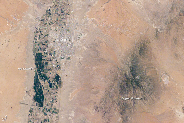
US: GPS Uncovers Possible Southwest Quake Risk

The U.S. Southwest isn't particularly known for its seismic activity, but the Rio Grande Rift, a series of faults and basins that runs from central Colorado south through New Mexico, is alive and stretching, new research shows.

Scientists had suspected the rift might be dead, but measurements of its movement varied widely and were riddled with uncertainties. Now, thanks to state-of-the-art GPS technology, geophysicists have found the rift is indeed extending - just very slowly.

And of course, anytime a large chunk of the Earth's crust moves, the issue of earthquakes arises.
Rio Grande Rift
© NASAThe city of Las Cruces is located within the Rio Grande Rift, a large geological feature that extends from Colorado southwards into Mexico. The Rio Grande Rift is marked by a series of depressions (known as graben) punctuated with uplifted mountains. The grabens form when blocks of the Earth’s crust sink as geologic forces pull the crust apart along fault lines. Sinking in one place is often accompanied by uplift along boundaries of the grabens—the striking Organ Mountains to the east of Las Cruces are one such uplifted fault block.

Bizarro Earth

Apocalyptic Sounds from Around the Globe!!! 2011 - 2012


Igloo

Arctic Ocean Freshwater Bulge Detected


UK scientists have detected a huge dome of fresh water that is developing in the western Arctic Ocean.

The bulge is some 8,000 cubic km in size and has risen by about 15cm since 2002.

The team thinks it may be the result of strong winds whipping up a great clockwise current in the northern polar region called the Beaufort Gyre.

This would force the water together, raising sea surface height, the group tells the journal Nature Geoscience.

"In the western Arctic, the Beaufort Gyre is driven by a permanent anti-cyclonic wind circulation. It drives the water, forcing it to pile up in the centre of gyre, and this domes the sea surface," explained lead author Dr Katharine Giles from the Centre for Polar Observation and Modelling (CPOM) at University College London.
Cloud Lightning

Australia: 5,000 fish found dead in Perth's Swan River

Swan River
© ABC NewsLow oxygen levels have killed 5,000 fish in the Swan River
Low oxygen levels and hot weather are believed to have killed thousands of fish in Perth's Swan River.

About 5,000 dead fish were discovered between the Middle Swan Bridge and the Ellen Brook in the upper reaches of the river.

Swan River Trust spokesman Mark Cugley says recent rain and hot weather have decreased oxygen levels in the waterway and that particular area is outside the reach of the river's oxygenation plants.

Comment: In other words, it rained a lot in Perth.


Bizarro Earth

Fiji Islands - Earthquake Magnitude 6.3

Fiji Quake_240112
© USGSEarthquake Location
Date-Time
Tuesday, January 24, 2012 at 00:52:06 UTC

Tuesday, January 24, 2012 at 12:52:06 PM at epicenter

Time of Earthquake in other Time Zones

Location
24.959°S, 178.611°E

Depth
582.8 km (362.2 miles)

Region
SOUTH OF THE FIJI ISLANDS

Distances
543 km (337 miles) SE of Ceva-i-Ra, Fiji

551 km (342 miles) SSW of Ndoi Island, Fiji

756 km (469 miles) S of SUVA, Viti Levu, Fiji

1370 km (851 miles) NNE of Auckland, New Zealand