Earth ChangesS


Nuke

Traces of Mystery Radiation Detected Across Europe

Radiation Sign
© Life's Little Mysteries

Trace amounts of the radioactive material iodine-131 have been detected across Europe over the past two weeks, according to nuclear officials there. The source of this radiation-spewing material is unknown.

Iodine-131 is a by-product of the type of nuclear fission reactions that occur in reactors and nuclear weapons; it emits radiation that can cause cancer when absorbed in high enough doses. The International Atomic Energy Agency (IAEA) said the levels of iodine-131 that have been detected in several locations across Europe are abnormally high, but not high enough to pose a public health risk, Reuters reported today (Nov. 11).

Austria's Environment Ministry said the small levels of radioactive iodine it detected would expose the population to a radiation dose equal to just one-40,000th of the dose received in a transatlantic flight.

Bizarro Earth

Australia: Whales Stranded on Tasmanian Beach

Stranded Whales
© Audience Submitted22 sperm whales are stranded on Ocean Beach on Tasmania's west coast.

There has been a mass stranding of 20 sperm whales on Tasmania's west coast, with only four whales stuck in shallow water believed to still be alive.

The pod was discovered on Ocean Beach near Strahan early Saturday morning, but authorities say conditions in the water are too dangerous for rescuers to intervene.

Nearby, rescuers were making progress in freeing another eight sperm whales stranded on a sand bar in Macquarie Harbour, about four kilometres south of the beach.

Chris Arthur from the Parks and Wildlife Service says four of them were swimming freely, with a fifth joining them later in the afternoon.

Authorities are urging people to stay clear of the channel between Hells Gate and Table Head.

Arrow Up

El Hierro Underwater Volcano's Eruption in Photos

Image
A brand new Canary island is emerging from the sea as an underwater volcano bubbles to the surface.

Magma off the Canary Island of El Hierro has been spewing 20 metres high as the sea boils with a smell of sulphur.

As it grows and gets closer to the surface, more and more debris such as stones start to shoot out of the volcano which, until now, has only shown its explosive power below the surface.

It is now just 70 metres from the surface and islanders are already trying to come up with a name for the new island. It is quite close to El Hierro and if it continues to erupt it could eventually meet up with the mainland.

Megaphone

Canada 'could expect' massive earthquake at any time: geophysicist

Earthquake Bowman, Que
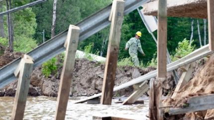
© Adrian Wyld / The Canadian PressA Hydro Quebec worker navigates a causeway where a section of road collapsed following an earthquake in Bowman, Que., Wednesday, June 23, 2010. (Adrian Wyld / THE CANADIAN PRESS)
Canada could expect a major earthquake at any time and a top geophysicist says it should prepare itself if it is to avoid the kind of disasters that befell Japan, Italy and China in recent years.

John Cassidy, head of earthquake seismology at the Geological Survey of Canada, says large earthquakes have hit parts of Canada numerous times - and will again.

"Certainly we could expect an earthquake at any time and should be prepared for a large earthquake at any time in Canada," Cassidy said in an interview prior to delivering a lecture at Carleton University.

"We've seen many over the years, going back in time."

He says the most vulnerable region is the West Coast, which has been hit with giant, magnitude-9.0 quakes 13 times in the last 6,000 years, the last of them 311 years ago.

Bizarro Earth

US: Earthquake Magnitude 4.2 Western Montana

Image
© USGS
Date-Time:
Friday, November 11, 2011 at 17:51:53 UTC

Friday, November 11, 2011 at 10:51:53 AM at epicenter

Time of Earthquake in other Time Zones

Location:
46.618°N, 113.557°W

Depth:
12.1 km (7.5 miles)

Region:
WESTERN MONTANA

Distances:
21 km (13 miles) SE (145°) from Clinton, MT

32 km (20 miles) W (260°) from Drummond, MT

37 km (23 miles) NNW (328°) from Philipsburg, MT

314 km (195 miles) ESE (111°) from Spokane, WA

666 km (414 miles) N (349°) from Salt Lake City, UT

Bizarro Earth

New Caledonia: Earthquake Magnitude 5.2 Offshore

Image
© USGS
Date-Time:
Friday, November 11, 2011 at 19:00:47 UTC

Saturday, November 12, 2011 at 06:00:47 AM at epicenter

Time of Earthquake in other Time Zones

Location:
22.750°S, 168.268°E

Depth:
130.7 km (81.2 miles)

Region:
NEW CALEDONIA

Distances:
138 km (85 miles) SSE of Tadine, Loyalty Islands, New Caledonia

194 km (120 miles) ESE of NOUMEA, New Caledonia

369 km (229 miles) SSW of Isangel, Tanna, Vanuatu

1624 km (1009 miles) ENE of BRISBANE, Queensland, Australia

Bizarro Earth

Hurricane Hunters Fly into Tropical Storm Sean

Image
© U.S. Air Force, Staff Sgt. Valerie SmockThick clouds surround the Hurricane Hunters' WC-130J aircraft as it heads into Tropical Storm Lee in early September 2011
Storm-chasing aircraft headed out over the Atlantic Ocean and into the swirling clouds of Tropical Storm Sean this week, taking measurements that allowed forecasters to confirm their suspicions about the season's 18th named storm.

"It's textbook. A textbook storm," said Dennis Feltgen, spokesman for the National Hurricane Center in Miami, Fla.

The weakening storm, packing winds of about 50 mph (80 kph), is heading northeast, away from the United States, and looks like it will weaken significantly in the coming days.

However, Feltgen said, forecasters didn't know that for sure until they got word back from the plane that was flying through Sean's thunderstorms and high winds.

"If the storm has any possible threat to land at all, a hurricane-hunter aircraft is going to go into it - that's a given," Feltgen told OurAmazingPlanet, "and this storm is threatening Bermuda."
Bizarro Earth

US: Colored Clouds Over Nebraska

Auroras in Nebraska are rare, but who needs auroras when you've got iridescence? University of Nebraska freshman Evan Ludes took this picture of cloud-colors over Omaha on the morning of Nov. 10th:

Colored Skies
© Evan LudesImage Taken: Nov. 10, 2011
Location: Omaha, Nebraska
"I walked out of class this morning and was greeted by one of the best iridescence displays I've ever seen!" says Ludes. "The colors formed on the leading edge of a long stretch of cirrocumulus clouds."

Iridescent colors appear when sunlight shines through water droplets in the edges of clouds. The mechanism is diffraction. The colors are at their brightest and most distinct when the droplets are small and uniformly-sized.

"I'm no optics expert," says Ludes, "but I'm guessing the colors were particularly vivid since these clouds were newly formed and therefore likely had water droplets of similar shape and size. It was incredible how distinct the bands of colors were even when zoomed in at 300mm!"

Bizarro Earth

US: Oklahoma Struck By Biggest November Tornado on Record

Tornado
© Steve Grabman/NWSThe biggest November tornado in Oklahoma's history.
Oklahoma earlier this week became witness to the state's biggest November tornado since reliable records began in 1950.

The tornado touched down in Tipton, Okla., earlier this week and was upgraded yesterday (Nov. 10) to an EF-4, the second-highest rating on the Enhanced Fujita Tornado damage scale, after a storm survey team analyzed its destruction.

"We've had some biggies come through from time to time, but never an EF-4 in November," said Gary McManus, of the Oklahoma Climatological Survey, which operates the Mesonet weather data collection towers across the state. One of the 30-foot-tall (10 meters) weather collection towers was toppled by the EF-4 tornado.

The massive fall twister demolished an Oklahoma State University extension office, according to the storm survey report from the National Weather Service (NWS) in Norman, Okla. The tornado had estimated winds between 166 and 200 mph (267 kph to 322 kph), significantly stronger than its EF-2 preliminary rating.

Bizarro Earth

First Picture Emerges of Infant Underwater Volcano

New Volcano
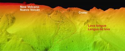
© IEO/MICINNThis image was recently taken and shows the new volcano and its lava tongue that descends in the path of the old underwater valley.
It is rare that the birth of an island can be watched by humans in real-time, but that could be what is happening in Spain's Canary Islands.

Residents of La Restinga on the island of El Hierro were recently evacuated after weeks of earthquakes and the growing threat of an erupting underwater volcano that is making its presence known on the surface with an expanding, bubbling patch of dark debris.

The seismic activity off the coast alerted scientists to the fact that something interesting was happening under the sea. To get a better look, a team of researchers from the Spanish Institute of Oceanography (IEO) went out on the water and were able to get a high-resolution picture of the volcano in less than two weeks.

The volcanic cone stretches nearly 330 feet (100 meters) above the seafloor, and is 2,300 feet (700 m) wide at its base. Lava is currently oozing out of a crater in the center that is about 390 feet (120 m) wide.