Earth ChangesS


Bizarro Earth

USGS Reports Record Number Of Strong Earthquakes In 2011

Image
© UnknownSeismic chart of the 11 March 2011 Japan earthquake
The number of dangerous earthquakes recorded worldwide so far in 2011 has reached record new levels, according to research conducted by iWeather Online (IWO).

By analysing data from the US Geological Survey (USGS), IWO was able to determine that earthquake activity (6.0-9.9 magnitude) during the period 01 January to 12 October 2011 reached its highest level in 20 years. The 2011 data was compared with data for the corresponding period in each of the 19 previous years since 1992.

A total of 177 earthquakes in the range 6.0 to 10 magnitude on the Richter Scale have been recorded so far in 2011, compared to 149 for the same period in 2010 and 119 in 2009.

Recent earthquakes exceeding 6 magnitude on the Richter Scale have occurred in Tonga (08 Oct), northern Argentina (06 Oct), India/Nepal (18 Oct), Cuba (15 Sept), northern Sumatra (05 Sept), Vanuatu (03 Sept), Alaska (02 Sept), and East Timor (30 Aug).

Interestingly, the total number of earthquakes (magnitude 0-9.9 magnitude) recorded in 2011 is dramatically lower than the previous four years since 2007.
Cloud Lightning

US: Severe weather leads to power outages, wrecks in North Texas

Thousands in North Texas woke up this morning to find their homes without power after severe weather blew through the area overnight.

As of 6:30 a.m., there were about 5,000 outages in the Dallas-Fort Worth area, according to Cristi Ramon, a spokeswoman for Oncor. While Occupy Dallas protesters donned ponchos and took shelter in their tents as rain fell down on Pioneer Plaza, drivers across North Texas reported accidents and high water.


Bizarro Earth

Subsea Volcanic Eruption Underway Near El Hierro (The Canary Islands)

A submarine volcanic eruption is taking place approximately 5 kilometres off the southern coast of El Hierro, the smallest of The Canary Islands.

The Mayor of La Frontera (El Hierro), David Cabrera, confirmed in an interview on Radio iron Garoé that 'underwater eruption' is taking place about 900 metres beneath the sea surface five kilometres south of La Restinga. The eruption has been ongoing for four hours, the Mayor said.

Spanish newspaper laopionion.es quoted the Minister of emergencies of the Cabildo of El Hierro, Maria of Carmen Morales, as saying the eruption is taking place because 'the seismic movement of 4.3 occurred on Saturday afternoon caused a fissure, from where the energy is been released'. Scientists remain unclear if the emissions are gas or lava.

Image
© MODISEl Hierro, The Canary Islands, from space in this MODIS satellite image on Oct. 7 2011

Bizarro Earth

Volcanic Red Alert Issued As Residents Are Evacuated From El Hierro Town

Spain's Instituto Geográfico Nacional (IGN) confirmed on Tuesday that an underwater eruption has occurred five kilometres off the southern coastline of El Hierro, the smallest of the Canary Island. The eruption is Spain's first since the eruption in 1971 of the Teneguía volcano on the island of La Palma (Canary Islands).

The IGN says all three of its seismic stations on El Hierro in the Canary Islands have registered a volcanic tremor of low frequency in the south of the island at La Restinga, the southern-most village in the Canaries. The estimated 537 residents of the town were summonsed to a local football field on Tuesday afternoon to be briefed on evacuation procedures.

Image
© Google MapsEl Hierro.
A Red Alert has since been issued by local authorities for the town. A notice posted on the Emergencia El Hierro website on Tuesday evening stated: "Phase pre-eruptive. It involves the initiation of a preventive evacuation. Make yourself available to the authorities."

Bizarro Earth

Volcanic Activity Continues At Chile's Puyehue Corón-Caulle

A conspicuous plume of volcanic gases and fine ash rose above the volcano on Sunday (October 9, 2011), and blew southeast over Argentina.

In the top natural-color satellite image the mountainous landscape is covered with gray ash, largely snow-free for the first time in several months. To the north and southwest of the active vent is a lava flow, its textured appearance suggestive of thick lava. Immediately west of the vent the flow appears fresh - its dark surface not yet covered by lighter ash.

Image
© NASA image by Jesse Allen and Robert Simmon, using ALI data from the EO-1 Team. Caption by Robert Simmon. Instrument: EO-1 – ALINASA satellite imagery shows that the eruption of Puyehue Corón-Caulle Volcano is continuing after more than 4 months of activity.
In a false-color image made from shortwave infrared, near infrared, and visible light data, the vent and nearby lava flow are bright orange. This is a sign of intense heat, and likely indicates ongoing emissions of lava. These images were acquired by the Advanced Land Imager (ALI) aboard the Earth Observing-1 (EO-1) satellite.

Bizarro Earth

US: No damage reported from southern Colorado quake

Image
© USGS
A small earthquake has struck southern Colorado near the New Mexico border.

The U.S. Geological Survey says the magnitude-3.1 earthquake just before 7:30 a.m. Monday was centered about 12 miles west of Trinidad, Colo.

The Las Animas County Sheriff's Office tells KMGH-TV in Denver there were no reports of damage.

Southern Colorado has had other earthquakes this year. A magnitude-2.8 quake struck late Sunday about 27 miles west of Trinidad.

In August, a magnitude-5.3 quake shook groceries off shelves and caused minor damage to homes in southern Colorado.

Cloud Lightning

Philippines: Rain-induced floods hit Misamis Oriental

Image
© UnknownMisamis Oriental
Some areas in Misamis Oriental went under knee-deep floods as Tropical Depression "Ramon" started pounding Mindanao provinces with heavy rains.

The National Disaster Risk Reduction and Management Council (NDRRMC) said that based on reports from its regional office in Caraga, zones 1, 2, 3 and 28 and Barangay Amoros in El Salvador city have been submerged in floodwaters since 5 a.m. today.

The NDRRMC added that barangays Igpit and Malanang in Opol town are experiencing knee-deep floods. Areas in Cagayan de Oro City were also flooded.

The agency said that flooding in Misamis Oriental is caused by the overflowing of Agusan River due to rains brought on by Tropical Depression Ramon.

It said that at least 74 families have been evacuated to higher ground in Barangay Canitoan, Cagayan de Oro City and 150 more families were evacuated from Barangay Amoros.

The NDRRMC added that residents of Barangay Bulua and Sitio Calacala in Barangay Macasandig, both in Cagayan de Oro City have also been alerted and prepared for evacuation as the water level in Cagayan de Oro River has started to rise due to continuous rains.

Bizarro Earth

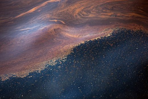
Gulf of Mexico Sea Floor Unstable, Fractured, Spilling Hydrocarbons

oil,water
© Getty ImagesPools of crude oil float on the surface of Gulf of Mexico waters at the site of the sunken BP/Transocean oil drill the Deepwater Horizon on April 27, 2010.
The Gulf of Mexico disaster has not gone away. In fact, it has grown exponentially since the main stream media stopped talking about it. According to the Gulf Rescue Alliance, an organization composed of scientists, medical professionals and seafood industry professionals, among others, the problem cannot be simplified to the damage already caused by the oil spill. It is worse, much worse.

The Real Agenda received exclusive information regarding the current state of the ongoing emergency in the Gulf of Mexico. The latest assessment performed by the Gulf Rescue Alliance reveals not only that the oil spill is still happening, but also that the Gulf of Mexico's sea floor grew more unstable since the explosion in 2010. Additionally, analysis provided by experts like BK Lim, shows that the geohazards developed that derive from the rolling leakage of toxic matter, combined with the on-going use of the highly toxic chemical dispersant called Corexit will most likely result in the permanent decline of marine life, while posing out-of-control public health risks, just as it did after the Exxon Valdez spill where the same chemical dispersants were used resulting in a rapid decline of the marine life until, for example, the Herring industry completely collapsed and has never recovered since then.

Cloud Lightning

Hurricane Jova bears down on southwest Mexican coast

Image
© NOAA.gov5 day forecast for Hurricane Jova from NOAA.gov
Hurricane Jova bore down on southwest Mexico Tuesday, prompting warnings along the coast, the National Hurricane Center in Miami said.

Jova, a Category 3 hurricane with maximum sustained winds of 115 mph, was about 150 miles southwest of Manzanillo and about 200 miles south of Cabo Corrientes, heading north-northeast at 6 mph, the center said in its 5 a.m. EDT advisory.

A hurricane warning was in effect from Punta San Telmo north to Cabo Corrientes. A tropical storm warning was posted for Lazaro Cardenas north to south of Punta San Telmo and north of Cabo Corrientes to El Roblito.

On its current track, the center of Jova was expected to be near the coast in the hurricane warning area Tuesday afternoon or evening, the center said.

Bizarro Earth

Oil spill is New Zealand's 'most significant' environmental disaster at sea

Wellington - An oil spill from a container ship stricken off New Zealand is now the country's "most significant maritime environmental disaster," a government minister said Tuesday.

Environment Minister Nick Smith issued the warning as the weather deteriorated, sending clumps of thick fuel oil on to nearby beaches.

Image
© Natacha Pisarenko / APA volunteer cleans a beach stained with fuel oil leaked from the Liberian-flagged container ship Rena in Tauranga, New Zealand, Tuesday.
The Liberian-flagged Rena has been stranded on a reef about 12 nautical miles off Tauranga on the east coast of the country's North Island since running aground on Wednesday.

As much as 385 of 1,879 tons of heavy fuel oil has already escaped and authorities have warned people off the beaches and told them not to eat seafood from the area.