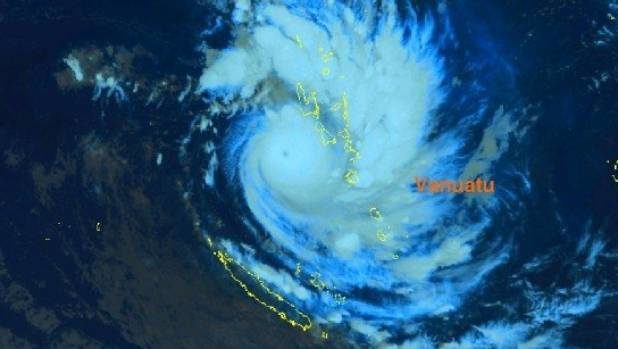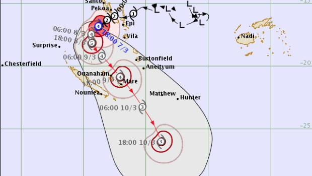
Tropical Cyclone Hola crossed islands in the South Pacific country overnight - and will make a path to New Zealand, MetService said.
The Fiji Meteorological Service said Hola had intensified to Category 4 strength between 6am and 7am (NZT). It had sustained winds of 165kmh and gusts of 230kmh.
Hola was expected to continue to intensify during the next 24 hours, and had the potential to become a Category 5 storm in that time.
During the next 24 hours, it was expected to be over the sea, then after that was expected to pass between Vanuatu and New Caledonia, affecting both those countries.

"The seas will remain very rough with heavy to phenomenal swells over Malampa, Sanma, Penama and Shefa provinces," the department said.
"Heavy rainfalls, thunderstorm and flash flooding over low lying areas and areas close to river banks including coastal flooding will continue to affect these provinces."
By 4am Hola had crossed the main islands of Vanuatu and was located to the west of the group. The Fiji Meteorological Service expected it to turn southeast overnight, taking it on a course that could affect some islands of New Caledonia and southern Vanuatu.
People had started to move to evacuation areas and safer buildings, such as churches.
STORM LIKELY TO HIT NORTH ISLAND
MetService tropical cyclone forecaster Micky Malivuk said strongest indications for now were that Hola would track just to the northeast of the North Island late Sunday into Monday, maybe just catching parts of Northland, Auckland, Bay of Plenty and Gisborne.
"The centre itself will move just offshore but they will still be experiencing heavy rain and strong winds."
The models would be able to develop a better idea of Hola's track once it recurved and started moving south-southeast, which was expected to happen overnight or into early Friday, Malivuk said.
So far, as well as the most likely indication that Hola would pass just to the northeast, some models were indicating it would miss New Zealand completely, while others were suggesting the centre would pass right over Auckland.
As long as Hola remained on its western track, it was a bit tricky to forecast when and where it would impact the country.
Meanwhile, the National Oceanic and Atmospheric Administration (NOAA)'s website said the weather system would intensify over the next three days, "with an initial westward track before a shift to the southeast that could see the system approach the northern island of New Zealand by early next week".
The Australia Bureau of Meteorology also said the weather system was tracking towards the southwest.
CYCLONES UNUSUAL
Niwa meteorologist Ben Noll said New Zealand was already above average with two ex-tropical cyclones so far this season, even as tropical cyclone activity in the Southwest Pacific was tracking below average.
Gita struck on February 20 and 21, after causing major damage in Tonga. At the start of February it was the remains of Fehi that did the damage in this country.
The average for New Zealand was 0.75 ex-tropical cyclones passing within 550kmh of Auckland each November to April cyclone season, Noll said.
If Hola made it to or near New Zealand that would be 400 per cent of normal
"That's definitely a large deviation from what would be considered normal," Noll said. But forecasters had expected New Zealand to have a normal to above normal season. "I don't think it's that far off from the expectation at this point."
To assess the season so far in the Southwest Pacific, Noll referred to something called accumulated cyclone energy, otherwise known as ACE.
That was represented by a number which takes into account maximum wind, how long a storm lasts, and how strong a storm is in terms of pressure.
Gita, which reached category 5 status, had 32 ACE points, the weaker Fehi 1.6, and by 11am Thursday Hola had 2.1.
With no tropical cyclones at the end of 2017, the ACE total so far for this season - starting November 1 - in the Southwest Pacific was 35.7. In comparison, the average for the season-to-date was 50.8, Noll said.
"While New Zealand has had an above normal impact, the Southwest Pacific so far as a whole is tracking near to below normal."
With Hola accumulating ACE points, the number for the season-to-date could climb into the 40s, taking this season closer to normal.


Reader Comments
to our Newsletter