Storms
S


Snowflake

Three feet of snow gets dumped on northern Michigan

Image
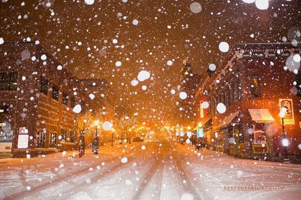
© lakesuperiorphoto.comThe big, wet flakes of snow fall on downtown Marquette on Monday, November 10, 2014.
A pre-winter chill, with the possibility of light snow flurries, has settled in over the metro Detroit area, but southern Michigan residents can be thankful they don't live further north.

Parts of the Upper Peninsula are buried in as much as 3 feet of snow this morning.

As of this morning, 36.1 inches of snow had fallen since Monday in Marquette County near Negaunee. Up to 2 feet fell in other parts of the Upper Peninsula with lower totals along the Lake Michigan shoreline, the Associated Press reports.

Detroit today will see highs in the upper 30s with perhaps a few flurries, said National Weather Service meteorologist Sara Schultz. A few more flurries are possible Thursday from the morning into the afternoon, and highs from now into the weekend are to be in the 30s with lows in the 20s.

Up North, meteorologist Justin Titus says a major winter storm system that brought all that snow to the U.P. has moved out of the area, but lake-effect snow of 8 to 15 inches is forecast along Lake Superior through Saturday, according to the Associated Press.
Cloud Grey

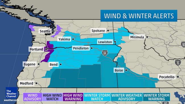
High winds, power outages in Pacific Northwest from powerful 'winterlike air mass'

Image
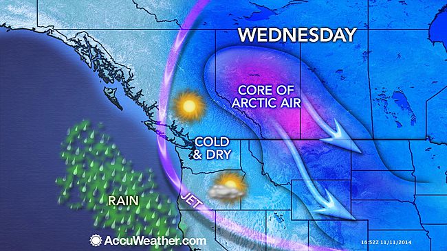
Strong winds broke out in parts of the Pacific Northwest Tuesday and Wednesday, prompting high wind warnings for parts of western Washington and northwest Oregon, injuring one person in Portland and blowing trees onto houses in the Seattle-Tacoma area. At least 66,000 customers were still without power Wednesday morning in the two states as winds continued to knock down trees and power lines.

The winds are the result of the same winterlike air mass that has plunged all the way south to the Gulf Coast and eastward into the Ohio Valley behind a powerful cold front. A powerhouse high-pressure zone over western Canada and the northern U.S. is also trying to literally push this frigid but shallow air through gaps in the Rocky Mountains and from there into the Northwest, where it faces a second obstacle in the form of the Cascade Range.

The high, whose central pressure was 1051 millibars (31.03 inches of mercury) over Canada's Northwest Territories Tuesday afternoon, has proven plenty strong enough to do just that. Winds began howling before sunrise Tuesday in the Columbia River Gorge just east of Portland, Oregon -- the most prominent gap in the Cascades, cutting a 4,000-foot-deep valley through the mountains.

Igloo

Arctic blast sets stage for winter storm to threaten the Northwest U.S.

Image
The blast of arctic air spreading across the nation will set the stage for a winter storm to threaten the Northwest later this week.

Frigid air will not only spend this week pouring across the eastern two-thirds of the nation, but will also continue to spill into the Northwest.

As the cold air expands southwestward, gusty winds will create even lower AccuWeather.com RealFeel® temperatures through Wednesday.

As the cold air squeezes through the Columbia Gorge, winds will pick up speed in a fashion similar to what happens between buildings in a city. Gusts of 40 to 60 mph can occur near the western mouth of the gorge into Wednesday.

The strongest winds will whip Troutdale, Oregon, with gusts of 50 mph expected in Portland.

Such winds could cause tree damage and power outages. Dangerous cross-winds will threaten high-profile vehicles, including those traveling Interstate-84 as it snakes along the Columbia River and the portion of I-5 in the Portland, Oregon, area.

As the winds die down later Wednesday, attention will then turn toward a new Pacific storm due to arrive late in the week.

While the storm will be far from the strongest to slam the region, the presence of the cold air will set the stage for snow and ice to fall outside of the mountains and create travel hazards.

Current indications point toward an icy mix developing along the I-5 corridor in northern Oregon and southern Washington Wednesday night through Thursday morning.

Cloud Precipitation

Two pensioners missing in Italy storms after landslide engulfed their home

Image
© Il MeteoTen people in Chiavari, Liguria, were brought to safety in a rubber dinghy as floods hit the town.
Two pensioners were still missing on Tuesday morning after a landslide engulfed their home in Liguria, prompted by the latest storm to hit north-west Italy.

The two elderly cousins were believed to have been at home when the landslide hit at around midnight in Leivi. Despite rescuers' efforts they have not been found, La Stampa reported.

Earlier in the evening it took the fire brigade two hours to save two women, one pregnant, from their nearby home after it was hit by a landslide.

A further ten people in Chiavari were brought to safety in a rubber dinghy, as torrential rain prompted streams and the River Rupinario to burst their banks.


Igloo

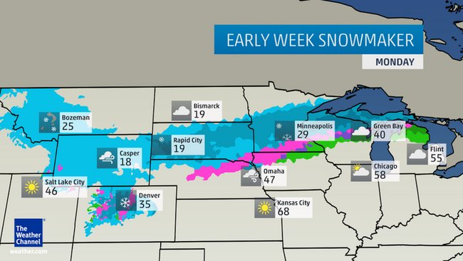
Winter storm Astro dumps heavy snow, strong winds and hammer South Dakota, Minnesota, Northern Wisconsin, Michigan

Image
Winter Storm Astro dumped the season's first snow in Bismarck, North Dakota Sunday, with 3.2 inches measured at the National Weather Service office. This first snow in North Dakota's capital city arrived about two weeks later than average. Up to 7 inches had accumulated in North Dakota, as of late Monday morning.

Webster, South Dakota, chalked up the state's heaviest total (8 inches) and patchy freezing drizzle had deposited a thin layer of ice on roads in parts of northern South Dakota. Parts of western and central Minnesota had measured up to 13 inches of snow as of early Monday afternoon.

The 13-inch total came from Kimball, near St. Cloud. Dr. Bob Weisman at St. Cloud State University had reported 7 inches of snow. Meteorologist reported 8.5 inches of snow had fallen in Forest Lake, Minnesota, a far northern suburb of the Twin Cities, as of 2 p.m. Monday.

Up to 9 inches of snow blanketed parts of southern and eastern Montana, including Red Lodge (9 inches), Glasgow (6 inches) and Glendive (4 inches). The Whitefish Ski Resort's Big Mountain Summit tallied 14 inches of snow in far northwest Montana. Drifts up to 2 feet around buildings were observed near Brusett, in northeast Montana.

Ice Cube

Northern Rockies snowstorm to expand to Minneapolis, Great Lakes

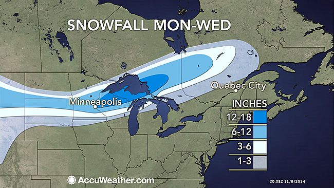
The snowstorm unfolding across the northern Rockies will spread a swath of snow to Minneapolis and the upper Great Lakes through the first part of the week.
Image
Before reaching the Great Lakes, the system is expected to deliver snow from the Rocky Mountains to the northern Plains with accumulating snowfall reaching as far south as Denver.

The snow will then begin to build into the northern Great Lakes, moving into the region on Monday and continuing into Tuesday night.

Due to the path of the storm, it appears as though some of the bigger cities around the Great Lakes, such as Chicago and Detroit, will miss out on the snow.

The heaviest snow is expected to focus on a zone stretching from northern Wisconsin to central Ontario. A foot or more of snow will fall over this area with localized pockets receiving as much as 2 feet of accumulation.

Gusty winds also accompanying this storm will result in blowing and drifting snow.

While blizzard conditions are not expected, winds gusting up to 30 mph can greatly reduce visibility, resulting in major travel disruptions.

This wind will also cause AccuWeather.com RealFeel® temperatures to be held to the teens and single digits on Monday in places such as Minneapolis, making it dangerous for people to spend extended periods of time in the outdoors without wearing proper clothing.

Snowflake Cold

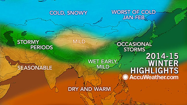
Swath of Winter storms extend from Turkey to Japan

While much of the tropical activity tends to diminish in the Northern Hemisphere during the winter, sometimes the western Pacific can remain active.
Image
"The cooler waters southeast of Asia will likely yield far less tropical activity in the western Pacific compared to last winter," AccuWeather Senior Meteorologist Jason Nicholls said.

Six of the eight named tropical systems struck the Philippines from November 2013 to February 2014. Super Typhoon Haiyan delivered a devastating blow to the Philippines in November.

Nicholls and AccuWeather Long Range Team expect no more than one named tropical system [tropical storms and typhoons] to directly affect the Philippines or to pass near Japan this winter.

Cold Air to Aim for Northeastern Areas

Cold air will make lunges toward the traditionally chilly winter locations of northeastern China and Manchuria.

According to Nicholls, "The most significant cold shots will occur during January and February but will tend to be brief."

By the end of the winter, the back-and-forth pattern should result in near-average temperatures from Beijing, China, to Seoul, South Korea.

Comparatively less frequent cold intrusions will result in above-average temperatures by the end of the three-month period from Shanghai and Hong Kong, China, to Tokyo, Japan.

Snowflake Cold

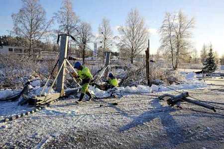
Snow storms cause huge power outage in Ostrobothnia, Finland

Image
© Str / Lehtikuva.Power company workers are repairing electric poles to restore power supply in Pietarsaari area on Wednesday.
Mercury dives to below 25 °C in Utsijoki

Snow storm caused massive power outage in Pietarsaari region of Ostrobothnia on Wednesday morning.

More than 40,000 customers of the energy company Herrfors were left without power in Pietarsaari, Uusikaarlepyy, Vöyri, Oravais and Kruunupyy areas.

The power outage in the network happened at around half past six in the morning and lasted for about an hour.

Meanwhile, the lowest winter temperature was recorded in Utsijoki.

According to the Met Office, a temperature reading of minus 25 degrees Celsius was recorded at Kevojärvi in Utsijoki following a cold wave on Tuesday night.


On the other hand, abundant snow had fallen in Kainuu since Tuesday night. Snow accumulated to more than 20 centimetres in some places. Road conditions were hampered in some places in northern Ostrobothnia.

Cloud Lightning

Two waterspouts filmed off Ligurian coast, Italy

Image
© YouTube/liguriainside
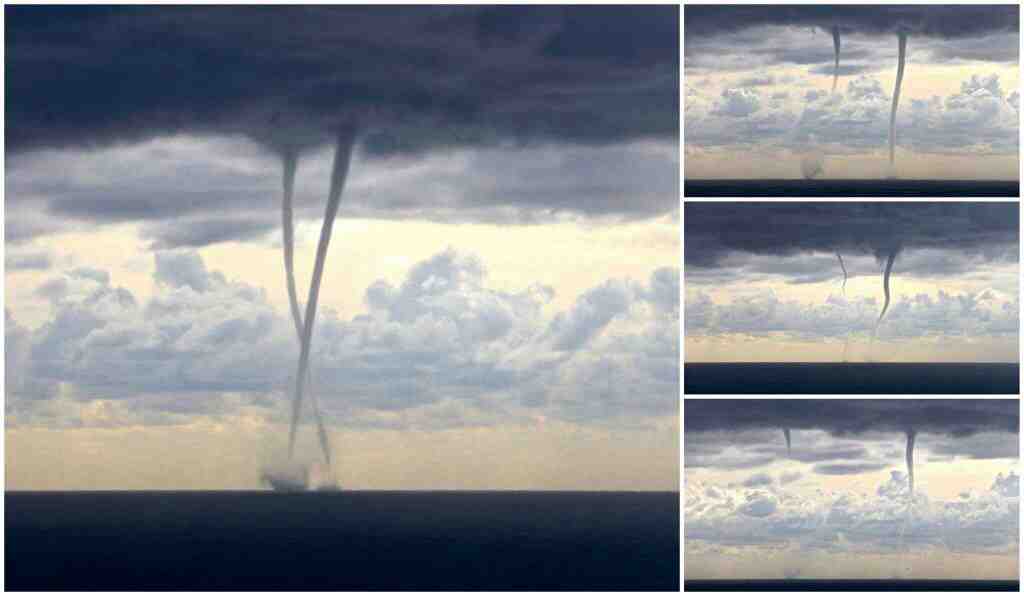
Two waterspouts formed simultaneously off the coast of western Liguria, Italy, on November 6, as a thunderstorm moved through the area. Both dissipated before reaching land. The waterspouts were viewable from Diana Marina, Cervo and Andora, according to a local report. This footage was recorded from Diana Marina.


Windsock

Quickly strengthening monster storm may be most intense ever for Alaska

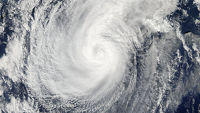
A powerful storm is slated to move over the Bering Sea this weekend, possibly becoming one of the most intense storms to ever impact the region.The former Super Typhoon Nuri is forecast to track northward into the Bering Sea, located in between Alaska and Russia, on Friday, losing its tropical characteristics as it does so.
Image
© Satellite Image/NASAVisible satellite image capture Typhoon Nuri as it churned over the West Pacific on Nov. 5, 2014.
At this point, the system will undergo rapid intensification, producing howling winds as the central pressure plummets to near record levels.Due to the massive size of the storm, impacts can be felt hundreds of miles away from the storm's center through much of the weekend.

Large waves and hurricane-force winds are expected to be the highest impacts with waves in some areas topping 45 feet Friday night and into Saturday.Waves this large can quickly turn deadly, tossing around ships sailing in the area.

Waves and swells are not expected to be nearly this high along the west coast of Alaska. However, they may still be strong enough to cause flooding and erosion in coastal areas.

Comment: Alaska's Aleutian Islands targeted from remnant of Typhoon Nuri as 'intense Sea Storm'