Storms
S


Cloud Precipitation

Rome on high alert amid severe weather - rainfall up to 110 millimetres in 24 hours expected

Image
Heavy rainfalls and strong winds have hit Rome since Wednesday night and hundreds of schools remained closed on Thursday after a severe weather warning was issued by local authorities. The whole capital city and surrounding areas were put on the highest alert, as more rainfalls up to 110 millimetres in 24 hours were expected, according to Italian civil protection's forecast.

Rome always proved to be particularly susceptible to flooding in case of heavy rains, given its old water network and infrastructures. Major traffic disruption was registered on Thursday morning. At least four major metro stations were flooded by rains and shut, and water swamped several roads in the historical centre and other districts.

The main highways to and from the city were also flooded, and the Rome's ring road GRA was jammed with traffic.

Snowflake

2 metres of heavy snowfall in Turkey - 36 village roads closed

Image
50 cm (20 inches) of snow in Artvin. On a plateau near Rize a car was stuck in 2 meters of snow.

According to Special Provincial Administration teams, the snow was 50 cm (20 inches) deep in higher elevations.

A written statement from the General Directorate of Meteorology asked citizens to be cautious due to the expected heavy snowfall in some provinces. It warned: 'Heavy Snow Coming!'

Artvin, Ardahan and northern districts of Rize and Erzurum expected heavy snowfall in the higher parts.

Image

Snowflake Cold

Maine snowstorm: 80,000+ still without power two days after a wicked Fall snowstorm knocked out electricity in Maine

Image
Utility crews continued to restore power across Maine Tuesday, two days after a wicked fall snowstorm knocked out electricity to a bulk of customers along the state's mid-coast.

While the number of customers without power dropped below 50,000 by evening, the outages forced election officials to make alternative plans for several polling places for Tuesday's midterm election.

There was also one death attributed to the snowstorm. Troopers say a Lubec woman died when her pickup truck went off the road and overturned in the Washington County town of Trescott. They said 28-year-old Danielle Moores lost control of her pickup truck about 6:30 p.m. Sunday during the heavy snow from the weekend storm. The truck came to rest on its roof in a bog. Moores died at the scene.

Cloud Lightning

Alaska's Aleutian Islands targeted from remnant of Typhoon Nuri as 'intense Sea Storm possible'

Image
While the former Super Typhoon Nuri sent meteorological jaws dropping earlier this week, its remnant may have another impressive chapter in store in the Bering Sea and Alaska's Aleutian Islands. The remnant of Typhoon Nuri is expected to join up with the polar jet stream and a very strong disturbance in the mid-latitude belt of westerly winds, as highlighted above.

Forecasts from both the European (ECMWF) and American (GFS) computer models continue to predict an extremely powerful non-tropical storm to develop from this merger over the Bering Sea, near the western Aleutian Islands of Alaska Friday into Saturday.

Windsock

Hurricane-force wind storm sweeps through Swiss Alps

Image
© Switzerland TourismTitlis mountain lift — closed for maintenance.
Hurricane-force winds swept through the Swiss Alps early on Tuesday registering as high as 187 kilometres per hour in the canton of Obwalden, weather services reported.

This wind speed was recorded at Titlis, a 3,238-metre mountain in the Uri Alps, Meteo Group and SRF Meteo said in news releases.

The high winds are due to a Foehn storm that began battering higher elevations late on Monday.

There were no reports of substantial damage.

Titlis is home to Europe's highest suspension bridge, a 500-metre-long foot bridge at 3,041 metres above sea level, 500 metres above the ground.

Snowflake Cold

Another shot of cold air, snow to hit Midwest and Eastern U.S.

Image
Another shot of cold air will follow a fast-moving storm forecast to sweep from the Midwest to the East during the second half of the week.

People from the Midwest to the East will need an array of outdoor gear into next week.

Before the chill hits, temperatures will moderate during the first part of the week over much of the eastern half of the nation.

Conditions will be favorable for storm cleanup early this week around the Chicago Lakefront and at midweek in northern New England. Waves washed over Lake Shore Drive in Chicago following a blast of snow on Halloween. Record snow amounts buried New England as the same storm pushed off the coast and ramped up. The milder air will also make raking leaves a little less painful from the Midwest to the Appalachians and Northeast.

The storm later this week will not be as strong as the system that hit the Midwest and East this past weekend. However, it will bring spotty rain and snow to parts of the northern Plains Wednesday then the Great Lakes on Thursday.

In the wake of the storm, winds will kick up, bringing in a quick dose of cold air and localized lake-effect snow to parts of the Upper Midwest.

Winds with the cold shot will not be as intense and more from the west in the wake of the storm around the Great Lakes. The southeastern shoreline of Lake Michigan will be hit with wave action, rather than Chicago during this round. The northwest flow will bring more lake-effect flurries and snow areas farther east over the Midwest when compared to this past weekend.

Cloud Lightning

South-eastern France hit by violent storms and floods once more

southeast france storms and floods
© France TV infoSouth eastern France takes a hit from extreme weather
Some fifteen departments in south eastern France were on alert on Tuesday as storms swept through the region. Residents in the Ardeche were some of the hardest hit as rivers burst their banks.

Gale force winds and heavy rain lashed south eastern France on Tuesday leaving weather alerts in place for 15 departments.

On Monday night the severe weather caused havoc in the Ardeche department and left over 6,000 homes without power. Firefighters were called out nearly 100 times to deal with incidents.

"We have an enormous amount of damage, with walls collapsing onto roads," said deputy mayor of an Ardeche village Michel Aymard, who said it was the third time in two months the region had been hit by devastating floods.

Comment:

South of France under flood waters again
Southern France put on maximum storm alert, risk of flash-flooding


Snowflake Cold

Already an early U.S. winter? A foot of snow in Maine, record unprecedented early-season snow in South Carolina

Image
Up to a foot of snow has fallen in Maine from a storm system that earlier brought an unprecedented early-season snow to parts of South Carolina on the first day of November.

Bangor, Maine, reported 12 inches of snow as of 2:50 p.m. EST Sunday. Scroll down for more on the snow forecast for New England.

Snow was observed Saturday as far south and east as Charleston, South Carolina, the earliest flakes on record in the city. This occurred less than three days after a string of four straight days in the mid-upper 80s. Places like Folly Beach and downtown Charleston picked up a trace of snowfall.

Even more stunning were the snowfall amounts in the South Carolina Midlands. Up to 4.5 inches of snow fell in Red Bank, just west of Columbia. Red Bank is only about 350 feet above sea level.

A couple of inches of snow coated grassy areas and some roads near Greenville and Pelion, South Carolina. Power lines were downed in Greenville, Greenwood, and Lexington Counties due to the combination of strong winds and wet snow accumulations.

Comment: Record snowfall prompts road closures and evacuations from Great Smoky Mountains National Park


Cloud Lightning

Tropical Storm Vance threatens Mexico's Pacific coast, could strengthen to hurricane by Sunday

tropical storm vance
Tropical Storm Vance continues to churn over the waters of the eastern Pacific Ocean after developing on Thursday afternoon.

The AccuWeather.com Hurricane Center is keeping a close eye on the system, located several hundred miles south-southeast of Acapulco.

Further strengthening will occur through this weekend as the tropical cyclone remains over the warm waters of the eastern Pacific and in an environment that lacks disruptive wind shear, which can shred apart tropical systems as evident with Tropical Cyclone Nilofar.

The system is likely to strengthen into a hurricane by Sunday.

Cloud Precipitation

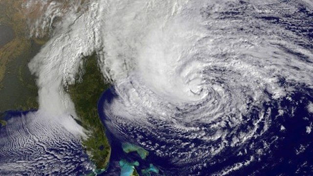
2 years on: Hurricane Sandy inspires storm of climate research

Hurricane Sandy
© www.vanityfair.comNortheast's epic storm, Hurricane Sandy
The two years that have passed since Hurricane Sandy crashed into the New Jersey shoreline have not been enough time for scientists and researchers to make much headway on the hows and whys of the Northeast's epic storm. But that's not because they aren't trying.

In fact, Sandy has spurred an unprecedented amount of research, attempting to tackle the questions about what role climate change might have played in producing or worsening the storm, how global warming might influence similar storms in the future, and why the storm caused so much damage - $19 billion in the New York City area alone. "It'll be one of the most studied storms," said Gary Lackmann, an atmospheric scientist at North Carolina State University who has looked into the role warming might have played in guiding Sandy's track and intensity.

Here, Climate Central takes a look at some of those research avenues exploring the role climate change played in Sandy and how the so-called superstorm impacted our evaluation of current and future coastal risks.
flooded
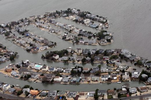
© www.pressofatlanticcity.comAtlantic City during temporary sea rise.
Of Sea Level Rise and Storm Surge

The clearest connection between climate change and Sandy's impacts is sea level rise. Warming oceans and melting land ice have contributed in large part to the nearly 12 inches of sea level rise in the New York area over the past 100 years, a rate faster than the global average of about 8 inches.

Sea level rise is contributing to coastal erosion in some places such as the Jersey Shore, but Philip Orton, an oceanographer at the Stevens Institute for Technology in Hoboken, N.J., said that how it interacted with storm surge - the wall of water that hurricanes and other storms push ashore - is what helped drive much of Sandy's damage. And the future 1-2 punch of storm surge and sea level rise could further reshape the physical and social landscape around New York and New Jersey. "Sea level rise is very uncertain so that's part of the problem for long-term planning," Orton said.

Comment: Due to a negative phase, in the constantly changing pressure gradient of the North Atlantic Oscillation (NAO), a high pressure ridge over Greenland blocked Sandy's NE trajectory. Plus, a dip in the jet stream and a surface cold front turned Sandy westward into the U.S. East Coast. How does that work?

A high pressure over Greenland creates a counterbalanced low pressure zone to the south and causes colder weather patterns in lower latitudes. Global ocean oscillations, contributing their cyclic and alternating patterns of "highs" and "lows, influence east-west wind troughs and cause or contribute to continental droughts, floods, extreme temperature fluctuations and migrations of wildlife habitats. The extreme swings of the NAO are part of the complex atmospheric/ocean dynamics of the North Atlantic, which include sea-surface temperature anomalies, the strength of the Gulf Stream, atmospheric wave structure and the distribution of sea ice and icebergs. A statistical relation between Arctic Sea ice loss and occurrences of the negative (blocked) NAO phase has been observed in recent decades. A northern high pressure zone increases temperatures causing ice melt. These interactions are poorly understood in reference to their magnitude of effect over contributing systems, vast distances and time.

Add in the following: Ocean warming due to plate tectonics, increasing methane release, a slowing earth rotation creating friction between the mantle and the crust uping earthquakes and volcanic activity, a rise in electrical phenomenon and interaction in the solar system, tropical climate zones measurably moving towards the poles* pushing more warm moisture into higher atmospheres of frigid temperatures resulting in massive winter storms...a recipe for the rapid onset of vast amounts of ice and snow. (Every drop of water creates 10 times its volume upon freezing.)

*According to NOAA, a poleward shift of mid-latitude storms (as in Sandy) is occurring. Are we on track for the next ice age? Is it only a matter of time and confluence?