Storms
S

Cloud Lightning

New South Wales, Australia battered by storms all week, more on the way

sydney radar
© NewsComAu Sydney radar this Friday arvo. Bring your brolley!
The radar image says it all. A big blob of red, yellow and blue heading your way.

If you've been in Canberra, Sydney or Brisbane in recent days and weeks, you've seen storms just about every afternoon.

This weekend, more thunderstorms, hail and powerful winds are expected in New South Wales set to last until early next week. Saturday is likely to be the worst day with heavy rains across one third of the state.

It comes after three days of severe weather in New South Wales that saw the State Emergency Service receive about 300 calls for help overnight and has led to thousands of volunteers being put on standby.

Comment: Australia is not getting a break this week - these storms are hitting just after two powerful thunderstorms in years hit Brisbane:

SOTT EXCLUSIVE: Worst Supercell thunderstorm in decades hits Brisbane, Australia and injures 39 people


Cloud Grey

Typhoon Hagupit triggers one of largest peacetime evacuations in Philippines

evacutations typhoon hagupit
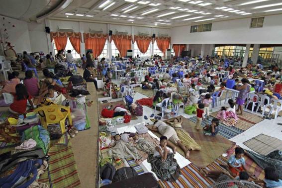
© Reuters People take shelter inside a evacuation centre after evacuating from their homes due to super-typhoon Hagupit in Surigao city, southern Philippines December 5, 2014.
Around half a million people fled coastal villages and landslide-prone areas in the central Philippines on Friday, a day before a powerful typhoon was expected to hit the island nation where thousands died in a storm 13 months ago.

Typhoon Hagupit weakened slightly as it churned slowly across the Pacific, dipping below the category 5 "super typhoon" level, the Philippine weather bureau PAGASA said, but was likely to remain destructive when it hit land on Saturday.

Philippine Airlines and Cebu Pacific cancelled more than 150 flights to central and southern Philippines on Friday and Saturday. Ports shut across the archipelago after the coastguard suspended sea travel.

"Over 100,000 families are already in evacuation centers," said Corazon Soliman, Social Welfare secretary. "Multiply it by five (persons per family), that's 500,000," she said, adding that most of the residents had volunteered to leave.

Comment: People are taking no chances as most remember super Typhoon Hayain which was said to be the most powerful typhoon or hurricane in recorded history.

10,000 feared killed in Philippines by super typhoon Haiyan

Super typhoon Haiyan makes landfall in the Philippines


Snowflake

Waist-deep snow in China with the most severe snowstorm seen in years

Image
The snow is up to 3 feet (90 cm) deep, leaving residents struggling to open doors.

A blizzard lasting more than 60 hours hit Fuyuan County, a border town in northeast China's Heilongjiang Province on Thursday.

Local communities banded together to clear snow from roads, and the county government said a contingency plan is in place to relieve economic stresses due to the snow.


Ice Cube

Dramatic evacuation of Hohe Wande because of ice storm in Austria

Image
© einsatzdoku.at
In the last few hours on Wednesday afternoon, all access to the Hohe Wand was cut off by ice-covered boulders and broken tree branches, as a result of the ice storm.

Police and fire departments were busy all morning visiting residents living in the area to ask them to leave their homes, many of which are threatened by falling trees.

Some residents left voluntarily, while others refused to leave. Some elderly residents had to be evacuated for medical reasons.

Comment: See also: Rare ice storm strikes Waldviertel in Austria


Cloud Precipitation

Wrecks, flooding, mudslides slam California as rain finally comes

Image

Rain pelted the Bay Area for the fifth consecutive day
on Tuesday, leading to a flurry of car wrecks, flooding and mudslide watches amid an otherwise welcome break from California's severe drought.

Flashing lights and sirens were common on the highways, with crashes reported before the sun came up on Interstate Highway 880 in Hayward and Highway 17 near Santa Cruz.. Flooding appeared in parts of San Francisco, including on northbound Interstate 280 at the Cesar Chavez offramp and the Ellis onramp at southbound U.S. Highway 101, which had a puddle that stretched 40 feet long and 15 feet wide.

Ice Cube

Freezing rain blankets Budapest causing power outages to 40K homes

Image
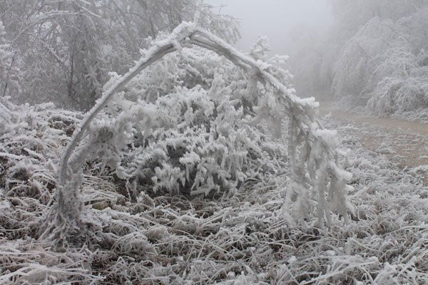
The entire forest in the hills at Pilis, south-east of Budapest, was covered in cloud and fog, freezing the rain and fog solid on the branches.
About 40,000 homes on the outskirts of Budapest went without electricity on Tuesday as freezing rain blanketed the area and falling trees cut power lines, Hungary's Disaster Relief Agency said.

Heavy branches fell and entire trees toppled as ice as thick as 10 centimeters (4 inches) coated them, threatening entire forests in altitudes above 400 meters, according to people who ventured to higher-lying areas.

Forestry services closed off large tracts of land located higher than 400 meters above sea level to prevent injuries. No deaths or injuries have been reported.

One forestry worker who visited the Borzsony Mountains north of Budapest said the woods echoed with loud cracks and hissing sounds as branches and trunks gave way under tons of ice.

Ice Cube

Rare ice storm strikes Waldviertel in Austria

Image
© APA/FF Ottenschlag/FichtingerFirefighters preventing a tree from damaging a power line.
The fire service was called out more than 200 times over the weekend in the district of Zwettl (Lower Austria) as a rare ice storm hit the region, bringing chaos with layers of frozen ice in trees.

Firefighters have been busy clearing away hundreds of trees from the vicinity of homes and power lines. The trees' branches had been bent almost double by the weight of the ice. The area near Ottenschlag has particularly been hit hard. A combination of very low temperatures and high humidity caused many layers of thick frost to form into heavy ice.

Motorists in the region have been asked to exercise extreme caution due to icy conditions on the roads. Northeast Fire Department spokesman Franz Resperger described on Sunday how many trees were destroyed by the ice, including some with trunks more than a meter in diameter.


Bizarro Earth

Southern France recovers from the worst flooding it's seen in years

Image
As southern France recovers from the worst flooding it's seen in years, The Local takes a look at some of the most shocking images of the damage done by the forces of nature. The latest victim was a 73-year-old man who died of heart failure in Rivesaltes, in the Pyrenees-Orientales region, when trying to force his car through a big dip in a road that was flooded.

Along the banks of the Agly river in the same region, some 2,800 people had been evacuated by late afternoon Sunday, the government office there said. The flooding was considered already more serious than deadly overflows in 1999 and "we are evacuating residents within 200 metres (yards) of either side of the river," the government said.

The prime minister's office dubbed the flooding "exceptional" in a statement but said "the situation is under control."

Cloud Lightning

SOTT EXCLUSIVE: Worst Supercell thunderstorm in decades hits Brisbane, Australia and injures 39 people

Supercell thunderstorm hits Brisbane
© Bureau of MeteorologyRadar image of the supercell storm that hit Brisbane.
Deja vu or what! Only a week after one of the worst thunderstorms in years hit Brisbane, then another massive storm arrives. This time a destructive supercell thunderstorm hits Brisbane. Here is a report from PressTV:

Nearly 40 people have been injured after a powerful storm hit Australia's third largest city of Brisbane.


The storm struck southeast Queensland on Thursday, with winds moving over 140 kilometers per hour, before reaching Brisbane and injuring 39 people there.

Only 12 of those injured have been hospitalized. Reports say there were about 6,000 lightning strikes.

As a result of the storm, described as being the worst in decades, a number of houses, trees and cars were damaged, while several streets were also flooded.

According to Australian officials, some 100,000 homes have also been left without electricity.

Australian Minister for Energy and Water Supply Mark McArdle said staff members with electric power distribution company Energex and Ergon were working to restore power.

Cloud Precipitation

Up to 9 inches of rain across Central Florida

Image
© AccuWeather
As the rain continues to fall across Central Florida, temperatures will steadily drop into the 50s by this afternoon due to a passing cold front, meteorologists say.

Some areas in Brevard and Volusia counties saw 7 to 9 inches of rain since Tuesday morning. As for Orange County, at least 6 inches have fallen in the attractions area, Windermere, Pine Hills and Bithlo. And it's not done raining yet, according to the National Weather Service in Melbourne. A flood watch remains in effect for Volusia, Brevard, Lake, Orange and Seminole counties through noon.

"[The rain] is slowly going to taper off through late morning," meteorologist Tony Cristaldi said. In Volusia County, one of the hardest hit areas Tuesday night was New Smyrna Beach with crews of Public Works working all hours to dry the streets. Five pumps were helping clear water throughout the city, with two pumps just on Columbus Avenue, which historically gets the most damage, said Holly Smith, spokeswoman for the city.