Storms
S

Cloud Precipitation

US: Northwest storms bring heavy rain, strong winds through Christmas; blanket interior West with snow

Image
As the train of storms from the Pacific Ocean continues, rounds of rain and mountain snow will fall on areas from the Northwest to the Intermountain West and Rockies through Christmas Day.

A strong storm will affect the Northwest this weekend with gusty winds, heavy low-elevation rain and high-elevation snow.

A second storm will roll ashore on Tuesday with falling snow levels in the Northwest and heavy snow farther inland in the West.

Northwest Storm to Unleash Heavy Rain, Strong Winds This Weekend

According to AccuWeather Meteorologist Brian Lada, "The worst conditions this weekend will hit from the Cascades to the Pacific coast."

A general 4-8 inches (100 to 200 mm) of rain will fall from the upper Oregon coast to Washington's Olympic Peninsula and the southwestern part of Vancouver Island, British Columbia.

A general 2-4 inches of rain are forecast along Interstate 5, from Eugene and Portland, Oregon, to Seattle and Tacoma, Washington. Similar rainfall with locally higher amounts are possible along the west-facing slopes of the Cascades in Oregon and Washington.

Enough rain will fall to raise the risk of mudslides and flash and urban flooding. Small stream flooding is possible due to melting snow and heavy rain on the intermediate elevations of the Cascades.

Gusty winds will accompany the heavy rain, raising the potential for flight delays and localized power outages.

Comment: Superbomb winter storm predicted for Northeastern U.S. at Christmas


Windsock

Series of fast moving storm systems forecast for British Isles, Northern Europe

Image
A series of fast-moving storm systems will continue the theme of unsettled weather from Ireland and the United Kingdom through northern Europe through Christmas.

While no one particular storm will cause widespread damage or travel disruptions, each will produce showers, gusty winds and put temperatures on a roller coaster ride.

The showers will occasionally occur as or be mixed with snow in the higher terrain of the British Isles, as well as parts of Scandinavia and northeastern Europe.

Gusty winds will howl even when dry weather prevails, especially near the coastlines.

The next storm AccuWeather meteorologists expect to bring significant impacts will make its presents felt Sunday night and into Monday as low pressure develops in Scandinavia.

This storm system will first increase winds across the United Kingdom and Ireland on Sunday and Sunday night. Gusty winds will become more widespread on Monday as blustery conditions advance across much of northern and eastern Europe.

Not only will this bring system bring windy conditions, there will also be rainy conditions along the length of a frontal boundary across the region. Snow and ice is expected in eastern Europe as moisture pushes into colder air.

Comment: It's kind of interesting that Donbass is left out of these storms...


Cloud Precipitation

Supertyphoon shifted 177-ton boulder 150 feet

University of Cologne and University of the Philippines researchers said the boulder is the largest ever documented to have been moved by a storm.

Image
© Max Engel/University of CologneThis 177-ton boulder was shifted about 150 feet by Supertyphoon Haiyan.
Supertyphoon Haiyan set a world record when it touched down in the Philippines by moving a 177-ton boulder a distance of about 150 feet.

Max Engel, a geoscientist at the University of Cologne in Germany, and colleagues from his college and the University of the Philippines' Marine Science Institute said they looked at satellite photos from before and after the typhoon's landfall in the Philippines in November 2013 and determined the boulder, weighing more than 25 adult African elephants, had been moved about 150 feet along a beach by the Haiyan's tsunami-like waves.

Snowflake

Major winter storm targets Japan; heavy rain, snow, typhoon strength winds

Image
© MTSAT/UW-CIMSS on December 16, 2014.
Japan Meteorological Agency (JMA) said a rapidly developing low-pressure mass is expected to bring heavy rain, snow and strong winds which will affect almost entire Japan on Tuesday and Wednesday, December 16 and 17, 2014.

Heavy storm conditions, high waves, floods, disruption of transport system and avalanches are expected as a result.

JMA called for particular readiness in Hokkaido for potential violent snow storm of magnitude seen "once in a few years". Maximum instantaneous winds reaching 108 - 126 km/h (67 - 78 mph) are forecast nationwide except for Okinawa, Amami and some other regions.

The Kuril Islands will see wind gusts eclipse typhoon strength and could approach 130 - 160 km/h (80-100 mph) Tuesday night and into Wednesday.

According to the JMA, two low-pressure masses, one over the Sea of Japan and the other over Honshu, are expected to grow fast and move northeast on Tuesday, eventually forming an atmospheric pressure distribution typical to winter over Japan. (JT)

The two masses will converge Wednesday over Hokkaido and grow further, creating a situation that will cause a strong cold airstream to continue to move toward Japan until Thursday.


Meteorologist Robert Speta of the WestPacWx said heavy rainfall could trigger localized flooding on Japans Pacific coast. This storm acts a lot like the sea effect snow event we seen this past weekend in Tohoku and Hokoriku.

"To put it in perspective this storm will have a deeper pressure and stronger gradient than the one on March 4, 2013 that killed nine in Japan," he said.

Comment: Japan storm impact:


Cloud Precipitation

Record nine inches of rain drench San Francisco

Image
9.14 inches of rain has fallen on San Francisco so far in December 2014, exceeding levels not seen in more than 165 years of record keeping.
Major cities in the Bay Area are experiencing record rainfall during the first half of December, the National Weather Service said Tuesday.

National Weather Service meteorologist Charles Bell said:
"It's the wettest start ever for December."
San Francisco has seen more than 9.14 inches of rain through early this morning. The previous record of 7.10 inches was set in 1889. Data go back as far as 1849, Bell said.

Bizarro Earth

Landslides destroy village in Indonesia, killing at least 17 people

landslide indonesia
© REUTERS/Idhad Zakaria/Antara FotoIndonesian soldiers and rescue team members lift a cattle trapped in the mud after a landslide hit the village of Sampang in Banjarnegara, December 13, 2014
A landslide destroyed a remote village in Indonesia, killing at least 17 people, an official said on Saturday, as rescuers used their bare hands and sticks to search through the mud for scores of missing in the absence of heavy-lifting equipment.

Hundreds have been evacuated from around Jemblung village in the Banjarnegara regency of central Java, about 450 km (280 miles) from the capital, Jakarta, where media pictures showed a flood of orange mud and water cascading down a wooded mountainside after Friday's disaster.

Mudslides are common in Indonesia during the monsoon season, which usually runs from October until April. Large swathes of forest land, power lines and houses were buried.


Cloud Precipitation

California storm drops 3 inches of rain in an hour

Image
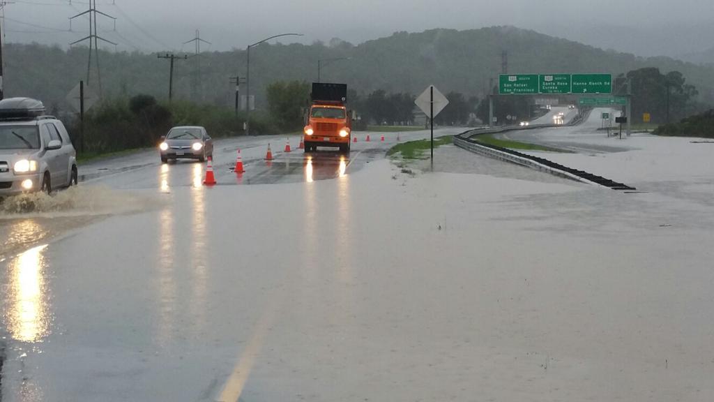
© Randee DeasonHwy 37-W near Novato, the connector to Hwy 101 North and South shutdown by flooded roadway
The storm dubbed the Pineapple Express by some media outlets hit wide areas of northern and central California yesterday, 11 December 2014.

US National Weather Service (NWS) say that 2.91 inches (73 mm) of rain was recorded in just one hour on the Big Sur coast yesterday. During the 24 hours of 11 December, 3.55 inches (90 mm) of rain fell in the San Francisco Bay Area. For San Francisco, it was the second wettest 11 December on record:
@NWSBayArea

#SF calendar day rainfall Dec 11th was 3.40" & now 2nd wettest daily total ever for the 11th. Dec 11th '95 daily record 3.61" holds. #CAwx


Comment:

Similar to Sao Paulo, Brazil, California had been suffering from extreme drought. In both, cases extreme rains have arrived within the past week causing severe flooding. These changes in weather seems to be indicative of worldwide weather swings that will in all likelihood continue to become more extreme in the future.

Brazil drought crisis deepens in Sao Paulo and other areas

Extreme flooding in Sao Paulo, Brazil

New study finds California drought worst in 1,200 years


Cloud Lightning

UK 'weather bomb' brings hundreds of lightning strikes, and power outage to 17,000 homes

weather bomb ireland
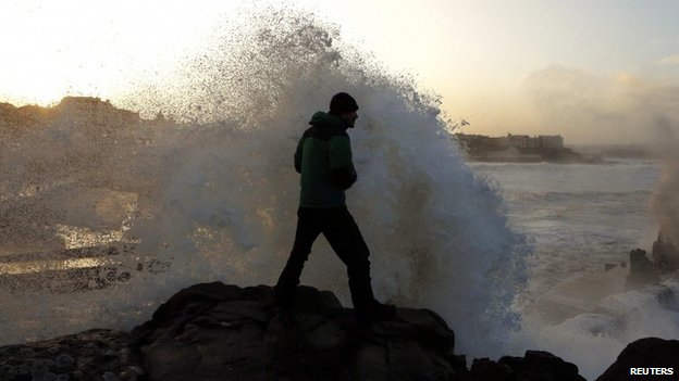
© ReutersThe storm brought powerful waves to UK coasts, including here at Portstewart in Northern Ireland
High winds and huge waves are affecting north-western parts of the UK as bad weather hits power supplies and travel.

The "weather bomb" has brought hundreds of lightning strikes, temporarily cutting power across the Western Isles, affecting 17,000 homes.

The Met Office has warned parts of Scotland and Northern Ireland to "be prepared" as the rapidly developing storm threatens gusts of up to 80mph.

Wind speeds are expected to peak on Wednesday afternoon and early evening.

Comment: The UK was battered only 2 weeks ago from another huge storm bringing high winds and floods and is expecting one of the worst winters in decades, but the severe weather has been besieging the entire globe. Watch the most recent SOTT Earth Changes Summary for a glimpse of nature's ferocity:


Windsock

San Francisco expecting 'storm of the decade' - hurricane-force winds, torrential rain

Image
© CBS
Winds above 74 miles per hour in hills above 2500 feet, and 80 miles per hour in the mountains are forecast for Thursday in what could be the storm of the decade according to Bay Area meteorologists.

The computer models are able to break down the exact time of highest danger. By mid-morning Thursday, models indicate winds peaking at 74 miles per hour sustained, not gusts, above 2500 feet. Above 5,000 feet the forecast is for 80 miles per hour. Along the coast, 60 mile per hour winds are forecasts, with higher gusts. The flatter areas around the bay will have widespread gusts from 40 to 50 miles per hour.

KPIX 5 chief meteorologist Paul Deanno said, "Given the long-term drought and short-term saturated ground, many trees will lose the battle with the wind on Thursday."

Deanno compares this week's storms to other significant events saying, "For those of us who have lived here for a while, the potential of this storm is comparable to the ones in January 2008 and February 1998, both of which caused widespread wind & flooding damage. As always, the forecast can change."

The National Weather Service has issued a whopping 15 separate warnings and advisories for the system including a Flash Flood Watch, Gale Warning, Hazardous Seas Advisory, and High Wind Watch.

Rainfall amounts above eight inches are forecast for the coastal ranges, triggering the Flash Flood Watch, an official notice to be looking for potential flooding. During the storm, these alerts will change from watches to warnings as actual floods begin occurring.

A hurricane, though only used to refer to tropical storms, is declared when sustained winds reach 74 miles per hour, and that level of wind is predicted for Thursday, along with rainfal amounts of over half an inch per hour, and if the storm slows, it could reach one inch per hour, causing serious flooding in the Bay Area.

Comment: To see how truly bizarre our weather is becoming, check out the latest monthly SOTT Earth Changes Video Summary.


SOTT Earth Changes Video Summary - November 2014

Also read Earth Changes and the Human-Cosmic Connection for more on the science behind the crazy weather we've been having here on the big blue marble.


Cloud Lightning

Typhoon Hagupit destroys 2500 homes, death toll rises to 27

typhoon hagupit
The death toll from Typhoon Hagupit, the latest natural disaster to hit the Philippines, has risen to 27; around 2,500 homes have been totally or partially destroyed by the storm, which is losing its destructive force and weakening into a tropical storm.

According to Reuters, 27 people have been killed and around 2,500 homes have been totally or partially destroyed by Typhoon Hagupit in the Philippines.

"We now have a total of 27 dead, most of them in Borongan, in Eastern Samar," the news agency quotes Richard Gordon, chairman of the Philippine Red Cross as saying, adding that most of the dead drowned in floodwaters.

Comment: The Philippines seems to be in the cross-hairs lately as this is the third tropical storm in the past few months:

Tropical storm Fung-wong hits the Philippines, Taiwan with torrential rainfall, flooding - 13 dead

Tropical storm Rammasun threatens Philippines; intensifying to typhoon by mid-week