Volcanoes
S


Attention

Over 100 earthquakes at Copahue volcano in one day, Chile

Copahue volcano
© AFP PHOTO / Antonio HuglichCopahue volcano
Is the Copahue volcano entering a new eruptive phase?

The volcano was hit by 103 earthquakes between December 12 at 10:17 local time (13.17 GMT) and December 13 at 1:09 local time (4.09 GMT), so less than 1 day. Insane.

103 seismic events rattled the Copahue volcano during last week-end as reported by the Service National of Geology and Mining of Chile (Sernageomin).

The earthquakes occurred 12 kilometers from the main crater at depths close to six kilometers underground.

The most powerful tremor was a M3.1 and happened at 12:57 local time (15.00 GMT) on Saturday.

Bizarro Earth

Earth's day is getting longer - Rotation is slowing down

Scientists reveal that the rotation of Earth's core holds a clue to understanding global sea-level rise.

Mathieu Dumberry
© University of Alberta
Scientists are studying past changes in sea level to make accurate future predictions of this consequence of climate change, and they're looking down to Earth's core to do so.

"In order to fully understand the sea-level change that has occurred in the past century, we need to understand the dynamics of the flow in Earth's core," says Mathieu Dumberry, a professor in the Department of Physics at the University of Alberta.

The connection is through the change in the speed of Earth's rotation. Meltwater from glaciers not only causes sea levels to rise, but also shifts mass from the pole to the equator, which slows down the rotation. (Picture the Earth as a spinning figure skater. The skater moves his or her arms in to spin more quickly or out to slow down.) The gravity pull from the Moon also contributes to the slowdown, acting a little like a lever brake. However, says Dumberry, the combination of these effects is not enough to explain the observations of the slowing down of Earth's rotation: a contribution from Earth's core must be added.

Bizarro Earth

Looming threat of volcano disasters in Auckland

Auckland Volcanoes
© Victoria University of WellingtonJenni Hopkins with a map showing Auckland's volcanic field.
Rangitoto, Mt Albert, Lake Pupuke, Orakei Basin, Mt Eden and One Tree Hill are some of Auckland's most familiar landmarks. But they are also reminders of the city's fiery history and the looming threat of future disasters.

A clearer understanding of the risk posed by a new volcanic eruption in Auckland has emerged from doctoral research undertaken by a student at Victoria University of Wellington.

Jenni Hopkins, in collaboration with GNS Science and the University of Auckland, has reconstructed the eruptive history of Auckland's volcanic field, which comprises more than 50 craters dating back around 200,000 years. While currently dormant, the field is expected to erupt again from a new site within potentially as little as a few hundred years.

"The 53 volcanoes in Auckland are almost entirely monogenetic, which means they generally only erupt once," says Jenni. "But what was previously unknown was the order in which they erupted—I wanted to find that out so that we could establish the characteristics of the field and get an idea of what a future eruption might be like."

Attention

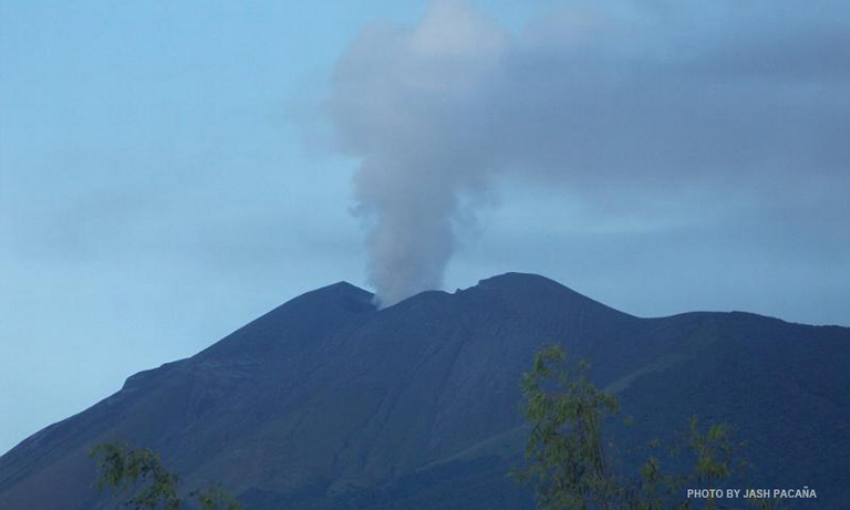
Kanlaon Volcano spews ash cloud in the Philippines

Kanlaon volcano
© Jash PacanaKanlaon volcano (file photo)
An ash eruption occurred at Kanlaon Volcano early morning on Friday, the Philippine Institute of Volcanology and Seismology (Phivolcs) said.

In a bulletin posted 8 a.m., Phivolcs said in the past 24 hours, four volcanic earthquakes were recorded, two of which were accompanied by a low-energy ash eruption.

The ash eruption occurred at 5:13 a.m. and lasted for a minute based on visual observation.

"This produced a grayish to dirty-white cloud of ash reaching a height of 600 [meters] which then drifted southwest," Phivolcs said.

Traces of ash were observed on the southwest slope of the volcano along San Jose, La Castellana, it added.

Alert Level 1 is still hoisted over Kanlaon Volcano, as it remains in an abnormal condition and is in a period of current unrest.

The Phivolcs reminded local government units (LGUs) and the public that entry into the 4-kilometer radius Permanent Danger Zone is strictly prohibited "due to the further possibilities of sudden and hazardous steam-driven or phreatic eruptions."

It said civil aviation authorities should also advise pilots to avoid flying close to the volcano's summit, warning that airborne ash from a sudden eruption can be hazardous to aircraft.

Comment: The rate of volcanic activity continues to increase, as the number of volcanoes erupting right now is greater than the 20th century's YEARLY average.


X

Mud volcano erupts near Leninsky, Crimea

Mud volcano
© Vestnik Kavkaza
An eruption of a mud volcano has occurred in the Leninsky district of Crimea near the village of Novoselovka. The mass of soil stopped at a distance of 100 meters from the village.

The information was announced at a meeting of the inter-agency staff on eliminating the consequences of the emergency situation caused by the energy crisis by the head of the Lenin district administration Alexander Machussky, Tass reports.

He also made a request to send experts to the area in order to assess the current situation.

Attention

New explosion of ash at Turrialba Volcano in Costa Rica

Turrialba Volcano
© RSN/UCRAn ash explosion at Turrialba Volcano lasted for about 10 minutes, the University of Costa Rica’s National Seismological Network reported.
Costa Rica's Turrialba Volcano, located 50 kilometers east of San José, erupted at 1:12 p.m. on Monday and launched ash and vapor into the air for about 10 minutes, experts with the University of Costa Rica (UCR) and the National University (UNA) reported.

This is the second event this month after another 10-minute explosion recorded on Dec. 7. also spewed ash and gases into the air.

Experts from UNA's Volcanological and Seismological Observatory of Costa Rica (OVSICORI) reported the explosion reached just under 400 meters in height.

UCR's Mauricio Mora at 2:30 reported there were no more explosions. Mora was conducting an inspection in the volcano's surrounding areas and said experts are evaluating whether the explosion was an isolated event or is part of an eruptive process.

OVSICORI on its website reported that current wind conditions likely would take the ash west, and residents northeast of the capital - such as in Coronado and Sabanilla - could experience ash falling on their roofs and properties.

Turrialba Volcano has seen constant activity that in the past five years has prompted several evacuations of residents and farm animals.

Comment: Volcanic activity increasing. See: 18 active volcanos worldwide; new activity, unrest at 5 more


Camera

Guatemala's Fuego volcano enters new eruptive phase, increasing activity

Fuego volcano
© Via instagram/marco_ovandoWaking up to this!
An active volcano in Guatemala has entered a new eruptive phase, sending huge lava fountains into the air. With no evacuation measures announced, people living in the area have been able to capture breathtaking images of the volcano and share them with the world.

Volcan de Fuego - which translates as "the volcano of fire" - is located some 50 kilometers (31 miles) from the capital, Guatemala City. The volcano is experiencing a new peak in activity, with lava and smoke erupting from its crater, and ash covering the surrounding areas, AFP reported, citing the Guatemala Institute of Volcanology."The Fuego volcano is in a phase of high activity. Since Sunday morning the largest increase has been observed, [this] being the beginning of a new eruption," the institute said in a special bulletin.

Fuego volcano
© Via instagram/miguelealruiz-6 days ago
Lava fountains reached as high as 250-300 meters (up to almost 1,000 feet) above the crater, sending lava flows to a distance of up to 2,000 meters (6560 feet).The eruption is accompanied by strong explosions, observers added, saying that they are causing shock waves in the area.

The Fuego is also sending volcanic ash high into the air, with ash plumes reaching a height of some 4,800 meters (3 miles) above sea level. The ash is then traveling to the west and southwest from the volcano at a speed of over 13 kilometers (8 miles) per hour.

Comment: Guatemala has seen more recent activity in another one of its volcanoes. From December 1, 2015:


Umbrella

Giant column of ash, gas erupts from Mexico's Colima volcano; authorities warn of falling ash

Colima volcano
© Via twitter/LuisFelipe_PThe Colima Volcano this morning.
Mexico's Colima volcano has spewed a column of gas and ash into the sky in the latest of a series of intermittent eruptions.

Mexico's civil protection authorities said the column rose 2,500 metres over the crater before it was pulled by winds heading north-east.

The explosion prompted the civil protection authorities to warn nearby residents to watch for falling ash and to wear face masks when outdoors.

Located in the south-western Mexican state of Colima, the volcano — known locally as the Fire volcano — has been exhibiting continuous activity since July 9.

The Colima volcano, which is part of the Pacific's Ring of Fire, was also active in January and February.

Mexico contains over 3,000 volcanos, but only 14 are considered active.

Major eruptions in Mexican history have included the 1953 eruption of the Paricutin volcano in Michoacan, the 1982 eruption of Tacana volcano in Chiapas and the 1986 eruption of the Colima volcano.

Arrow Up

Japanese volcanic island grows 12 times in size since forming in 2013

Nishinoshima
© NASAA NASA image from 2014
It's not exactly a Pacific beach resort just yet, but the Japanese Coast Guard reports that a volcanic island that first popped up in the middle of the ocean two years ago has already grown to twelve times its initial size.

Molten rock cooled by the ocean first poked out of the water in November, 2013, when it was initially spotted next to island Nishinoshima, which it eventually grew to engulf.

The new islet Nishinoshima is about 1,000 kilometers (621 miles) south of Tokyo and now measures about 1.2 miles roughly square and up to 328 feet tall, according to Japan Today.

Eruptions are still taking place from a crater in the center of the growing island, and continuous lava flows are still laying down new real estate. Scientists expect that volcanic activity on the island will continue for some time.

Take a look at how the island has grown in the video below:

Comment: There is increased volcanic activity worldwide, as the number of volcanoes erupting right now is greater than the 20th century's YEARLY average.


Bizarro Earth

Mount Etna erupts closing nearby airport

Etna Erupts
© YouReporterThe ash cloud caused by an eruption of Mount Etna above the Strait of Messina.
The airport of Reggio Calabria in southern Italy has been closed due to a plume of airborne ash spewed out by Sicily's erupting Mount Etna.

The giant Sicilian volcano - Europe's most active - began erupting on Thursday evening, Corriere della Sera reported.

In the course of the eruptions, the volcano spewed out a huge column of black ash, which rose kilometers into the sky and emitted spectacular fountains of lava that residents captured in the video below.

Reggio Calabria airport serves 1.2 million visitors a year but was closed on Thursday morning, disrupting scheduled flights to Rome and Milan.