Earthquakes
S


Bizarro Earth

USGS: Earthquake Magnitude 6.8 - Papua New Guinea

PNG Quake_170412
© USGSEarthquake Location
Date-Time:
Tuesday, April 17, 2012 at 07:13:50 UTC

Tuesday, April 17, 2012 at 05:13:50 PM at epicenterTime of Earthquake in other Time Zones

Location:
5.474°S, 147.097°E

Depth:
208.2 km (129.4 miles)

Region:
EASTERN NEW GUINEA REG, PAPUA NEW GUINEA

Distances:

139 km (86 miles) N of Lae, New Guinea, PNG

146 km (90 miles) ESE of Madang, New Guinea, PNG

440 km (273 miles) N of PORT MORESBY, Papua New Guinea

2516 km (1563 miles) NNW of BRISBANE, Queensland, Australia

Bizarro Earth

USGS: Earthquake Magnitude 6.7 - Valparaiso, Chile

Chile Quake_160412
© USGSEarthquake Location
Date-Time:
Tuesday, April 17, 2012 at 03:50:16 UTC

Monday, April 16, 2012 at 11:50:16 PM at epicenter

Time of Earthquake in other Time Zones

Location:
32.692°S, 71.449°W

Depth:
37 km (23.0 miles)

Region:
OFFSHORE VALPARAISO, CHILE

Distances:
42 km (26 miles) NNE of Valparaiso, Valparaiso, Chile

81 km (50 miles) W of Los Andes, Valparaiso, Chile

101 km (62 miles) N of San Antonio, Valparaiso, Chile

112 km (69 miles) NW of SANTIAGO, Region Metropolitana, Chile

Bizarro Earth

USGS: Earthquake Magnitude 5.5 - Southern Greece

Image
© USGS
Date-Time:
Monday, April 16, 2012 at 11:23:44 UTC
Monday, April 16, 2012 at 02:23:44 PM at epicenter

Time of Earthquake in other Time Zones

Location:
36.771°N, 21.692°E

Depth:
36 km (22.4 miles)

Region:
SOUTHERN GREECE

Distances:
55 km (34 miles) SW of Kalamata, Greece

135 km (83 miles) SSE of Zakynthos, Greece

169 km (105 miles) S of Patrai, Greece

232 km (144 miles) SW of ATHENS, Greece

Blackbox

Underground water in eastern Shasta County California mysteriously disappears

Image
© Andreas FuhrmannStephen Wolf of Cassel is a former United States Geological Survey worker who has a theory about why wells are running dry in eastern Shasta County.
Stephen Wolf thinks something strange is happening underground in eastern Shasta County and it is draining water wells and maybe even causing sinkholes and subsiding pavement.

A retired marine geologist with the U.S. Geological Survey, Wolf said he has seen what is happening in eastern Shasta County before. After the 1989 Loma Prieta earthquake, water well levels in the area of the quake fell significantly, he said.

Following the 6.9 magnitude quake in the Santa Cruz Mountains, Wolf wrote a paper for the USGS about the effects the quake had on surface and groundwater.

"The correlation is there. The behavior is identical," said Wolf, who has lived in the tiny eastern Shasta County community of Cassel since 2001.

Back in October, 131 earthquakes hit the Lassen Peak area. Most were less than 2.0 in magnitude. But since then the water table has fallen significantly, Wolf said.

Dominoes

Planet Earth Is Cracking Up

Image
© unk
A leading earthquake scientist has warned that the planet could be cracking up after a series of massive quakes in just 48 hours.

Expert Gheorghe Marmureanu - from Romania's National Institute of Earth Physics - says 39 quakes had hit the globe within two days.

The series started with two massive quakes in Indonesia measuring 8.6 and 8.2 on the Richter scale rapidly followed by three more only slightly smaller in Mexico within hours.

"There is no doubt that something is seriously wrong. There have been too many strong earthquakes," said Marmureanu.

Comment: Perhaps this article can lend some insight as to the possible reasons why Earth is Cracking up:
Planet-X, Comets and Earth Changes by J.M. McCanney


Bizarro Earth

USGS: Earthquake Magnitude 6.2 - Off The Western Coast of Northern Sumatra

Sumatra Quake_150412
© USGSEarthquake Location
Date-Time
Sunday, April 15, 2012 at 05:57:38 UTC

Sunday, April 15, 2012 at 11:57:38 AM at epicenterTime of Earthquake in other Time Zones

Location
2.549°N, 90.277°E

Depth
15.2 km (9.4 miles)

Region
OFF THE WEST COAST OF NORTHERN SUMATRA

Distances
651 km (404 miles) WSW of Banda Aceh, Sumatra, Indonesia

687 km (426 miles) SSW of Mohean, Nicobar Islands, India

1254 km (779 miles) ESE of COLOMBO, Sri Lanka

2077 km (1290 miles) WNW of JAKARTA, Java, Indonesia

Bizarro Earth

USGS: Earthquake Magnitude 6.5 - Vanuatu

Vanuatu Quake_150412
© USGSEarthquake Location
Date-Time
Saturday, April 14, 2012 at 22:05:26 UTC

Sunday, April 15, 2012 at 09:05:26 AM at epicenterTime of Earthquake in other Time Zones

Location
18.998°S, 168.771°E

Depth
8.7 km (5.4 miles)

Region
VANUATU

Distances
80 km (49 miles) NW of Isangel, Tanna, Vanuatu

148 km (91 miles) SSE of PORT-VILA, Efate, Vanuatu

297 km (184 miles) NNE of Tadine, Loyalty Islands, New Caledonia

1864 km (1158 miles) ENE of BRISBANE, Queensland, Australia

Bizarro Earth

USGS: Earthquake Magnitude 6.2 - Drake Passage

Drake Passage Quake_140412
© USGSEarthquake Location
Date-Time
Saturday, April 14, 2012 at 10:56:18 UTC

Saturday, April 14, 2012 at 06:56:18 AM at epicenter

Time of Earthquake in other Time Zones

Location
57.588°S, 65.414°W

Depth
9.9 km (6.2 miles)

Region
DRAKE PASSAGE

Distances
358 km (222 miles) SSE of Ushuaia, Tierra del Fuego, Argentina

447 km (277 miles) SSE of Rio Grande, Tierra del Fuego, Argentina

604 km (375 miles) SSE of Punta Arenas, Magallanes, Chile

816 km (507 miles) SSW of STANLEY, Falkland Islands

Bizarro Earth

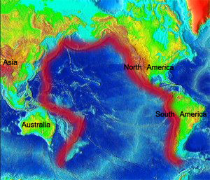
Ring Of Fire: It Is Roaring To Life And There Will Be Earthquakes Of Historic Importance On The West Coast Of The United States

ring of fire
© n/a
Does it seem to you like there has been an unusual amount of seismic activity around the world lately? Well, it isn't just your imagination. The Ring of Fire is roaring to life and that is really bad news for the west coast of the United States.

Approximately 90 percent of all earthquakes and approximately 75 percent of all volcanic eruptions occur along the Ring of Fire.

Considering the fact that the entire west coast of the United States lies along the Ring of Fire, we should be very concerned that the Ring of Fire is becoming more active. On Wednesday, the most powerful strike-slip earthquake ever recorded happened along the Ring of Fire. If that earthquake had happened in a major U.S. city along the west coast, the city would have been entirely destroyed.

Scientists tell us that there is nearly a 100% certainty that the "Big One" will hit California at some point. In recent years we have seen Japan, Chile, Indonesia and New Zealand all get hit by historic earthquakes. It is inevitable that there will be earthquakes of historic importance on the west coast of the United States as well. So far we have been very fortunate, but that good fortune will not last indefinitely.

In a previous article, I showed that earthquakes are becoming more frequent around the globe. In 2001, there were 137 earthquakes of magnitude 6.0 or greater and in 2011 there were 205. The charts and data that I presented in that previous article show a clear upward trend in large global earthquakes over the past decade, and that is why what happened this week is so alarming.


Bizarro Earth

Sumatra Quake 'A Rare Event'

Sumatra Quake
© ReutersResidents sleep on the floor of Baiturrahman Mosque after a powerful 8.6 earthquake and a series of aftershocks hit Banda Aceh, in Indonesia's Aceh province, on Wednesday.
The powerful undersea earthquake off the Indonesian island of Sumatra this week was a one in 2 000 years event, and although it resulted in only a few deaths, it increases the risks of a killer quake in the region.

Wednesday's 8.6-magnitude quake and a powerful aftershock were "strike-slip" quakes and the largest of that type recorded, Kerry Sieh, director of the Earth Observatory of Singapore, said.

"It's an exceptionally large and rare event," he said.

"Besides it being the biggest strike-slip earthquake ever recorded, the aftershock is the second biggest as far as we can tell," Sieh said.

Strike-slip quakes involve the horizontal movement of colliding earth plates, and are less powerful than those where there is vertical movement.