Earthquakes
S

Bizarro Earth

Earthquake Magnitude 5.1 - Off Coast of Oregon

Image
© USGS
Date-TimeTuesday, June 19, 2012 at 13:40:57 UTC
Tuesday, June 19, 2012 at 05:40:57 AM at epicenterTime of Earthquake in other Time Zones

Location
43.431ยฐN, 127.330ยฐW Depth
13.5 km (8.4 miles)

Region
OFF THE COAST OF OREGON

Distances
239 km (148 miles) W of Bandon, Oregon

252 km (156 miles) W of Coos Bay, Oregon

324 km (201 miles) W of Roseburg, Oregon

344 km (213 miles) WNW of Grants Pass, Oregon

Bizarro Earth

Largest earthquake in 109 years rattles Victoria Australia

Image
© Unknown
It hit about 9:00pm (AEST), with the epicentre near Moe in west Gippsland, about 120 kilometres south-east of Melbourne.

Geoscience Australia says the 5.3 quake had a depth of about 10km and rumbled through Melbourne and communities including Bendigo, Ballarat, Geelong and Shepparton.

People have reported hearing a roaring noise, with reports of cracks occurring in the walls and floors of homes.

Victoria Police say they have received a number of calls in relation to the tremor.

They say they have not received any reports of major damage.

The Victorian State Emergency Service (SES) says they have received 40 requests for assistance in the broader Gippsland area and parts of Melbourne, but no reports of significant damage.

The SES's Lachlan Quick says most of the request of assistance have come from areas near the epicentre.

Bizarro Earth

6.4 Magnitude Earthquake Strikes Off The East Coast of Japan

Image
© USGS
A 6.4 magnitude earthquake struck off the coast of Japan early on Monday, the U.S. Geological Survey said. The epicenter was 72 miles southeast of Morioka on Japan's Pacific coast, the USGS said, updating an initial report that said the quake was of magnitude 6.3 and 95 miles off the coast. The depth of the earthquake was 31.8 km (19.8) below the ocean floor. The epicenter of the 6.4 magnitude earthquake was 405 km (252 miles) NNE of Tokyo. No tsunami warnings have been issued and there were no reports of injuries.

Bizarro Earth

USGS: Earthquake Magnitude 6.1 - Luzon, Philippines

Luzon Quake_160612
© USGS
Date-Time
Saturday, June 16, 2012 at 22:18:48 UTC

Sunday, June 17, 2012 at 06:18:48 AM at epicenterTime of Earthquake in other Time Zones

Location
15.574ยฐN, 119.609ยฐE

Depth
35.3 km (21.9 miles)

Region
LUZON, PHILIPPINES

Distances
94 km (58 miles) SW of Dagupan, Luzon, Philippines

109 km (67 miles) NW of Olongapo, Luzon, Philippines

115 km (71 miles) WNW of Angeles, Luzon, Philippines

182 km (113 miles) NW of MANILA, Philippines

Radar

10 Aftershocks Followed 4.0 Earthquake in Orange County, Officials Say

Image
California - The 4.0-magnitute earthquake that rumbled beneath Orange County on Wednesday night resulted in about 10 aftershocks, the most recent occurring Thursday morning, officials said.

The latest temblor, which was too small to feel, happened about 7:30 a.m., about 11 hours after the 4.0-magnitude quake hit, said Bob Dollar, a geophysicist with the U.S. Geological Survey. Most of the aftershocks occurred within about an hour of the 4.0 quake, the largest being two 2.4-magnitude temblors that were about two miles north and north-northwest of Yorba Linda.

The first quake was felt over a wide area of Los Angeles and Orange counties, Dollar said, with more than 8,000 people reporting to the USGS's "Did you feel it?" page.

Radar

Magnitude 5.5 Earthquake Shakes Southeastern Turkey, Some Minor Damage, Injuries Reported


Ankara, Turkey - A moderate earthquake shook southeastern Turkey on Thursday, damaging a mosque's minarets and injuring a handful of people who jumped off buildings in panic, authorities said.

The Kandilli Observatory seismology center said a magnitude 5.5 quake struck at a depth of 5.4 kilometers (3.3 miles) on Thursday morning at 8:52 p.m. ( 0552GMT)

The epicenter of the quake was in the village of Pinaronu in Sirnak province, close to the borders of Syria and Iraq.

Bizarro Earth

Quakes Along Section of San Andreas More Frequent Than Thought

Fault Lines
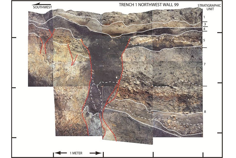
© Modified from Fumal (2012), courtesy of USGS and California Geological SurveyPhoto-mosaic of the northwest wall of a trench across the San Andreas Fault in Mill Canyon near Watsonville, Calif. The photo shows contacts between layers of sediment (white lines) and fault traces (red lines). The dominant, dark gray colored feature is a very large fissure that formed as a result of faulting during an earthquake, most likely in 1838.
Contorted layers of clay and gravel show a segment of the San Andreas Fault that devastated San Francisco with a huge earthquake in 1906 may be more hazardous than previously thought.

The San Andreas Fault divides California for more than 800 miles (1,300 kilometers) from Cape Mendocino to the Salton Sea. The fault marks the boundary between two plates of the Earth's crust: the Pacific Plate on the west side of the fault is sliding slowly northwest past the North American plate on the east.

Geologists Thomas Fumal and Timothy Dawson dug trenches across the San Andreas Fault in the Santa Cruz Mountains, about 5 miles (8 km) northwest of Watsonville and discovered traces of four large past earthquakes. Broken sediment revealed quakes occur more often than prior estimates, and two historic earthquakes reached further south than found before.

Radar

71 confirmed dead in yet another Afghanistan earthquake

Image
A total of 71 people including women and children were killed in the earthquake that hit Burka town in northern Afghanistan on Monday, said Burka district police chief Habib Rahman on Wednesday, citing the latest counting.

"Our counting indicates that 71 people with majority of them women and children have lost their lives in the devastating earthquake that jolted Burka district on Monday," he told newsmen.

Rescue operations have been going on to search the bodies trapped under debris, he added.

A quake measuring 5.7 on the Richter scale shocked several parts of Afghanistan including Kabul and Burka in northern Baghlan province, 160 km north of the capital, on Monday morning.

According to locals, the male members of the affected families in Burka were out on their farmland at the time of the quake and that is why the casualties are mostly women and children.

The earthquake triggered landslides in mountainous Burka district, destroying 25 houses in a village.

Since Burka is a far-flanged area with poor communication facilities, authorities could not report the casualties in time. Meanwhile, some locals believe the casualties may go higher.
Bizarro Earth

4.1 Earthquake Shakes Southern California

LA Quake
© ANSS
A 4.1 earthquake rattled parts of Southern California on Wednesday evening.

The temblor was centered in the Yorba Linda area and occurred at 8:17 p.m. The quake was felt over a wide area of Los Angeles and Orange counties, but there were no immediate reports of damage or injuries.

The quake was centered about two miles north of Yorba Linda and about 28 miles southeast of downtown Los Angeles.

[Updated at 8:35 p.m.: The Orange County Sheriff's Department said there were no immediate reports of damage. Also, a 2.4 magintude aftershock was reported a few minutes after the main quake.]

Bizarro Earth

Sri Lankan geologist says a new tectonic plate being created in the region

Sri Lanka New Tactonic
Colombo: A Sri Lankan geologist says that the new earthquake patterns indicate the creation of a new tectonic plate in the region.

Athula Senaratne, a professor of the Peradeniya University's Geological Research Department has said that the recent quake patterns showed the creation of a new tectonic plate.

He has said that investigations are currently underway to determine the reason for the quakes, felt in some parts of the country on May 26th, had not been recorded in the instruments in Sri Lanka and India.