Earthquakes
S


Bizarro Earth

Tsunamis, earthquakes overdue in Lake Tahoe

Lake Tahoe
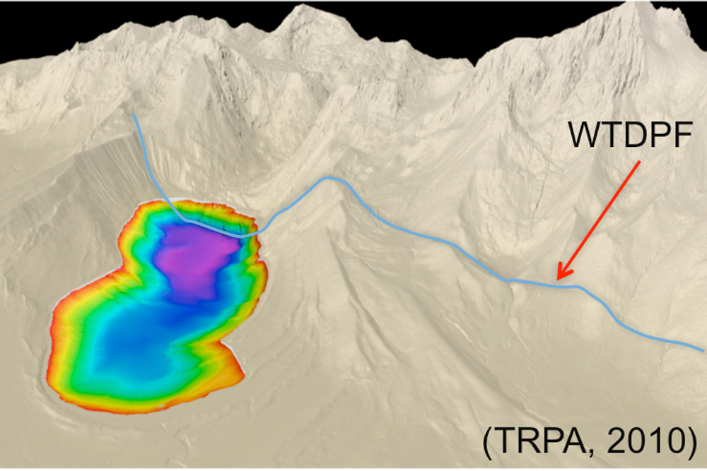
© Jillian Maloney, ScrippsA lidar image of Fallen Leaf Lake in the Lake Tahoe Basin. The blue line is the West Tahoe Fault. The rainbow hues reflect the depth of the lake.
San Francisco - A tsunami-producing fault in Lake Tahoe is overdue for another earthquake, scientists said here yesterday (Dec. 4) at the annual meeting of the American Geophysical Union.

The West Tahoe Fault is capable of producing a magnitude-7.3 earthquake and tsunamis up to 30 feet (10 meters) high in the clear blue lake, where million-dollar homes line the shore, researchers said.

Earthquakes strike every 3,000 to 4,000 years on the fault, and the most recent shaker was 4,500 years ago, indicating the fault is overdue for another earthquake, said Jillian Maloney, a graduate student at the Scripps Institution of Oceanography in San Diego.

The West Tahoe fault defines the west shore of the lake, coming on shore at Baldwin Beach, passing through the southern third of Fallen Leaf Lake, and then descending into Christmas Valley near Echo Summit.
Attention

Eight dead in magnitude 5.5 earthquake in eastern Iran

Image
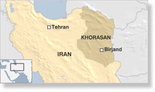
Dubai - An earthquake measuring 5.5 in magnitude struck eastern Iran on Wednesday, killing eight people and injuring 12 others as emergency teams scrambled to rescue others and treat the injured, Iranian media reported.

People fled their homes as the quake struck and brought walls and buildings down. But others were left trapped under rubble in villages across the district of Zohan in South Khorasan province, Fars news agency said.

"Eight people have been killed in the earthquake area and one person is missing. Unfortunately a number of those injured have lost their lives in the last few hours," Mehr news agency quoted South Khorasan's crisis management director Mohammad Ali Akhundi as saying.

"Homes have sustained damage and people are out in public places and they need the means to keep themselves warm because of the cold," he said.

Iran's Red Crescent Society despatched 15 rescue teams to the affected areas to search for people stuck under the debris and doctors in the provincial capital of Birjand were on alert to treat those hurt, Fars new agency reported.

Rescue units of Iran's national Basij militia also joined operations, despatching three medical teams.

Info

Hotspots for huge earthquakes revealed

Earthquake Map
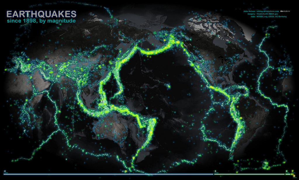
© John Nelson, IDV SolutionsMore than 100 years of earthquakes glow on a world map.
The strongest earthquakes that strike the planet, such as the 9.0-magnitude earthquake that hit Japan last year, occur at particular "hotspot" points of Earth's crust, a new study finds.

About 87 percent of the 15 largest earthquakes in the last century occurred in the intersection between specific areas on spreading ocean plates, called oceanic fracture zones, and subduction zones, where one tectonic plate slides underneath another, according to the paper, published recently in the journal Solid Earth. The scientists used a data mining method to find correlations between locations of earthquakes over the last 100 years, the strength and geological origin.

The bottom of the ocean is crossed by underwater ridges, such as the mid-Atlantic ridge, which runs north to south between the Americas and Africa. These ridges divide two tectonic plates that move apart as lava emerges, solidifying and creating new rock. The midocean ridge jogs back and forth at offsets known as transform faults, creating zigzag-shaped plate boundaries. Fracture zones are scars in the ocean floor left by these transform faults.

Bizarro Earth

USGS: Earthquake Magnitude 5.6 - 42km ESE of Qayen, Iran

Image
© USGS
Event Time
2012-12-05 20:38:12 UTC+03:30 at epicenter

Location
33.520°N 59.570°E depth=5.4km (3.3mi)

Nearby Cities
42km (26mi) ESE of Qayen, Iran
79km (49mi) NNE of Birjand, Iran
123km (76mi) SE of Gonabad, Iran
175km (109mi) SW of Taybad, Iran
503km (313mi) SSE of Ashgabat, Turkmenistan

Bizarro Earth

Seismic swarm of 2000 micro-earthquakes near the island of Nisyros - Eruption imminent?

Image
A seismic swarm of 2000 micro-earthquakes near the island of Nisyros since 24 November could indicate a start of a or coming of a volcanic eruption near Nisyros. The quakes are located between the area of Simi Island (Greece) and the Bozburun peninsula of SW of Turkey. Information is still scanty, but seismic signals from this possible eruption are very similar to those recorded from current volcanic eruptions. If an eruption is taking place, it would form a new submarine volcano near Nisyros. No proof has yet been found to prove that an eruption may be taking place. Some sources think the swarm may be tectonic (as the Aegean sea is very seismically active).

The Volcano Discovery alert will be kept at Green until further evidence is found. The island has a 3 kilometers (1.9 mi) to 4 kilometers (2.5 mi) wide caldera, and was constructed within the past 150,000 years, with 3 separate eruptive stages, ranging from explosive and effusive andesitic eruptions to effusive and extrusive dacitic and rhyolitic activity.

Radar

4.3 magnitude earthquake rattles Slovenia

An earthquake measuring 4.3 on the Richter scale rattled central and eastern Slovenia early on Monday morning. Epicentre of the quake was the village of Gornji Grad, some 30 km north-east of Ljubljana, the local Environmental Agency (ARSO) said.

The quake was powerful enough to be felt across the border in Carinthia according to the Austrian earthquake monitoring organisation which is part of the Austrian Weather Institute (ZAMG).

In a press release ZAMG said the earthquake had been most strongly felt in the Klagenfurt region.

There was no immediate reports of any damage or about anybody injured.

Radar

4.8-Magnitude earthquake shakes Bulgaria's Black Sea coast

An earthquake with a magnitude of 4.8 on the Richter Scale has been registered along Bulgaria's northeast coast in the Black Sea.

The earthquake struck at 8:58 EET, with an epicenter located 21 km east of the town of Kavarna, at a depth of 2 km, the Mediterranean Seismology Center reported, as cited by BTA.

The tremor led the residents of the northeastern Bulgarian town of Shabla to leave their homes but according to Shabla Mayor Rayna Bardareva, there was no panic, as cited by Darik Radio.

Bardareva had no data about injured persons or damages caused by the new tremor.

Monday night's earthquake off the Bulgarian Black Sea coast is the second in the past 24 hours, as a 2.6-magnitude earthquake was registered 45 km southeast of Varna Sunday night.

The newest earthquake near Shabla had roughly the same magnitude as the 4.7-magnitude earthquake that hit the town in the summer of 2009 causing material damages.

Bizarro Earth

Earthquake Magnitude 5.8 rattles Anchorage, Alaska

Image
© USGS
A magnitude 5.8 earthquake struck off the coast of Alaska on Monday, close to the city of Anchorage, rattling buildings and knocking bric-a-brac from shelves, but no serious damage or injuries were reported. The tremor, initially reported as a magnitude 5.7, struck at 4:42 p.m. (8:42 p.m. EST) 25 miles west of Anchorage, the U.S. Geological Survey said. The quake, relatively shallow at a depth of 33.1 miles, was widely felt in Anchorage, according to Guy Urban, a geophysicist for the West Coast and Alaska Tsunami Warning Center in Palmer, Alaska."

Some people in Anchorage said some things fell off the shelves," he told Reuters, adding that the center was unaware of any severe property damage or anyone being hurt. Quakes of similar strength are fairly common in Alaska, one of the most seismically active parts of the United States. - Reuters

Bizarro Earth

Energetic earthquake swarm reported at California's Coso Volcanic Field

Image
An energetic earthquake swarm centered beneath rhyolite domes in the Coso Volcanic Field (CA) continues, with over 20 earthquakes ranging between M1 and M3 so far today. Many smaller events (hundreds) are recorded as well. The swarm initiated on 27 November and has included earthquakes as large as M3.7. The Coso Volcanic Field is located in Inyo County, California, at the western edge of the Basin and Range geologic province and northern region of the Mojave Desert.

The Coso Volcanic Field is one of the most seismically active regions in the United States, producing dozens of tremors in the M1 and M2 range each week. Tremors in the M3 range occur at a rate of 2-6 per month and M4 quakes occur two-three times each year. Recent activity in the M5 range happened in 1996 and 1998 when tremors of M5.3, M5.1, M5.2, and M5.0 occurred with a day of each other.

Blue Planet

November 2012: Super-storms, freak tornadoes, heavy flooding, strong earthquakes and seas turning red

Super-storms, freak tornadoes, heavy flooding, strong earthquakes and seas turning red... another month of earth changes on the Big Blue Marble.