Earthquakes
S


Clock

Canary Islands: New eruption may be brewing at El Hierro volcano

Image
© Unknown
Two years after a new underwater volcano appeared offshore of El Hierro in the Canary Islands, earthquake swarms and a sudden change in height suggest a new eruption is brewing near the island's villages, officials announced today (Dec. 27).

After the announcement, one of the largest temblors ever recorded at the volcanic island, a magnitude-5.1 earthquake, struck offshore of El Hierro at 12:46 p.m. ET (5:46 p.m. local time) today, the National Geographic Institute reported. Residents on the island reported strong shaking, and the quake was felt throughout the Canary Islands, according to news reports. The earthquake's epicenter was 9 miles (15 kilometers) deep.

Before the earthquake struck early this afternoon, the island's volcano monitoring agency, Pelvolca, had raised the volcanic eruption risk for El Hierro to "yellow." This warning means that activity is increasing at the volcano, but no eruption is imminent. A similar burst of activity prompted a yellow warning in June 2012, but the volcano soon quieted down.

Comment: Video of the 2011 underwater volcanic eruption courtesy of ITN:


Bizarro Earth

Earthquakes in Oklahoma: 2 on 29 Dec.

Image
© USGS
The U.S. Geological Survey says a 4.1 magnitude earthquake rattled an area about 30 miles north-northeast of Oklahoma City early Sunday and was followed by a smaller quake hours later in the state. There were no reports of any injuries or damages from either temblor.

Bizarro Earth

USGS: Earthquake Magnitude 5.4 - 31km NW of Frontera Spain

Image
Event Time:
013-12-27 17:46:06 UTC
2013-12-27 17:46:06 UTC+00:00 at epicenter

Location:
27.915°N 18.271°W depth=22.8km (14.2mi)

Nearby Cities:
31km (19mi) NW of Frontera, Spain
89km (55mi) SSW of Los Llanos de Aridane, Spain
98km (61mi) SSW of Santa Cruz de la Palma, Spain
148km (92mi) WSW of Santiago del Teide, Spain
507km (315mi) W of Laayoune / El Aaiun, Western Sahara

Technical Data


Attention

Best of the Web: Signs of Change in December 2013

Image
Rivers turning blood-red, whales beaching themselves in Florida, landslides, sinkholes and flooding in southern Italy, severe flooding in Malaysia, extreme storms bring hurricane-force wind and snow to the UK and northern Europe, ice-storms across the US, including the coldest average day than any day last winter, avalanches of ice falling off buildings as far south as Dallas, the coldest ever recorded temperature anywhere on Earth (in Antarctica), a 'rare winter storm of Biblical proportions' in Palestine, snow in Egypt, fireballs raining down from the sky, including one overhead explosion in Arizona whose shockwave shook buildings from Chandler to Flagstaff, two separate fireballs over Greece, heavy flooding in Rio de Janeiro washing away whole buildings, giant sinkholes swallowing cars and buildings the world over, including one in China that swallowed an entire hamlet of 11 buildings, hundreds of birds falling from the sky in Virginia, the strongest rainfall on record forcing hundreds of thousands of people to evacuate southern China...

The following video is a sample of strange and extreme weather events that took place around the world in first two weeks of December 2013.


Radar

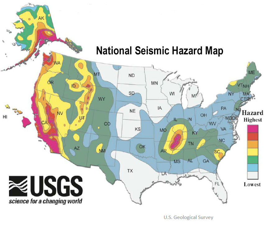
Shake, rattle, and roll: String of earthquakes rumble across U.S.

US seismic hazard map
© U.S. Geological Survey
3.8 magnitude earthquake in Kansas

The Kansas Geological Society is investigating whether a recent earthquake in southern Kansas might have been caused by oil production practices in the area. But KGS interim director Rex Buchanan said it might be difficult to determine if the 3.8 earthquake on Dec. 16 near Caldwell was man-made or caused by natural forces. No evidence has been found yet to suggest hydraulic fracturing caused the quake, said Buchanan. It's more common for minor quakes near oil production sites to be caused by the disposal of salt water waste, The Lawrence Journal-World reported. "There's a lot of saltwater produced with oil," he said. "Once you separate that off, you need to dispose of it. In Kansas, that's done in wells deep in the subsurface. There is production and disposal wells in the general vicinity around there." The Kansas Corporation Commission, which regulates oil and gas production in the state, is also investigating the issue. "It is important to point out that Kansas has a long history of oil production with very few reported incidents of any kind," KCC spokesman Jesse Borjon said in an email to the newspaper. "The KCC is looking into the issue of seismic activity as it relates to oil and gas activities. We have been in communication with the Kansas Geological (Survey) and continue to gather information." It's possible the earthquake was entirely natural, Buchanan said. - LJW

2.3 magnitude earthquake in Ky

Kentucky Emergency Management is reporting that a 2.3 magnitude earthquake was felt near Owingsville around 5:58am Monday. The USGS reports that the disturbance was centered near the Sharpsburg area. Many viewers report feeling the tremors throughout parts of Central Kentucky. Officials report that this type of event is relatively minor. - WKYT

3.3 magnitude earthquake strikes Oklahoma

An earthquake was reported Sunday morning, the U.S. Geological Survey reported. The 3.3 magnitude earthquake shook at about 10:25 a.m. Its epicenter was reportedly 15 miles south of McCord, 17 miles south of Ponca City and 71 miles north of Oklahoma City, the U.S. Geological Survey reported. No damage was immediately reported. - News OK

3.3 magnitude earthquake rattles Texas


Perhaps we should write a story when there's not an earthquake near Azle. For the 14th and 15th time in the last 30 days, people who live northwest of Fort Worth have felt the earth rumble. The latest incident, a 3.3-magnitude quake, was recorded by the U.S. Geological Survey at 7:11 a.m. Monday four miles northwest of Azle just off of S. Reno Rd. There was also an earthquake at 11:31 a.m. Sunday. It also registered as a 3.3-magnitude, according to the USGS. It was centered two miles northwest of Azle, just north of Willow Wood Drive. "Shook my bed and made the walls creak," wrote Azle resident Kim Johnson, who was upstairs in a two-story home. "We now have a few cracks in our vaulted ceilings upstairs. When will it end?" Writing on the WFAA Facebook page, Sandra Tingle said she's worried about liability. "My insurance company told me unless a fault line is determined to be under your property, it's not covered," she said. Sunday's tremor is the fourth-strongest in the past month. The most powerful registered 3.7-magnitude and struck 30 miles west of Azle on December 9. -KHOU

4.7 magnitude earthquake strikes SE California


A shallow magnitude 4.7 earthquake was reported Monday morning 31 miles from Lone Pine, Calif., according to the U.S. Geological Survey. The temblor occurred at 5:39 a.m. PST near the surface. According to the USGS, the epicenter was 41 miles from Ridgecrest, 53 miles from Porterville and 57 miles from Lindsay. In the past 10 days, there have been no earthquakes magnitude 3.0 or greater centered nearby. - LA Times
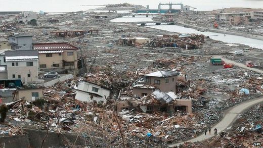
Comment: Things do seem to be ramping up, even in areas considered to be seismically quiet.


Bizarro Earth

Massive 6.2 magnitude earthquake struck Southland, New Zealand

A massive 6.2 magnitude earthquake struck Southland, New Zealand in the early hours of Dec 17. The Southland earthquake was measured 25km deep and centred 125km west of Tuatapere on 1:10 am in the morning.

According to local reports, at least 170 people reported or felt the earthquake with some people coming from further north in Wellington's Naenae. Others reported things falling off their shelves, but aside from that, there was no other damage. A spokesperson for Southland's police department said there were no reports of immediate damage due to the earthquake.

Because of the 6.2 magnitude earthquake, Southland is warned by GNS authorities to expect more tremors. GNS seismologist Caroline Little said the heightened activity in Southland will be associated with the subduction zone as the Australian plate moves under the Pacific plate.

Books

Backdating history to fit present reality: Enormous earthquakes 'are missing' from 19th Century records

Image
British establishment scientists claim that huge earthquakes like the one that struck Japan in 2011 happened just as often in the 19th Century
The Earth could have been struck by many more huge earthquakes in its recent history than was previously thought, scientists say.

Research suggests that half of all quakes measuring more than 8.5 in magnitude that hit in the 19th Century are missing from records.

Scientists are scanning historical documents for the lost tremors.

The findings are presented at the American Geophysical Union Fall meeting in San Francisco.

Dr Susan Hough from the US Geological Survey said: "If you try to make a statistical case there are too few earthquakes in the 19th Century."

Comment: But people were surprised; nobody remembers what happened last month, much less in the 9th and 18th Centuries!

That's because since then and now, things were much calmer. In addition, there's the problem of misinterpreting earthquakes for meteor events, both then and now.

This research is trying to suggest that there is a gradual increase or constant uniformity to the rate of environmental disasters, but the evidence for cyclical catastrophism is writ large in the geological, palaeontological and archaeological records.


Bizarro Earth

USGS: Earthquake Magnitude 6.2 - 195km E of Farallon de Pajaros, Northern Mariana Islands

Mariana Islands Quake_171213
© USGS
Event Time
2013-12-17 23:38:08 UTC
2013-12-18 09:38:08 UTC+10:00 at epicenter

Location
20.764°N 146.760°E depth=16.1km (10.0mi)

Nearby Cities
195km (121mi) E of Farallon de Pajaros, Northern Mariana Islands
623km (387mi) N of Saipan, Northern Mariana Islands
624km (388mi) N of Nth Islands Municipality - Mayor's Office, Northern Mariana Islands
652km (405mi) N of JP Tinian Town pre-WW2, Northern Mariana Islands
824km (512mi) NNE of Yigo Village, Guam

Technical Details

Bizarro Earth

USGS: Earthquake Magnitude 4.2 - 18km WNW of Caldwell, Kansas

Image
© USGS
Event Time:
2013-12-16 15:09:53 UTC
2013-12-16 09:09:53 UTC-06:00 at epicenter

Location:
37.124°N 97.781°W depth=5.0km (3.1mi)

Nearby Cities:
18km (11mi) WNW of Caldwell, Kansas
61km (38mi) SW of Haysville, Kansas
65km (40mi) SW of Derby, Kansas
66km (41mi) W of Arkansas City, Kansas
185km (115mi) N of Oklahoma City, Oklahoma

Technical data

Target

3.1 quake hits in Tennessee near Wildwood Lake

tennessee quake
An earthquake struck today in Tennessee near Wildwood Lake and Cleveland.

The 3.1 magnitude quake hit near the border with Alabama in the Eastern Tennessee Seismic Zone, the U.S. Geological Service said.

Besides being seven miles south-southeast of Wildwood Lake, it was 12 miles south-southeast of Cleveland, and 17 miles north-northeast of Dalton in Georgia.