Earthquakes
S


Bizarro Earth

USGS: Earthquake Magnitude 6.5 - 192km SSE of L'Esperance Rock, New Zealand

L'Esperance Rock Quake_020214
© USGS
Event Time
2014-02-02 09:26:37 UTC
2014-02-01 21:26:37 UTC-12:00 at epicenter

Location
32.908°S 177.822°W depth=40.4km (25.1mi)

Nearby Cities
192km (119mi) SSE of L'Esperance Rock, New Zealand
732km (455mi) NE of Whakatane, New Zealand
740km (460mi) NNE of Gisborne, New Zealand
761km (473mi) NE of Tauranga, New Zealand
1138km (707mi) NE of Wellington, New Zealand

Technical Details

Blue Planet

Disassembling Hawaiian volcanoes - landslides part of the process

hawaiian volcano formation
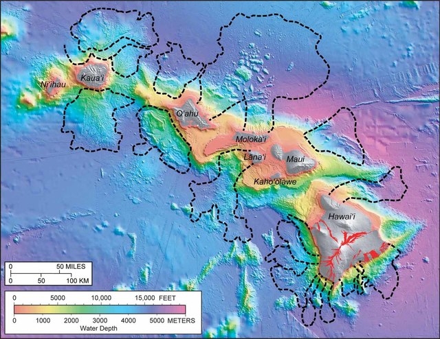
© West Hawaii TodayBlack dashed lines delineate 17 distinct landslides that have occurred around the Hawaiian Islands over the last several million years. The largest slides originated from the north sides of Oahu and Molokai. Colors ranging from pink to purple indicate the water depth around the islands, while shades of gray show land topography above sea level. Red areas on the Island of Hawaii indicate lava flows erupted within the past 200 years.
In our January Volcano Watch articles - Hawaii Island's fifth annual Volcano Awareness Month - we are exploring important questions about how Hawaiian volcanoes work. Last week, we discussed how Hawaiian islands grow; this week, we talk about how they fall apart.

In 1964, irregular submarine topography north of Oahu and Molokai was identified in newly available maps of the sea floor made by the U.S. Navy. James Moore, then Scientist-in-Charge at the USGS Hawaiian Volcano Observatory, suggested that this odd bathymetry might reflect massive landslides originating from those islands.

Moore's interpretation was disputed for more than 20 years until comprehensive mapping of the sea floor around the entire state of Hawaii was completed in the late 1980s. It turned out that Moore was right. Large - even catastrophic - submarine landslide structures litter the sea floor around the Hawaiian Islands. In fact, 17 major landslides have been identified off the shores of the main Hawaiian Islands. Fortunately, these slides are exceedingly rare - occurring, on average, only once every 350,000 years.

The largest landslides constitute significant portions of the islands from which they originated. Imagine if 10 percent of one of the islands suddenly collapsed into the ocean. Such an event would displace a huge amount of water and cause a large tsunami. Deposits of coral and sand have been found approximately 1,000 feet above sea level on several of the Hawaiian Islands. Catastrophic landslides are believed to have generated gigantic tsunami waves that washed ashore and left these deposits behind.

Cow

Ninety flatulent cows start fire at dairy farm in Germany

Image
No more unnatural grains! They make us fart and destroy your buildings!
The methane gas released by 90 flatulent cows caused an explosion in a farm shed in Germany, damaging the roof and injuring one of the animals, local police said.

In a statement, the force said high levels of the methane gas had built up within the structure in the central German town of Rasdorf on Monday thanks to animals belches and flatulence, before "a static electric charge caused the gas to explode with flashes of flames."

The subsequent blast damaged the roof of the cow shed, Reuters reported. Emergency services who attended the scene took gas readings to check for any potential further blasts.

One of the cows was injured and had to be treated for burns it sustained during the incident, a police spokesman added.

The animals can emit up to 500 litres of the greenhouse gas methane each every day through belching and flatulence. Cows also release large amounts of ammonia.

Comment: One of the more serious indirect consequences to humans of their obsession with/addiction to grains and agriculture.


Bizarro Earth

USGS: Earthquake Magnitude 6.1 - 3km S of Lixourion, Greece

Lixourion Quake_270114
© USGS
Event Time
2014-01-26 13:55:42 UTC
2014-01-26 15:55:42 UTC+02:00 at epicenter

Location
38.169°N 20.431°E depth=12.3km (7.7mi)

Nearby Cities
3km (2mi) S of Lixourion, Greece
58km (36mi) NW of Zakynthos, Greece
90km (56mi) WNW of Amalias, Greece
90km (56mi) WSW of Mesolongi, Greece
289km (180mi) W of Athens, Greece

Technical Details

Bizarro Earth

USGS: Earthquake Magnitude 6.1 - 39km SSE of Adipala, Indonesia

Adipala Quake_250114
© USGS
Event Time
2014-01-25 05:14:20 UTC
2014-01-25 12:14:20 UTC+07:00 at epicenter

Location
8.004°S 109.238°E depth=83.2km (51.7mi)

Nearby Cities
39km (24mi) SSE of Adipala, Indonesia
41km (25mi) S of Kroya, Indonesia
53km (33mi) SW of Gombong, Indonesia
54km (34mi) S of Banyumas, Indonesia
330km (205mi) SE of Jakarta, Indonesia

Technical Details

Bizarro Earth

New Madrid fault zone alive and active

Madrid Fault
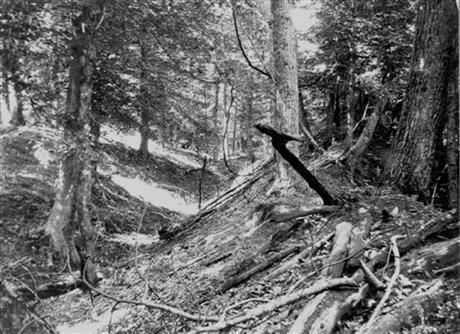
© AP Photo/U.S. Geological Survey,FileThis undated photo provided by the U.S. Geological Survey shows a landslide trench and ridge east of Reelfoot Lake in Obion County, Tenn., made by the New Madrid earthquakes in the early 1800s. U.S. Geological Survey scientists reported Thursday Jan. 23, 2014 that the New Madrid fault zone is still active and could unleash future powerful earthquakes. The zone in the U.S. Midwest produced three strong quakes in 1811 and 1812.
The New Madrid fault zone in the nation's midsection is active and could spawn future large earthquakes, scientists reported Thursday.

It's "not dead yet," said U.S. Geological Survey seismologist Susan Hough, who was part of the study published online by the journal Science.

Researchers have long debated just how much of a hazard New Madrid (MAD'-rihd) poses. The zone stretches 150 miles, crossing parts of Arkansas, Illinois, Indiana, Kentucky, Mississippi, Missouri and Tennessee.

In 1811 and 1812, it unleashed a trio of powerful jolts - measuring magnitudes 7.5 to 7.7 - that rattled the central Mississippi River valley. Chimneys fell and boats capsized. Farmland sank and turned into swamps. The death toll is unknown, but experts don't believe there were mass casualties because the region was sparsely populated then.

Bizarro Earth

5.1-magnitude quake hits northeast Jazan, Saudi Arabia

Image
© USGS
An earthquake measuring 5.1 on the Richter scale has hit the northeastern region of Jazan. Its impact was felt by inhabitants in the Asir and Najran regions, according to postings on social networking sites. ani Zahran, director-general of the National Center for Earthquakes and Volcanoes, told Arab News: "The earthquake occurred at around 6 p.m. local time. It measured 5.1 on the Richter scale and was 10 km deep."

Citizens in both the Jazan and Asir provinces confirmed that they felt the earthquake's impact at 6 p.m.
Many said that their doors and windows rattled as a result of the tremor, according to local media sources. A security source said that the Civil Defense operations room in Jazan received dozens of calls from citizens when the earthquake struck across the Jazan province.

USGS data

Info

Mini-earthquakes continue in north Texas, local residents blame it on fracking

Image
Dozens of Azle residents are planning a trip to the state capitol to send a message to the Texas Railroad Commission.

Organizers have named the bus trip "Shake the Ground in Austin," and they expect at least 50 people to show up for the regularly scheduled Texas Railroad Commission meeting Tuesday morning.

Some Azle residents believe there is a link between local fracking injection wells and a series of recent earthquakes. In a one-month span, about 30 minor earthquakes hit the area.

The Texas Railroad Commission regulates oil and gas operations. Earlier this month, more than 800 Parker County residents attended a meeting hosted by TRC Commissioner David Porter at Azle High School and pressed him for answers about the earthquakes. However, some residents left the meeting more angry and frustrated than when it began.

"We need to get some relief for people who are having their homes damaged by these earthquakes," said Sharon Wilson, Texas organizer for Earthworks Oil & Gas Accountability Project.

Attention

6.2-magnitude earthquake hits lower North Island, New Zealand

Image
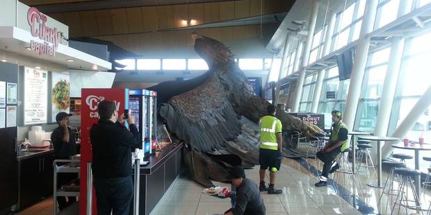
© Kylie Te MoanauiThe giant eagle hanging from the roof of Wellington airport to promote the Hobbit trilogy has fallen down due to the shake.
A "severe'' magnitude 6.2 quake has damaged homes and closed roads in the lower North Island, toppling walls and chimneys and sending rockfalls across roads.

The quake, initially reported as a magnitude 6.3, struck 10km north of Castlepoint in Wairarapa, at a depth of 33km, at 3.52pm, GeoNet said.

Sara Page, GeoNet public information specialist at GNS Science, said GeoNet had received more than 6000 "felt" reports from the public by 4.30pm, with some reporting damage.

"As expected after a quake of this size, there have been multiple aftershocks, and these will continue for some time as the region settles," she said.

The Wairarapa is no stranger to large earthquakes, with two very damaging magnitude 7 quakes in 1942.

However, the region's last earthquake above magnitude 6 was in 1961.

Damage reports

Fifteen people will not be able to return home tonight after their building in the centre of Masterton was red-stickered as a result of today's earthquake.

Wairarapa area Civil Defence controller Kevin Tunnell said the three-storey Daniels Building on Queen St had sustained unspecified damage in the quake.

It was initially deemed unsafe by the Fire Service and then by Masterton District Council engineers.

Its 15 tenants would not be allowed home for at least tonight and engineers would carry out further inspections tomorrow.
Bizarro Earth

USGS: Earthquake Magnitude 6.3 - 38km NNE of Masterton, New Zealand

Masterton Quake200114
© USGS
Event Time
2014-01-20 02:52:44 UTC
2014-01-20 15:52:44 UTC+13:00 at epicenter

Location
40.650°S 175.864°E depth=27.4km (17.0mi)

Nearby Cities
38km (24mi) NNE of Masterton, New Zealand
39km (24mi) SSE of Palmerston North, New Zealand
49km (30mi) E of Levin, New Zealand
77km (48mi) ENE of Paraparaumu, New Zealand
115km (71mi) NE of Wellington, New Zealand

Technical Details