Earthquakes
S


Bizarro Earth

USGS: Earthquake Magnitude 6.7 - Santiago Del Estero, Argentina

Argentina Quake 280512
© USGS
Date-Time
Monday, May 28, 2012 at 05:07:23 UTC

Monday, May 28, 2012 at 02:07:23 AM at epicenterTime of Earthquake in other Time Zones

Location

28.060°S, 63.109°W

Depth

589.3 km (366.2 miles)

Region
SANTIAGO DEL ESTERO, ARGENTINA

Distances
52 km (32 miles) NNW of Anatuya, Santiago del Estero, Argentina

117 km (72 miles) ESE of Santiago del Estero, Argentina

249 km (154 miles) SE of San Miguel de Tucuman, Tuc., Argentina

838 km (520 miles) NNW of BUENOS AIRES, D.F., Argentina

Bell

Fourth earthquake rocks East Texas

The fourth earthquake in 16 days hit East Texas early Saturday.

No injuries or significant damage were reported from the preliminary magnitude 2.5 temblor that hit about 1:30 a.m., said Larry Burns, emergency management coordinator in Timpson.

The quake was centered about seven miles southeast of town, near FM 1645 and Texas 87, according to information from the U.S. Geological Survey.

"One of the guys I work with, he told me it shook but it wasn't like any of the others we've had," said Burns, who was not in town when the latest quake occurred. "We're up to four of them so far."

There perhaps have been more than that, according to accounts collected by the Timpson and Teneha News, Mayor Debra Smith said Saturday.

"I think they've determined we are up to seven in the last 12 months," the mayor said, dating the first reports to July. "But some of them were smaller than the (Geological Survey) keeps up."

Bizarro Earth

USGS: Earthquake Magnitude 6.0 - Bonin Islands, Japan Region

Japan Quake_260512
© USGS
Date-Time
Saturday, May 26, 2012 at 21:48:09 UTC

Sunday, May 27, 2012 at 07:48:09 AM at epicenterTime of Earthquake in other Time Zones

Location

26.876°N, 140.214°E

Depth

472.6 km (293.7 miles)

Region
BONIN ISLANDS, JAPAN REGION

Distances
201 km (124 miles) W of Chichi-shima, Bonin Islands, Japan

255 km (158 miles) NNW of Iwo Jima, Volcano Islands, Japan

694 km (431 miles) S of Hachijo-jima, Izu Islands, Japan

979 km (608 miles) S of TOKYO, Japan

Bizarro Earth

5.6 earthquake which jolted Bulgaria was strongest since 1858, and the aftershocks continue

The earthquake that the Bulgarian capital Sofia experienced at 3 am on Tuesday has been the strongest in its history since 1858, i.e. in 154 years, historical records indicate.
Image
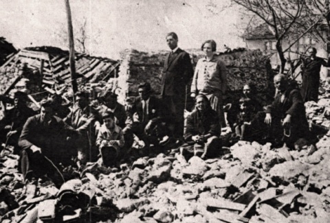
© Lost BulgariaA file photo shows destruction from the 1928 earthquake in Chirpan; the small Bulgarian town was hit by another quake in 1942.
On Tuesday, Bulgaria's territory saw over 60 weak aftershocks after the 5.8-5.9-magnitude it experienced early Tuesday morning, according to the Geophysics Institute of the Bulgarian Academy of Sciences.

All of the 60 aftershocks had magnitudes of over 1 on the Richter scale, and their epicenters were around the western Bulgarian city of Pernik, where the initial earthquake hit at about 2:58 am on Tuesday. Some of the major aftershocks had a magnitude of 4.2-4.7, and were felt in Pernik and Sofia.

On September 30, 1858, when the future Bulgarian capital was still only a provincial town in the Ottoman Empire, it suffered an earthquake that had an estimated magnitude of 6.6-7.0 on the Richter Scale, damaging some 80% of its buildings.

Bizarro Earth

Earthquake Magnitude 4.8 shakes nervous Christchurch, sending shoppers fleeing into the streets

Image
© Unknown
Nervous shoppers fled into the streets when a 4.7-magnitude earthquake rattled the New Zealand city of Christchurch, halting rebuilding work following last year's tremor that killed 185.

These were no immediate reports of damage or injuries and police and ambulance services said they had received no calls for assistance.

The quake struck at 12.44pm (AEST) at a shallow depth of eight kilometres about 25 kilometres east of New Zealand's second largest city, the US Geological Survey said.

The Canterbury Earthquake Recovery Authority, which is overseeing reconstruction after the deadly 6.3 tremor in February last year, said it suspended demolition work in the city centre as a precaution.

Christchurch has experienced thousands of aftershocks in the past 18 months, delaying efforts to rebuild and further unsettling residents.

Bizarro Earth

USGS: Earthquake Magnitude 6.2 - Norwegian Sea

Norwegian Quake_240512
© USGSEarthquake Location
Date-Time
Thursday, May 24, 2012 at 22:47:46 UTC

Thursday, May 24, 2012 at 10:47:46 PM at epicenterTime of Earthquake in other Time Zones

Location

72.994°N, 5.651°E

Depth
8.8 km (5.5 miles)

Region
NORWEGIAN SEA

Distances
601 km (373 miles) NW of Tromso, Norway

676 km (420 miles) WNW of Hammerfest, Norway

716 km (444 miles) NNW of Bodo, Norway

1472 km (914 miles) NE of REYKJAVIK, Iceland

Cloud Lightning

Hurricane Bud could bring life-threatening conditions to Mexico

Image
© UnknownHurricane Bud is expected to approach the Mexico coast late Friday evening.
Hurricane Bud quickly strengthened early Thursday after forming off the southwestern coast of Mexico just hours before, the National Hurricane Center in Miami reported.

The Category 1 storm with 90 mph winds was about 350 miles (560 kilometers) southwest of Manzanillo, and was tracking to the north at 7 mph.

Some additional strengthening is expected Thursday, the hurricane center said. "Gradual weakening is expected to begin by Friday."

The forecast map shows the storm approaching the coast late Friday before slipping off to the southwest and away from land.

Bud is the second named tropical storm of the East Pacific hurricane season.

Radar

Earthquake hits cheese production in northern Italy

Image
© AP Photo/Luca BrunoOriano Caretti looks at the overturned shelves with Parmesan wheels in his Parmesan cheese factory in San Giovanni in Persiceto, Italy, Monday, May 21, 2012. A magnitude-6.0 earthquake shook northern Italy early Sunday, killing at least three people and toppling some buildings, emergency services and news reports said. The quake struck at 4:04 a.m. Sunday between Modena and Mantova, about 35 kilometers (22 miles) north-northwest of Bologna at a relatively shallow depth of 10 kilometers (6 miles), the U.S. Geological Survey said.
The earthquake that struck northern Italy will affect production and export of some of the area's most internationally famous culinary delicacies - Parmigiano Reggiano and Grana Padano cheeses.

National farmers' group Coldiretti has estimated damage to agriculture in the area, one of Italy's most fertile and productive zones, at more than 200 million euros.

Some of the worst damage was to the production of Parmigiano Reggiano, also called Parmesan cheese, and its eternal rival, Grana Padano.

Both of the very hard seasoned cheeses are grated over pasta dishes, thinly sliced on salads or served in small, irregular pieces at fashionable parties worldwide.

Their respective passionate devotees can be compared to fans supporting different sports teams in the same town.
Radar

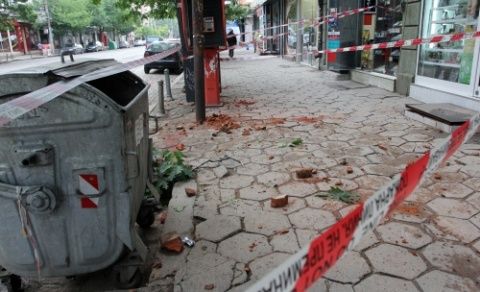
Magnitude 5.8 Bulgarian Earthquake Followed By 80 Aftershocks, Worst in Region Since 1917

Image
© BGNES A 5.7-5.9 magnitude earthquake struck southwest of Bulgaria's capital Sofia shortly after 3:00 am on Tuesday.
An earthquake of a magnitude of 5.7 to 5.9 struck the Bulgarian city of Pernik, 25 kilometers (15.5 miles) northwest of the capital Sofia.

The quake, the worst in the Sofia area since 1917, shook the country at 2:58 a.m. local time, causing walls and roofs to collapse in Pernik and chimneys and plaster to fall in Sofia, Interior Minister Tsvetan Tsvetanov said on the ministry's website today. There were no casualties, Prime Minister Boiko Borissov said in an interview with Nova Television station.

The capital city's airport, railways and subway are working and no damage to infrastructure in the country has been reported, Construction Minister Liliana Pavlova told reporters in Sofia. In Pernik, which was worst affected by the quake, the heating utility was shut down and schools were closed for today and tomorrow.

Bizarro Earth

USGS: Earthquake Magnitude 6.1 (Magnitude Changed to 6.0) - Hokkaido, Japan

Image
© USGS
Date-Time
Wednesday, May 23, 2012 at 15:02:25 UTC
Thursday, May 24, 2012 at 12:02:25 AM at epicenterTime of Earthquake in other Time ZonesLocation
41.378°N, 142.073°E

Depth
40.7 km (25.3 miles)

Region
HOKKAIDO, JAPAN REGION

Distances
107 km (66 miles) NNE of Hachinohe, Honshu, Japan
119 km (73 miles) ESE of Hakodate, Hokkaido, Japan
127 km (78 miles) ENE of Aomori, Honshu, Japan
663 km (411 miles) NNE of TOKYO, Japan