Earth ChangesS


Cloud Lightning

US, Indiana: Storm Causing Flood Delays Second Half of Notre Dame Game

Notre Dame Stadium
© unknownNotre Dame Stadium
Notre Dame and South Florida returned to the field Saturday after a halftime delay of more than two hours caused by storms that prompted officials to ask fans to evacuate Notre Dame Stadium.

After two storms passed, but with lightning strikes still visible away from the stadium, the teams came back on the field for a 12 1-2 minute warmup period before resuming play. The total delay was 2 hours, 10 minutes. South Florida led 16-0 against a sloppy Irish team that was hurt by turnovers.

Notre Dame made one big change during the long delay. They replaced struggling starting quarterback Dayne Crist with Tommy Rees. Crist, starting for the first time since he suffered the second knee injury of his career last Oct. 30, was just 7-for-15 for 85 yards with an interception in the first half.

Bizarro Earth

Vanuatu - Earthquake Magnitude 7.0

Vanuatu Quake_030911
© USGSEarthquake Location
Date-Time:
Saturday, September 03, 2011 at 22:55:36 UTC

Sunday, September 04, 2011 at 09:55:36 AM at epicenter

Time of Earthquake in other Time Zones

Location:
20.585°S, 169.696°E

Depth:
132.4 km (82.3 miles)

Region:
VANUATU

Distances:
122 km (75 miles) SSE of Isangel, Tanna, Vanuatu

217 km (134 miles) ENE of Tadine, Loyalty Islands, New Caledonia

347 km (215 miles) SSE of PORT-VILA, Efate, Vanuatu

1860 km (1155 miles) ENE of BRISBANE, Queensland, Australia

Snowman

Best of the Web: Early Winter Snowfall Predicted For Ireland and UK

UK under snow
© MODISIreland and UK from space on Christmas Day 2010.
A long range weather forecaster is predicting an early start to winter 2011-2012 for many regions of the United Kingdom and Ireland. James Madden of Exacta Weather says heavy snowfalls are likely in places as soon as late October and early November.

Last week, UK-based Positive Weather Solutions also predicted that the winter months will be colder than average everywhere and that some regions will experience significantly colder than average temperatures between December and March.

Bizarro Earth

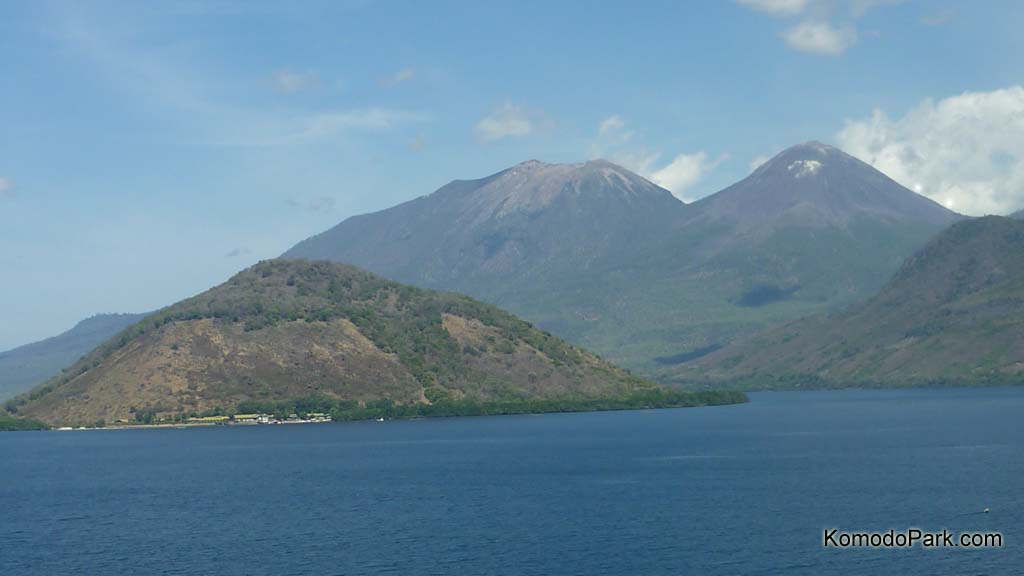
Indonesia: Increased Activity at 22 Volcanoes, Alert Raised

Twin Peaks
© Komodo Park.comTwin volcanoes in Flores Island, Indonesia.
The government has requested that local administrations remain on the alert for severe risks of volcanic eruptions, as the number of volcanoes showing abnormal activity continued to raise.

As of Friday, activity in 22 volcanoes was categorized as above normal, with six at alert level three and 16 at level two. Volcano status ranges from level one, which is normal, to four, which is the highest alert.

The Volcanology and Geophysical Disaster Mitigation Center (PVMBG) raised the status of Papandayan, one of the major tourist destinations in Garut, West Java, to alert level three on Friday.

"There were 48 shallow volcanic earthquakes detected, with one deep volcanic earthquake and a white cloud emitted as high as 20 meters on Thursday," National Disaster Management Agency (BNPB) spokesman Sutopo Purwo Nugroho said.

Sutopo added that his office had prepared contingency plans to anticipate worst-case scenarios if
Papandayan erupts.

"If Papandayan erupts, it would impact 171,744 people living in the five subdistricts and 20 villages," he said.

Indonesia has been dubbed the world's most disaster-prone country for its frequent earthquakes, volcanic eruptions, tsunamis, floods and droughts.

Bizarro Earth

Tropical Storm Lee Begins Pelting Gulf Coast

Image
© AP Photo/Gerald HerbertA hotel is reflected in puddles of rain from approaching Tropical Storm Lee at a streetcar track, as a streetcar passes through Lee Circle, in New Orleans, Friday, Sept. 2, 2011.
Heavy rains from Tropical Storm Lee were falling in southern Louisiana and pelting the Gulf Coast on Saturday as the storm's center trudged slowly toward land, where businesses were already beginning to suffer on what would normally be a bustling holiday weekend. The storm could drop as much as 20 inches of rain in some areas.

Tropical storm warning flags were flying from Mississippi to Texas and flash flood warnings extended along the Alabama coast into the Florida Panhandle. The storm's slow forward movement means that its rain clouds should have more time to disgorge themselves on any cities in their path.

The National Hurricane Center said the center of Lee was about 45 miles (72 km) south of New Iberia and moving north-northwest at 7 mph (11 kph). It was expected to cross the Louisiana coast Saturday and meander through the state's southern parishes through Sunday.

Forecasters at the National Hurricane Center say that Lee's maximum sustained winds had increased to 60 miles per hour (95 kph) Saturday morning.

Bizarro Earth

South Sandwich Islands - Earthquake Magnitude 6.2

S.Sandwich Islands Quake_030911
© USGSEarthquake Location
Date-Time:
Saturday, September 03, 2011 at 04:49:00 UTC

Saturday, September 03, 2011 at 02:49:00 AM at epicenter

Time of Earthquake in other Time Zones

Location:
56.551°S, 27.039°W

Depth:
106 km (65.9 miles)

Region:
SOUTH SANDWICH ISLANDS REGION

Distances:
19 km (11 miles) NNE of Visokoi Island, South Sandwich Islands

278 km (172 miles) N of Bristol Island, South Sandwich Islands

2065 km (1283 miles) ESE of STANLEY, Falkland Islands

3416 km (2122 miles) SE of BUENOS AIRES, D.F., Argentina

Info

US: IFAW Rescues and Releases a Record 11 Stranded Dolphins

Stranded Dolphins
© IFAW
Yarmouth Port, MA - As the afternoon tide was going out on the last day of August; 13 common dolphins headed toward the shoreline off First Encounter Beach in Eastham, MA. Rescuers from the International Fund for Animal Welfare (IFAW) responded quickly - rescuing 11 healthy animals from certain death.

First, the team tried to herd the animals back out to open water by dropping acoustic deterrents called pingers from a boat, but unfortunately this technique was unsuccessful and the pod of dolphins beached themselves despite their efforts.

"Our goal was to get the healthy animals back out to open water as soon as possible," said Katie Moore, IFAW's Marine Mammal Rescue team Manager. "Two of the animals died almost immediately after stranding, but fortunately we were able to transport 11 remaining dolphins to Herring Cove Beach in Provincetown and release them to the safety of open water. This is the largest number of dolphins we have ever rescued and released at one time."

Bizarro Earth

Big Earthquake Strikes Alaskan Islands, Triggers Tsunami Warning

Tsunami Warning
© OurAmazingPlanet
A magnitude 6.8 earthquake struck Alaska's Aleutian Islands in the wee hours of the morning today (Sept. 2), prompting a tsunami warning in the Pacific Ocean that was then canceled about an hour later.

The earthquake, originally reported to be a 7.1 magnitude, was later revised down by the U.S. Geological Survey. It occurred in the Fox Islands, about 1,030 miles (1,658 kilometers) from Anchorage at 6:55 a.m. EDT (1:55 a.m. local time).

The rupture occurred about 22 miles (35 km) below the Earth's surface. The Aleutian Islands are no strangers to the Earth's rumblings, as they are part of the seismically and volcanically active Pacific Ring of Fire.

The tsunami warning was issued initially, but no tsunami waves were recorded and the warning was rescinded.

The island chain's Cleveland Volcano has recently been stirring, growing a new lava dome atop its peak.

Bizarro Earth

Fox and Aleutian Islands, Alaska - Earthquake Magnitude 6.8

Alaska Quake_020911
© USGSEarthquake Location
Date-Time:
Friday, September 02, 2011 at 10:55:54 UTC

Friday, September 02, 2011 at 01:55:54 AM at epicenter

Time of Earthquake in other Time Zones

Location:
52.185°N, 171.684°W

Depth:
35.5 km (22.1 miles)

Region:
FOX ISLANDS, ALEUTIAN ISLANDS, ALASKA

Distances:
45 km (27 miles) SW of Amukta Island, Alaska

85 km (52 miles) SW of Yunaska Island, Alaska

1658 km (1030 miles) WSW of Anchorage, Alaska

2410 km (1497 miles) W of WHITEHORSE, Yukon Territory, Canada

X

California, US: Sea lion bites caused mysterious pelican wounds, biologists find

Image
© Unknown
Underwater attacks by biting sea lions are responsible for injuring or killing nearly a dozen brown pelicans off the Central Coast of California since last week, state wildlife officials said Wednesday.

Until now it had been a mystery what was causing the seabirds to appear along the coast near San Luis Obispo with gaping puncture wounds to the chest.

California Department of Fish and Game biologists took several of the dead pelicans to a laboratory in Santa Cruz to undergo necropsies. The examinations showed their wounds were caused by sea lion teeth.