Earth ChangesS

Attention

Flashback La Nina Causing Global Mayhem

Deadly heat bakes the Midwest and East Coast, floods leave millions homeless in Asia, and a tinder-dry Los Angeles city waits for wildfires.

All of this global weather mayhem and more comes courtesy of La Nina.

A cooling of the ocean surface off the western coast of South America, occurring periodically every 4 to 12 years and affecting Pacific and other weather patterns, which forecasters said Thursday is certain to rebound this winter after showing hopeful signs of weakening during the spring.

For Southern California and the world, that means another year of climate chaos, including a second dry and dangerous fire season for Los Angeles and a host of hurricanes to batter the Atlantic coast.

Bizarro Earth

Flashback La Nina threatens to wreck world's weather

Experts predict a run of severe weather in the coming months, with devastating floods striking some parts of the world while severe droughts afflict other regions, as the climate phenomenon known as La Niรฑa gathers momentum.

A chronic drought afflicting southern California and many southeastern states of America could be exacerbated, with Los Angeles heading for its driest year on record. In contrast, western Canada and the northwestern US could turn colder and snowier. Mozambique, southeast Africa, and northern Brazil may face exceptionally heavy rains and floods, while southern Brazil and much of Argentina suffer drought.

Phoenix

World Crops Threatened by Strengthening La Nina Weather Pattern

Grain and oilseed crops may be threatened next year by a weather pattern known as La Nina, according to a private forecaster.

La Nina conditions have developed rapidly across the equatorial Pacific Ocean during the past few weeks, said Drew Lerner, president of World Weather Inc. in Overland Park, Kansas. He said that may indicate more dry weather in parts of South America in the next three months and a wet, cold start to the U.S. planting season in March.

La Nina, which means "the little girl" in Spanish, is caused by lower-than-normal surface-water temperatures in the Pacific. It can trigger widespread changes in weather around the world, including a higher-than-normal number of hurricanes in the Atlantic Ocean, Lerner said.

Wolf

India: Thousands trapped in -15 degree snowstorm in Sikkim

A trip to the snow-laden Changu Lake turned into a nightmare for more than 3, 500 tourists including hundreds of children on Friday. They were trapped in snowstorm conditions with the temperature dipping to minus 15 degrees at a killing altitude of 13,300 feet before the army pulled them to safety.

The majority of those trapped were from Bengal. Hundreds fell ill, shivering in the icy cold as their vehicles remained stranded near Changu and Baba Mandir for hours. Clad in just jackets and scarves, the holidayers were hardly prepared, mentally or physically, to encounter a blizzard.

The army rescued them and took them to military camps, where warm soup and loads of blankets helped revive most of them. Many had to be admitted to the army medical units for treatment.

Bulb

For the First Time in Years, Western Part of Lake Superior Freezes Over

If the big lake seems to have an unusually placid appearance off Duluth's shores these days, it's because you're looking at ice. Ice has formed on Lake Superior off the Twin Ports and near Bayfield, among other places. It is the first time in years that ice has formed on the lake this early in the winter season. The western tip of Lake Superior has frozen over in December for the first time in recent memory, and that could mean a long season of ice angling that hasn't been seen in years.

"We were just talking that it's been something like 17 years since we had a good, long ice fishing season at this corner of Lake Superior," said Russ Francisco, owner of Marine General sporting go ods store in Duluth. "This is the most ice I've seen in December in years. I wouldn't go out yet, but if it stays cold and we don't get a big wind, people will be out there fishing soon."

Igloo

Down to -13C! New Year temperatures set to plummet as Siberian blast grips the UK

Bitter winds, freezing fog and icy nights will usher in the New Year, forecasters have warned.

Temperatures could drop to as low as minus 13c (9f) in the next couple of weeks as Britain experiences night after night of frost.

Daytime temperatures will barely rise above zero in many areas this week, and revellers will need to wrap up warmly on New Year's Eve to keep out the chill.
Inverness chill
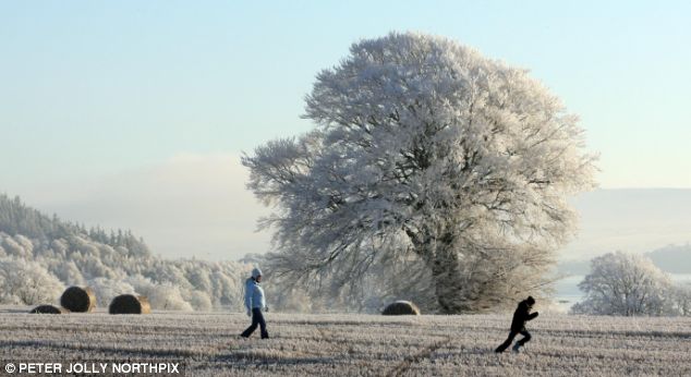
© Petter Jolly NorthpixWalkers near Inverness pass in front of a tree decked out in white from the frost. Below, geese take off from the same frozen landscape

The forecast follows the coldest start to winter in three decades and a blast of snowy weather which hit Britain in early December.

Met Office forecaster Stephen Holman said the next two weeks are expected to remain bitterly cold.

There is significant risk of a 'very cold snap' towards the end of the next fortnight bringing sleet and snow in northern and eastern regions, he added.

Comment: The article ends with the usual lies to make this seem normal and consistent with the global warming hoax.

During the winter months in the northern hemisphere low pressure tends to dominate over Iceland and high pressure to the south, over the Azores. The two pressure systems work together fluctuating and generally are the forces responsible for the winter weather. This is known as the North Atlantic Oscillation (NAO). When the Icelandic low pressure system and Azores high pressure system are strong, they generate wet and mild weather over Europe. But when the NAO goes into a negative phase it drives the bitterly cold arctic air into the UK and Europe. The NAO is turning negative right now.

The image below shows the relationship of the Atlantic Oscillation (AO) and North Atlantic Oscillation (NAO) in both positive and negative cycles.
North Atlantic Oscillation
© unknownNorth Atlantic Oscillation

It appears that not only is the NAO going negative but possibly also the Atlantic Oscillation may follow closely behind. If the AO goes strongly negative a strengthening arctic blast will move down over North America within a week or two of Europe going into the deep freeze. If this does come about, January will see the entire northern hemisphere under arctic influences.


Bell

The Aegean is rocking like a cradle

A 5.2 earthquake has occurred in the Aegean Sea.

According to information received from the Bosphorus University Kandilli Meteorology and Earthquake Institution, at 00:58 a 5.2 earthquake was centered in the Aegean Sea.The earthquake was qualified as intensive.

Following the 5.2 earthquake, which took place at 00:58, 18 other aftershocks were experienced in the same region ranging from 2.6 to 3.5 in strength.

Cloud Lightning

Lightning hits Hawaiian Air jet; none injured

Lightning struck a Hawaiian Airlines plane flying from Honolulu to Hilo on Friday.

Hawaiian spokesman Keoni Wagner says no one was injured but the lightning caused some superficial damage to the plane.

Wagner says about 100 passengers were on board Flight 102 when the bolt hit. The plane landed at 6:28 a.m., about 15 minutes late.

Target

Moderate earthquake hits China

A 5.0-magnitude earthquake struck southwest China on Monday, shaking a wide area that was heavily damaged in this year's Sichuan disaster, officials and residents said.

The quake hit a remote, mountainous part of the province at 2:18pm (0618 GMT) about 100 kilometres (60 miles) north of Mianyang, a city in one of the zones worst affected by the May earthquake, the US Geological Survey said.

There were no immediate reports of deaths, injuries or damage, an official at the Sichuan Seismological Bureau, who would only give his surname as Chen, told AFP.

Cloud Lightning

US: Winds cut power to 370,000 in Michigan; floods threaten

Image
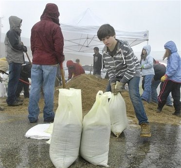
© AP Photo/The Daily Herald, Laura StoeckerAdam Koehl, 11, of Boy Scout Troop 56, moves a sandbag while he and other scouts from various troops help fill some 2,400 sandbags at the Campton Township Highway Department in Lily Lake, Ill., west of Chicago, for use by anyone trying to stem local flooding Saturday morning, Dec. 27, 2008.
Detroit - Wind gusting more than 60 mph knocked out power to about 370,000 Michigan homes and businesses on Sunday as temperatures dipped back into the 20s and 30s.

Meanwhile, flood warnings were posted throughout the Midwest as temperatures rose after a week of heavy snowfall. Forecasters said flooding was possible in areas of Wisconsin, Ohio, Iowa, Michigan and Indiana.

In Michigan, high wind knocked down tree limbs and power lines. Parts of the state also got about 4 inches of snow.

"We've had an intensifying storm system track northeast through the state," said Mark Sekelsky, a meteorologist with the National Weather Service in Grand Rapids. "As that storm intensified, it brought the winds."