Earth ChangesS


Nuke

US: Flood Berm Collapses at Nebraska Nuclear Plant

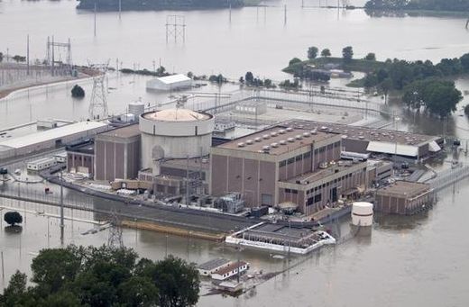
The Fort Calhoun nuclear power station in Fort Calhoun, Neb.
© AP Photo/Nati HarnikThe Fort Calhoun nuclear power station in Fort Calhoun, Neb., currently shut down for refueling, is surrounded by flood waters from the Missouri River, Tuesday, June 14, 2011. On Tuesday, the releases at Gavins Point Dam in South Dakota hit the maximum planned amount of 150,000 cubic feet of water per second, which are expected to raise the Missouri River 5 to 7 feet above flood stage in most of Nebraska and Iowa.
A berm holding the flooded Missouri River back from a Nebraska nuclear power station collapsed early Sunday, but federal regulators said they were monitoring the situation and there was no danger.

The Fort Calhoun Nuclear Station shut down in early April for refueling, and there is no water inside the plant, the U.S. Nuclear Regulatory Commission said. Also, the river is not expected to rise higher than the level the plant was designed to handle. NRC spokesman Victor Dricks said the plant remains safe.

The federal commission had inspectors at the plant 20 miles north of Omaha when the 2,000-foot berm collapsed about 1:30 a.m. Sunday. Water surrounded the auxiliary and containment buildings at the plant, it said in a statement.

The Omaha Public Power District has said the complex will not be reactivated until the flooding subsides. Its spokesman, Jeff Hanson, said the berm wasn't critical to protecting the plant but a crew will look at whether it can be patched.
Bizarro Earth

Costa Rica's Turrialba Volcano More Active Experts Notice

The Turrialba volcano has been more active in recent days, spewing out greater emission of gases and with sound that appears similar to a jet engine.

"The gas column is more abundant, the noise is more noticeable in parts that were it is not usual", said Eliecer Duarte, volcanologist for the OVSICORI.

Turrialba Volcano
© InsideCostaRica
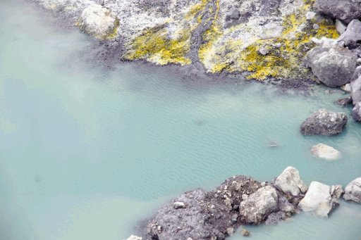
Duarte and other specialists visited the colossus on Thursday and found that the lake that formed in the western crater "blocked" the escape of gas which means they now soar over the entire crater.

"It is a process we have not seen before. The gases are distributed by sector but now gas is emanating 360-degrees around the crater", said Duarte.

Cloud Lightning

How Strong Can a Hurricane Get?

Image
© Unknown
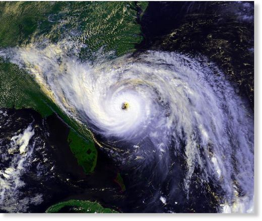
Category 5 on the Saffir-Simpson hurricane scale has no upper bound, on paper. But in theory, winds from a powerful hurricane could blow the scale out of the water, scientists say. There is no such thing as a Category 6 storm, in part because once winds reach Category 5 status, it doesn't matter what you call it, it's really, really bad.

The scale starts with a Category 1, which ranges from 74 to 95 mph. A Category 5 storm has winds of 156 mph or stronger. An extrapolation of the scale suggests that if a Category 6 were created, it would be in the range of 176-196 mph.

Hurricane Wilma, in 2005, had top winds of 175 mph.

Bizarro Earth

Iran: Earthquake Magnitude 5.1 - Eastern Iran

Image
© USGS
Date-Time:
Sunday, June 26, 2011 at 19:47:01 UTC

Sunday, June 26, 2011 at 11:17:01 PM at epicenter

Time of Earthquake in other Time Zones

Location:
30.181°N, 57.559°E

Depth:
37.3 km (23.2 miles)

Region:
EASTERN IRAN

Distances
48 km (29 miles) ESE of Kerman, Iran

141 km (87 miles) NNW of Bam, Iran

152 km (94 miles) E of Rafsanjan, Iran

836 km (519 miles) SE of TEHRAN, Iran

Info

Best of the Web: On a Definitely Need to Know Basis: About Geomagnetic Reversal and Poleshift


Comment: In the following article, the author takes a careful approach by describing mainstream theories about geomagnetic reversals and their effects. That's not to say that they're entirely wrong, but what is missing is a common framework to tie all of these elements such as earthquakes, atmospheric changes, etc. We advise the reader to follow the links at the bottom of the article in order to gain a greater understanding about the process involved.


Image
© Unknown
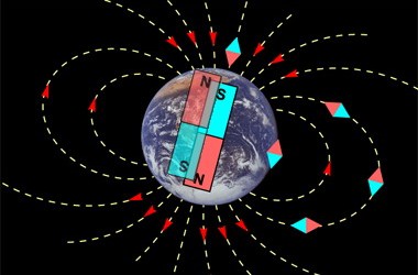
A growing number of scientists are starting to worry that it is the magnetic pole shift that seems to be underway that is the real culprit behind climate change. Not man made air pollution, not the sun, not the underground volcanic activity heating up the oceans, but the slow beginning of a pole shift that has been thought to destroy entire civilizations in the past and be one major factor in mass extinctions. NASA recently discovered and released information about a major breach in the earth's magnetic field.

This breach in the earth/s magnetic field alone, in that it is allowing solar winds to enter the earths atmosphere, is sufficient to really mess up the weather. Not only is this accelerating magnetic pole shift messing up the weather it is having major effects on geopolitics. These magnetic shifts are not only capable of causing massive global super storms, but can cause certain societies, cultures and whole countries to collapse, even go to war with one another.

All yet remains to be seen, but the magnetic reversal of the earth's poles seems to be rapidly increasing and IS affecting world weather patterns. The real question is how bad will things get before it all settles backdown to a "new normal?" At one time in history it was thought the North Pole was in the area that is now known as Hudson Bay. If the Hudson Bay area was the last locatoin of the North Pole, where will it go next? And how bad will global super storms and climate change get before it is over? And can we stop blaming each other for causing this and work together to survive it and keep civilization in tact? (Suite101)

Comment: As was mentioned in the opening comment, here are several snippets from McCanney's work, and as presented in Harrison's Koehli's article Planet-X, Comets and Earth Changes by J.M. McCanney that compare and contrast McCanney's concept of the Earth's magnetic field to the one described in this article.

If you study his work, you will come to the understanding that the 5 layers of the Earth's atmosphere are also layers of alternating electrical charge. McCanney also discusses how these electric flows around and on the earth interact with the sun to create our weather/climate.
McCanney identifies five layers of magnetic field, two permanent and three variable. Earth's central core (the original comet "seed") maintains a permanent magnetic field, formed as it cooled early in Earth's life. Next is the molten layer in the sub-mantle: the area that geologists today believe is the main driver of Earth's magnetic field. In McCanney's model this layer is only a lesser component, and subject to influence from the layers above. To top off this layer, there are localized pockets of iron and nickel in the mantle and outer crust, forming more or less permanent magnetic fields, which (on average) align with the field of the core. Some of these magnetized pockets form such large localized distortions of the Earth's magnetic that compass readings are near useless in these locations. (It should be noted that such regions have also been known for their high frequency of UFO sightings and other anomalous happenings based on the research of John Keel and others.)

The variable layers, starting in the atmosphere going up into space, form the bulk of Earth's magnetic field, even though they are not permanent in structure. These layers include the three current flows in Earth's ionosphere: the three "jet streams" which flow westerly at the equator and easterly at temperate latitudes. Above that are the Van Allen radiation belts, followed by the outer current of solar wind. The alleged "magnetic tail" flowing from the night side of the Earth is actually a comet tail, with electrons flowing out and positive ions in. Solar flares activated by comet discharges alter these variable layers of magnetic field by loading them with excess charge, which can in turn lead to hurricanes, ocean heating (El Nino) and potentially Earth Changes.

It's a rare time that doesn't see hysterical warnings of imminent "Pole Shifts" among pseudo-catastrophists and doomsayers. There's a lot of disinformation being spread about the topic. There are actually two types of pole shifts: physical and magnetic. Both depend on external conditions - they don't "just happen". According to McCanney, magnetic reversals in the variable fields may occur because of electrical interactions, but they are only temporary. The core keeps its true north, to which the total field re-aligns after the period of disturbance is over. Findings of rocks and metals magnetized in the opposite direction are most likely the result of their cooling (and thus developing their permanent magnetic properties), or actual physical rotation, during the time in which the variable fields were off kilter.

Similarly, the passage of a large comet can have gravitational effects (like the Moon has on the tides), causing massive tidal waves to course through the Earth's mantle and oceans, causing chain reactions of earthquakes and volcanoes. Like the eggshell of a spinning egg, this can cause the more solid outer layers of the Earth to shift over the molten layers below. (In Atlantis to Tesla - The Kolbrin Connection, McCanney relates that "true north" used to be inhabited by the region just north of New York and Michigan before such a shift occurred several thousand years ago, i.e. a physical movement of 30-40 degrees.) After the outer layers settle down, they will resume rotating in the direction of the core, which, just as it retains its magnetic field, retains its own direction of rotation. However, such gravitational effects can cause a slight precession of the core's rotation, offsetting true north (i.e., Polaris will no longer be the North Star.)
Also, consider the following from Superluminal Communications dated 31 October 2001:
Q: (L) Now according to these guys who are writing this web page about pole shift, they say it can be predicted where the poles will shift to. Is this in fact the case?
A: No.
Q: (L) Why can't pole shifts be predicted? Can't we know where the new pole will end up?
A: Chaotic function here
Q: (L) Okay, in a pole shift does the lithosphere of the planet slide on the core? (A) No. We have to be very precise. There are three possible things that would come under the name pole shift. Only one of them may come, or two, or three, okay? And these are the following - the axis of rotation with respect to stars is changing, straightening out for instance; this is one thing; while all the rest goes with the axis, the lithosphere and the magnetic field. Second, the axis stays where it is, maybe it shifts a little bit; the lithosphere stays where it is - maybe it wobbles - but the magnetic field changes: for instance reverses. Third, axis stays, magnetic field stays, but the lithosphere is moving. So that's three ways a pole shift can happen. And of course there are things that come together. The most dramatic one which is seen from outside is when the axis of rotation changes. The next dramatic one is probably when the lithosphere changes. And the third of unknown consequences is when the magnetic pole changes, okay? So, we want to have an understanding what will be the main change. (L) Well I guess we ought to ask an even more basic question: are we looking at a pole shift happening? That's starting at the beginning. (A) Alright. (L) In the next ten years. Is a pole shift possible in the next ten years?
A: Yes.
Q: (L) Is a pole shift of the axis...(A) Honey, you ask if the pole shift is possible, of course it's possible. But suppose it's almost zero probability? 'Is it possible' is not the right question. 'Is it going to happen?' That's a question. (L) Okay you ask, carry on. (A) Are we looking at a pole shift during the next ten or so years with a high degree of probability?
A: Yes.
Q: (A) In this concept of pole shift, what would be the main feature of this pole shift, of all those which we were discussing?
A: New axial orientation, and magnetic reversal.
Q: (L) That's fairly dramatic. (A) Alright, now, change of axis or orientation of axis of rotation: can we say we would straighten up, getting almost perpendicular to the ecliptic? Or the other possibility is that it will fall down being almost parallel to the ecliptic. The third is that we'll flip completely by 180 degrees. We know it's highly unpredictable, but can we have a clue from which one is, so to say, dominate?
A: Perpendicularity will be restored.
Q: (A) We know the axis will change dramatically and magnetic reversal will happen. You didn't mention a change or shift of the lithosphere alone. Can we...
A: Lithospheric shift will feature to some extent.
For additional education, read the following articles by Ryan X:
Cyclones, Earthquakes, Volcanoes And Other Electrical Phenomena
Pole Shift? Look to the Skies!
Planetary Alignments and the Solar Capacitor - Things are heatin' up!


Bizarro Earth

Australia - Sink Hole Sucks Away Trees at Inskip Point

SinkHole
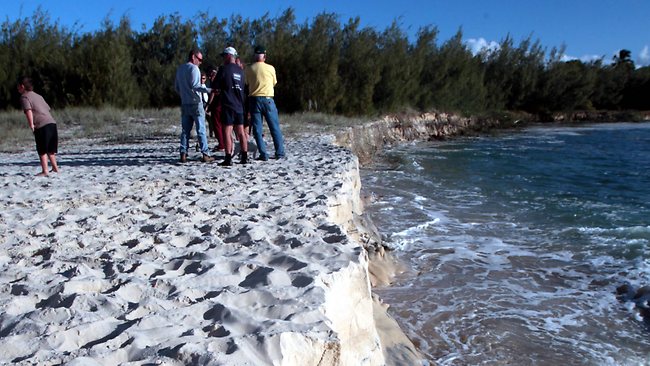
© Glenn Barnes / The Courier-Mail Big Bite: Inskip Peninsula campers cautiously check out the sink hole.
Now you see it, now you don't. That was the case at Inskip beach, north of Tin Can Bay, yesterday as a 100m-wide section of beach was swallowed by a sink hole.

The hole opened up on the popular stretch of beach about 10.30am and by mid-afternoon it looked like a giant bite had been taken out of the coastline.

Campers on Inskip Peninsula watched in awe as chunks of sand were sucked out to sea, followed by trees and signs.
Visitor Rhonda Harris said it was a "phenomenon''.

"When we first came up about 11am the water was actually bubbling like it was boiling,'' she said.

"We saw the 'no camping' sign get washed out.''

Camper Shane Hillhouse said four-wheel drives had been travelling along the popular stretch of sand, near Inskip Peninsula, shortly before the hole appeared.

Bizarro Earth

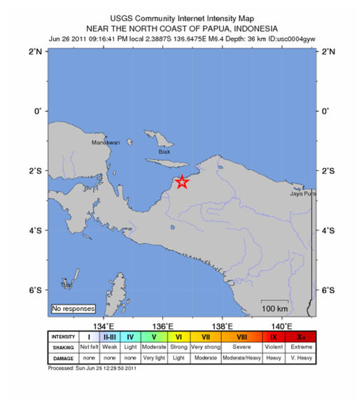
Near The North Coast Of Papua - Earthquake Magnitude 6.4

Papua Quake_260611
© USGSEarthquake Location
Date and Time:
Sunday, June 26, 2011 at 12:16:39 UTC

Sunday, June 26, 2011 at 09:16:39 PM at epicenter

Time of Earthquake in other Time Zones

Location:
2.391°S, 136.663°E

Depth:
20.6 km (12.8 miles)

Region:
NEAR THE NORTH COAST OF PAPUA, INDONESIA

Distances:
172 km (106 miles) N of Enarotali, Papua, Indonesia

331 km (205 miles) ESE of Manokwari, Papua, Indonesia

1286 km (799 miles) NNE of DARWIN, Northern Territory, Australia

3336 km (2072 miles) E of JAKARTA, Java, Indonesia

Phoenix

Firefighters put out 3 forest fires in Russia's Far East in past 24 hours

Image
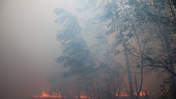
© RIA Novosti. Mikhail FomichevFirefighters put out 3 forest fires in Russia's Far East in past 24 hours
Firefighters and rescuers in Russia's Far East extinguished three forest fires over the past 24 hours and continue battling 11 more forest fires, a spokesman for the regional emergencies ministry said on Sunday.

"Satellite monitoring and aircraft surveillance registered a total of 14 forest fires in the last 24 hours. Three of them covering an area 43 hectares were extinguished," the spokesman said.

He added that the remaining 11 wildfires had spread over the area of 519 hectares.

Radar

China: Magnitude 5.2 Earthquake Hits Yushu, Qinghai Province

An earthquake measuring 5.2 on the Richter scale jolted Nangchen County in the Tibetan autonomous prefecture of Yushu in northwest China's Qinghai Province at 3:48 p.m Sunday, said the China Earthquake Networks Center.

The epicenter was monitored at 32.4 degrees north latitude and 95.9 degrees east longitude with a depth of 10 km, the center said in a statement on its website.

A fresh 3.1-magnitude quake shook the Nangchen county four minutes after the 5.2-magnitude quake, according to the center.

No casualties have been reported so far, said Wen Guodong, vice secretary of the prefectural committee of the Communist Party of China.

"We felt the quake strongly in Nangchen, but near our office we haven't found any collapsed buildings," said Drimi Lhundrup, deputy chief of the county government.

Bizarro Earth

Storm drenches east China while drought plagues northwest

Shanghai - Extreme weather conditions are plaguing China with a strengthening tropical storm on the eastern coastline and a prolonged drought in the northwest.

The full force of Meari, still gaining in strength and likely to soon become a typhoon, would be felt in Zhejiang Province as it makes landfall there Saturday evening, according to an alert from the meteorological station of Zhejiang Province.

Meari, heading northward, is forecast to hit Shanghai soon after, with its center about 150 km to the east and out to sea of the city, according to the Shanghai municipal meteorological station.

Shanghai has emptied reservoirs to make room for the water the typhoon is likely to bring, said Zhang Zhengyu, spokesman for the Shanghai Flood Control Headquarters.