Earth ChangesS


Cloud Lightning

Severe Flooding in Santa Catarina, Brazil

Brazil Flood
© RecreationThe city of Blumenau, in the state of Santa Catarina, southern Brazil.
Ten towns in the state of Santa Catarina in the South of Brazil are in an official state of emergency and a further 25 are on high alert, following several days of heavy rain and flooding. The situation looks likely to get worse, with more rain forecast for the coming days.

According to CIRAM (the Information Centre for Environmental Resources and Hydrometeorology in Santa Catarina), an average of more than 100mm of rain has fallen across the region in the last three days, causing rivers to rise dangerously and provoking landslides in several locations.

Cloud Lightning

'Huge Losses' as Pakistan Floods Kill 200

Pakistan flooding
© AFP/File, A. MajeedSome 5.3 million people have been affected by this year's flooding in Pakistan
More than 200 people have been killed by devastating rains in Pakistan, which is still struggling to rebuild after last year's worst floods in living memory, officials said Monday.

Pakistan, a nuclear-armed state suffering appalling levels of Taliban and Al-Qaeda-linked violence, saw 21 million people affected in the 2010 flooding that killed 1,750 people and cost the economy $10 billion.

Aid agencies have accused the government of failing to invest in adequate prevention measures and vast swathes of farmland have been inundated for a second year in the southern province of Sindh, the nation's breadbasket.

The situation this year was even worse than last year, one official said.

Cloud Lightning

Stormy Weather Across the UK as Remnants of Hurricane Katia Hit

As forecast, a deep area of low pressure which contains post-tropical storm Katia is bringing gales and heavy rain to parts of the UK.


All parts of the UK will see gusty conditions through the start of the week, with the highest wind speeds of 75 to 80 miles per hour expected over northern and western regions of the country.

Calculator

Earthquakes May Make 2011 Second-Costliest Year for Insurers

New Zealand Earthquake
© The Associated Press
Record earthquake losses following the temblors in Japan and New Zealand may make 2011 the second- costliest year in history for insured catastrophe losses, according to Swiss Re Ltd.

Total insured losses from natural catastrophes and man-made disasters reached about $70 billion in the first half of this year, more than double the losses in the same period in 2010, according to estimates by the Zurich-based reinsurer.

The figure was only surpassed in 2005 after hurricanes Katrina, Wilma and Rita caused claims of more than $90 billion, the world's second-biggest reinsurer said. Catastrophe claims usually increase in the second half of the year with the hurricane season in the North Atlantic and typhoons in the northwest Pacific.

Bizarro Earth

Honduran earthquake of 2009 destroyed half of coral reefs of Belizean Barrier Reef lagoon

Image
© Unknown
Earthquake underscores need for conservation planning to take into account infrequent natural disasters

Earth's coral reefs have not been faring well in recent decades, facing multiple threats from pollution, disease, elevated water temperatures, and overfishing. Often referred to as the "rainforests of the Sea," coral reefs support a wide variety of marine life, help protect shorelines, and contribute significantly to tourism and the fishing industry. A new study looks at a rare but catastrophic impact on reefs: the damage caused by natural disasters such as an earthquakes.

In May of 2009, a powerful, magnitude-7.3 earthquake shook the western Caribbean, causing lagoonal reefs in Belize, 213 kilometers (132 miles) from the epicenter, to avalanche and slide into deeper water. As reported in a preprint article of Ecology, a journal of the Ecological Society of America, Richard Aronson of the Florida Institute of Technology and colleagues analyzed data that suggest how the history of the reef will influence its recovery.

During the quarter-century before the earthquake struck, the reefs had gone through mass mortalities of two sequentially dominant coral species. Novel events in their own right, these mass mortalities were instantly "rendered moot" on half the reefs, which were destroyed when the earthquake hit.

Aronson and colleagues' work focused on a 375-square-kilometer (144-square-mile) area of the Belizean Barrier Reef, which they monitored from 1986 to 2009. The group revisited 21 sites in 2010 to determine the impacts of the earthquake. They found that approximately half the reef slopes had slabbed off and slid into deeper water. Only sediment and the skeletal debris of corals remained.
Cloud Lightning

Ireland braced for extreme weather

The UK and Ireland will face extreme weather conditions in the coming days as the tailend of Hurricane Katia sweeps across the Atlantic.

The Met Office has issued a severe weather warning for most of the UK, advising those in the North as well as Scotland, to expect winds of up to 75mph.

Image
© UnknownNorthern Irish motorists have been warned about exposed roads
In Ireland, MET Éireann has also forecast strong southwest winds reaching speeds of 50 to 80 km/hr, gusting 90 to 130 km/hr, with the most severe winds affecting exposed regions of Connacht and Ulster on Monday morning.

X

French diplomat survives shark attack in Papua New Guinea after kite-surfing back to shore for help

A French diplomat working for the European Union has been rushed to Australia for medical treatment after being attacked by a shark in Papua New Guinea.

Thomas Viot, 30, was bitten on the leg by what he believed was a tiger shark as he kite-surfed near a reef off the capital, Port Moresby, 1,000 miles from the northern Australian city of Darwin.

Despite a wound that went down to the bone, causing a huge loss of blood, Mr Viot managed to kite-surf back to a beach where local people and friends rushed to his aid.

Image
© AFP/ Getty ImagesSurvivor: Thomas Viot was bitten on the leg by what he believed was a tiger shark in Papua New Guinea
'I don't know how I managed it after the attack, but somehow I succeeded in riding back to the shore with my kite surf,' he said after being flown to the Queensland city of Brisbane.

Bizarro Earth

Vanuatu - Earthquake Magnitude 6.0

Vanuatu Quake_110911
© USGSEarthquake Location
Date-Time:
Sunday, September 11, 2011 at 23:37:36 UTC

Monday, September 12, 2011 at 10:37:36 AM at epicenter

Time of Earthquake in other Time Zones

Location:
18.186°S, 167.874°E

Depth:
35.1 km (21.8 miles)

Region:
VANUATU

Distances:
63 km (39 miles) SW of PORT-VILA, Efate, Vanuatu

212 km (131 miles) NW of Isangel, Tanna, Vanuatu

298 km (185 miles) SSE of Luganville, Espiritu Santo, Vanuatu

1844 km (1145 miles) ENE of BRISBANE, Queensland, Australia

Bizarro Earth

6.4 quake off Vancouver Island felt by few on Peninsula

Neah Bay - The magnitude-6.4 earthquake centered off the coast of Vancouver Island on Friday afternoon went largely unnoticed on the North Olympic Peninsula.

The 12:41 p.m. quake was centered about 130 miles northwest of Neah Bay at a depth of 14.3 miles, the U.S. Geological Survey said.

"There is no tsunami watch, warning or advisory for the Washington coast," the Clallam County Sheriff's Office said in a statement.

"There have been no reports of anyone from the county who may have felt the earthquake. There are no damage reports from the British Columbia area."

Janine Bowechop, executive director of the Makah Cultural and Research Center in Neah Bay, was working at the museum when the quake occurred.

"I didn't feel a thing," Bowechop said. "But I'm in one of the biggest buildings in town."

Makah Marina Manager Bob Buckingham was at his Neah Bay home during the quake and did not feel the ground shake.

Clallam Bay Fire Chief Patricia Hutson-English did not feel the quake.

"And I haven't heard reports from anyone who felt it," she said.

Karin Ashton, a volunteer at the Clallam Bay-Sekiu Chamber of Commerce visitors center, said: "This is the first I've heard about it."

"We didn't hear a rumble or anything," Ashton said.

"It's been very calm and quiet."

Bizarro Earth

Eastern Caribbean Prepares for Heavy Rain, Winds as Tropical Storm Maria Approaches

Image
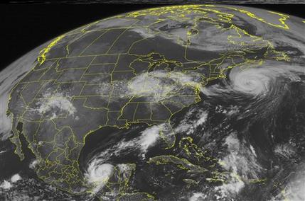
© AP Photo/Weather UndergroundThis NOAA satellite image taken Friday, September 9, 2011 at 1:45 PM EDT shows Hurricane Katia located about 385 miles south-southwest of Halifax, Nova Scotia.
Tropical Storm Maria swirled toward the eastern Caribbean on Friday, threatening to unleash heavy rain and wind on islands still struggling to recover from a recent hurricane.

The storm had maximum sustained winds of 45 mph (75 kph) Friday afternoon, with some slight strengthening possible, said the U.S. National Hurricane Center in Miami. It was centered about 215 miles (345 kilometers) east-southeast of the French Caribbean island of Guadeloupe and moving northwest at about 16 mph (26 kph).

Tropical force winds will start lashing the U.S. Virgin Islands on Saturday morning, where the storm is expected to dump up to 6 inches (15 centimeters) of rain, said Walter Snell with the National Weather Service office in Puerto Rico.

"Residents should be prepared for whatever the worst this storm can do," he said.