Earth ChangesS


Bizarro Earth

An Unusual Phenomenon: Vanishing Arctic Lakes

Polar Bears
© Reuters / IBTimes Staff ReporterResearchers from the University of Copenhagen and the Aarhus University have warned that polar bear species as primary predators are ailing as industrial pollutants get absorbed in the Arctic Ocean food chain.
A new and strange phenomenon is baffling scientists. This is the case of the vanishing lakes in the northern part of the Arctic which can have an impact on local wildlife and human populations, researchers said.

Canada lost some 1.2 percent of its water surface or 6700 square kilometers between 2000 to 2009 as revealed in a satellite survey of the 1.3 million lakes stretching from coast to coast, according to the International Arctic Research Center in Fairbanks, Alaska,

"It's an important finding. We need to find out what's driving it," says Larry Hinzman, director of the research center.

Previous surveys showed that there had been shrinking Arctic lakes, but only in the southern-most part of the Arctic. But the new survey, carried out by Mark Carroll at the University of Maryland in College Park found that the reverse is happening: it is the northern lakes that appears to be shrinking.

Bizarro Earth

Iceland: Earthquake swarm in Tjörnes Fracture Zone

Today (18 October, 2011) at 08:53 UTC a earthquake swarm started in TFZ. So far this earthquake swarm is small in nature, only about dozen earthquakes so far. But the largest earthquakes have been with the size of ML3.6 according to IMO automatic earthquake detection system (called SIL). There is a good chance that this earthquake swarm is going to continue for the next few hours. But it is hard to know that for sure at the moment.

Image
© Iceland Met OfficeThe area with the earthquake activity in Tjörnes Fracture Zone (TFZ).
There are no volcanoes in the area where this earthquake swarm is taking place.

Bizarro Earth

Papua New Guinea - Earthquake Magnitude 6.0

PNG Quake_181011
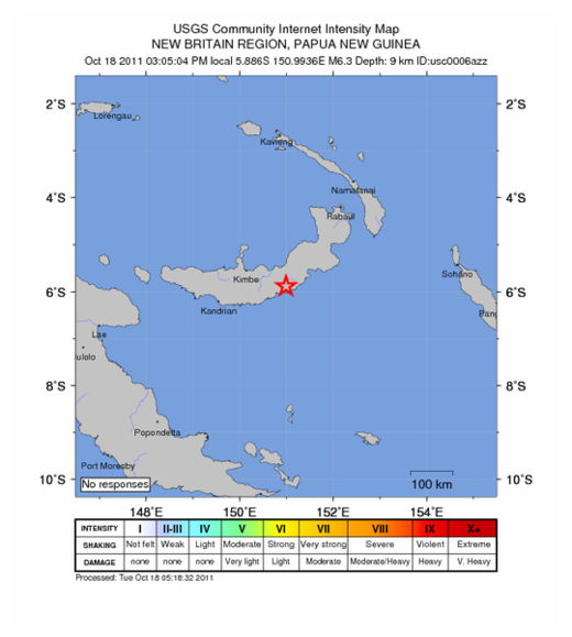
© USGSEarthquake Location
Date-Time:
Tuesday, October 18, 2011 at 05:05:04 UTC

Tuesday, October 18, 2011 at 03:05:04 PM at epicenter

Time of Earthquake in other Time Zones

Location:
5.886°S, 150.994°E

Depth:
9.9 km (6.2 miles)

Region:
NEW BRITAIN REGION, PAPUA NEW GUINEA

Distances:
100 km (62 miles) ESE of Kimbe, New Britain, PNG

163 km (101 miles) ENE of Kandrian, New Britain, PNG

576 km (357 miles) NE of PORT MORESBY, Papua New Guinea

2401 km (1491 miles) N of BRISBANE, Queensland, Australia

Cloud Lightning

US: Dust Storm Roils Through Texas South Plains

Winds gusting at more than 70 mph churned up a dust storm that roiled through the Texas South Plains during the Monday afternoon commute. Dust kicked up by westerly breezes ahead of a strong cold front restricted visibility in Lubbock to about 5 miles all afternoon, said National Weather Service Lubbock meteorologist Matt Ziebell.

That was nothing compared to the 8,000-foot-high rolling dust cloud that moved through the city just before 6 p.m., dropping visibility to between zero and less than a quarter of a mile, Ziebell said. North winds gusting as high as 74 mph had begun forming the dust cloud about 100 miles north of Lubbock around 4:30 p.m., he said.


Attention

Huge Garbage Patch Found in Atlantic

Image
© National Geographic
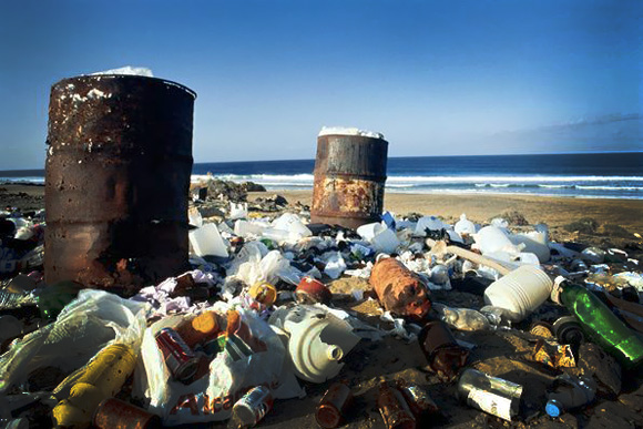
Billions of bits of plastic are accumulating in a massive garbage patch in the Atlantic Ocean - a lesser known cousin to the Texas-size trash vortex in the Pacific, scientists say.

"Many people have heard of the Great Pacific Garbage Patch," said Kara Lavender Law, an oceanographer at the Sea Education Association in Woods Hole, Massachusetts.

"But this issue has essentially been ignored in the Atlantic."

The newly described garbage patch sits hundreds of miles off the North American coast. Although its east-west span is unknown, the patch covers a region between 22 and 38 degrees north latitude- roughly the distance from Cuba to Virginia.

Bizarro Earth

US: New Mexico - Earthquake Magnitude 3.8 Strikes Near Los Alamos Lab

Image
© USGS
A magnitude 3.8 earthquake has struck around 20 miles from Los Alamos National Laboratory.

The U.S. Geological Survey says the light temblor hit after 10:30 a.m. on Monday. It was centered nine miles north of Santa Fe and hit around 19 miles southeast of Los Alamos National Laboratory. It also had a depth of around .7 miles.

There were no immediate reports of damages or injuries.

The small earthquake comes after a magnitude 4.0 earthquake struck northern New Mexico last month and magnitude 5.3 earthquake hit around the same area in August.

Bizarro Earth

US: Earthquake Magnitude 4.0 - Southern California

Image
© USGS
Date-Time:
Monday, October 17, 2011 at 20:05:57 UTC
Monday, October 17, 2011 at 01:05:57 PM at epicenter

Location:
34.697°N, 116.294°W

Depth:
1.8 km (1.1 miles)

Region:
SOUTHERN CALIFORNIA

Distances:
13 km (8 miles) WSW (257°) from Ludlow, CA

40 km (25 miles) WNW (288°) from Bagdad, CA

53 km (33 miles) NNW (340°) from Twentynine Palms Base, CA

64 km (40 miles) N (10°) from Yucca Valley, CA

65 km (41 miles) NNW (342°) from Twentynine Palms, CA

193 km (120 miles) ENE (68°) from Los Angeles Civic Center, CA

Cloud Lightning

Thai PM says floods costs to top $3.3bn, death toll reaches 300

Thailand floods
Three months of heavy rains have deluged about one third of Thailand's provinces
The Thai premier on Monday said reconstruction from massive floods swamping vast swathes of the country is expected to cost the government over $3.3 billion -- a fifth more than previously estimated.

Fears for the capital Bangkok appeared to have eased as authorities battled to contain Thailand's worst flooding in decades, which has claimed over 300 lives, swallowed homes and shut down industry.

But Prime Minister Yingluck Shinawatra warned: "The original budget to support the recovery of both the industrial and agricultural sectors is not likely to be enough."

Cloud Lightning

More cyclones than usual are on the way to Australian coast

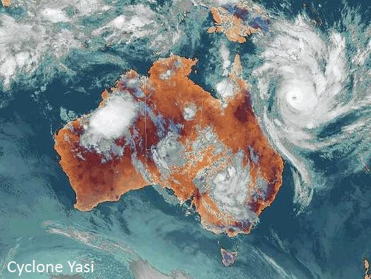
Clyclone Yasi
Cyclone Yasi crossed the coast near Mission Beach, in north Queensland, early on February 3 2010, devastating a number of towns in the region.
Northern Australia is facing another summer of more tropical cyclones than usual less than a year after Yasi - the biggest storm in a century - hit the Queensland coast.

Yasi crossed the coast near Mission Beach, in north Queensland, early on February 3, devastating a number of towns in the region.

The Bureau of Meteorology has warned that although conditions aren't as intense as last season, Northern Australia can still expect an above average number of tropical cyclones in the coming summer.

The bureau is forecasting a La Nina event, which is associated with above average rainfall.

Bizarro Earth

Chilean volcano's ashes ground flights

Image
© APPuyehue-Cordon Caulle volcano
Airline officials say an ash cloud from a recently reawakened volcano in southern Chile has once again forced the cancellation of scores of flights in Argentina, Brazil, Chile and Uruguay.

In statements released Monday, Brazilian airlines Gol and Tam say the cloud from the Puyehue-Cordon Caulle volcano appeared Sunday. The volcano has been sporadically active since June.

The statements indicated that the problem is affecting airports in Rio de Janeiro, Sao Paulo, Buenos Aires, Argentina and Montevideo, Uruguay, and involves both domestic and international flights.