Earth ChangesS


Bizarro Earth

Eastern Turkey - Earthquake Magnitude 7.2

Turkey Quake_231011
© USGSEarthquake Location.
Date-Time:
Sunday, October 23, 2011 at 10:41:21 UTC

Sunday, October 23, 2011 at 01:41:21 PM at epicenter

Time of Earthquake in other Time Zones

Location:
38.628°N, 43.486°E

Depth:
20 km (12.4 miles) set by location program

Region:
EASTERN TURKEY

Distances:
16 km (9 miles) NNE of Van, Turkey

118 km (73 miles) N of Hakkari, Turkey

127 km (78 miles) SSE of Agri (Karakose), Turkey

929 km (577 miles) E of ANKARA, Turkey

Evil Rays

Between 500-1,000 reported dead in massive Turkey earthquake

Image
© ReutersA survivor being carried to the ambulance after an earthquake in Tabanli village near the eastern Turkish city of Van October 23, 2011.
Dozens of buildings collapsed in various cities in the southeast region after 6.6-magnitude quake hit.

Turkey's Kandilli Observatory estimates that some 500 to 1,000 people were killed in a powerful earthquake in southeast Turkey's Van province on Sunday, broadcaster CNN Turk reported.

Separately, Deputy Prime Minister Besir Atalay told reporters some 10 buildings had collapsed in Van city and around 25-30 buildings collapsed in the nearby district of Ercis.

The Turkish Red Crescent reported that 25 apartment buildings and one dormitory in the eastern town of Ercis have collapsed. The Red Crescent says its rescuers have pulled several injured people out of the collapsed dormitory

The magnitude 6.6 earthquake hit near Van in southeastern Turkey on Sunday, Turkey's Kandilli Observatory and Research Institute said.

Phoenix

Experts warn a 'rumbling' Icelandic volcano could disrupt air travel, world economy - again

Image
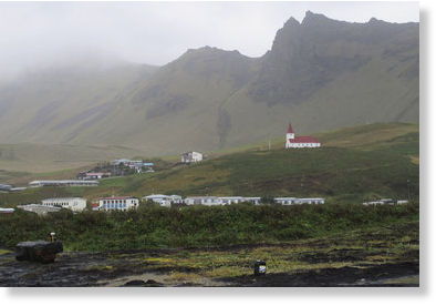
© AP Photo/Paisley DoddsVik, a small Icelandic town of just 300 people, where residents still recall stories from their relatives of Katla volcano's last eruption in 1918, sits under a blanket of cloud in this Sept. 27, 2011 photo. If Iceland's air-traffic paralyzing volcanic eruption in 2011 seemed catastrophic, just wait for the sequel. That's what many experts are saying as they nervously watch rumblings beneath a much more powerful Icelandic volcano - Katla - which could spew an ash cloud dwarfing eruption that cost airlines $2 billion and drove home how vulnerable modern society is to the whims of nature.
Remember when Eyjafjallajökull, that Icelandic volcano with the impossible name, erupted in spring 2010, disrupting air traffic all over the world and costing airlines and the global economy billions?

Child's play, The Associated Press reported over the weekend, if seismic activity from another Icelandic volcano with a history of nasty tantrums leads to an eruption.

Seismologists in Iceland are wary of an increasing number of small, 3- to 4-magnitude earthquakes under the volcano Katla, whose last eruption in 1918 proved deadly.

That eruption produced a noxious cloud that literally blacked out the sun, killing off crops and livestock, the AP reported.

Bizarro Earth

Massive earthquake swarm near Gujarat- Is India on the eve of tearing?

Image
© Wikipedia
An earthquake swarm of more than 41 earthquakes have shaken the region of Gujarat, India on October 21, 2011 following the 5.0 magnitude earthquake which struck the area the day prior at a depth of 15.5 km (9.6 miles). Since that time, the tremors in the region has increased at a frenzied pace- indicating the earthquake may be more than just a random seismic tremor. The Indian Plate is currently moving northeast at 5 cm/yr (2 in/yr), while the Eurasian Plate is moving north at only 2 cm/yr (0.8 in/yr). This is causing the Eurasian Plate to deform and the India Plate to compress at a rate of about 4 mm/yr (0.15 in/yr).

The compression fold forming the Himalaya Mountains along the Tibetan plateau forms the base-line for the Alpide Belt which, as we mentioned earlier, is showing increased signs of stress. Volcanism and ongoing seismic activity is also being reported in the Karachi region which sits as a buttress between the countries of Pakistan and India. (Above) Encircled areas on the map include major tension points in the country.

Bizarro Earth

On the brink: Tremors increase at Anak Krakatau to 5,000 a day

Several earthquakes have struck near south Sumatra of the 5.0 and 5.1 magnitude range today- making a tense situation on the volcanically-dotted archipelago potentially even more volatile. The Anak Krakatau volcano is showing signs of increased seismic activity. Authorities fear the volcano is building towards an eruption that could dwarf the one which occurred in 2007.

Image
© Unknown
Indonesia's Volcanology and Geological Disasters Mitigation Center reported the numbers of seismic tremors now registering from the volcano have exceeded 5,000 a day. There are also reports of a gaseous mist which has seeped from the volcano and have enshrouded it in a yellowish haze- something that has never been observed at the volcano before. Anak Krakatau was placed on orange (level 3) status alert on September 30, 2011.

Bizarro Earth

US: Fault cavity found near Marianna, Arkansas indicate region can produce 7+ magnitude earthquakes

Researchers have found new evidence of earthquakes in the Mid-South. They say the quakes could be the result of a new fault line, a little sister, or big sister, of the New Madrid.

"It's opened up to ancient history down here," geophysicist Rob Williams tells abc24.com as he looks down into a pit made to study evidence of earthquakes in Marianna, Arkansas. "We're looking back 4,000 to 10,000 years down in this pit," he says. The pit may seem like a simple hole in the ground, but to Williams it's much more.

"What this shows," he says, "is that we've had at least two large earthquakes in the last 10,000 years about as big as the New Madrid earthquakes of 1811 and 1812." Williams tells abc24.com those earthquakes were huge. "Magnitude seven plus," he says, "but probably less than an 8."

Image
© USGS

Evil Rays

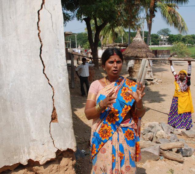
India: Mild tremors felt in Nalgonda villages

Image
© The HinduTremor hit villagers of Puttamgandi tanda in Nalgonda district. Photo: Singam Venkataramana
Mild tremors, lasting two to three seconds, enough to result in the walls of a few houses developing cracks, occurred in over ten villages and Girijan areas of Piyepalli mandal, about 100 km from here, in the small hours of Thursday.

The villages are surrounded by hills. The Puttangandi irrigation project, which is also a source of drinking water, is nearby.

Bizarro Earth

Trio of US Quakes Includes Largest Ever Recorded in Texas

US Quakes
© USGS
Over the past 48 hours, small earthquakes have rocked various parts of the United States, including the largest ever recorded in Texas by the United States Geological Survey. The quakes, in San Francisco, San Antonio and Hawaii, are unrelated, seismologists said.

No casualties have been reported after the quakes.

"We have lots of earthquakes; it's common, really nothing out of the ordinary. None of the quakes are very big," said Paul Caruso, a geophysicist at the National Earthquake Information Center. "They are totally separate faults and in no way related at all."

A 4.8 magnitude earthquake hit southern Texas, about 47 miles (76 kilometers) outside San Antonio, at 7:24 a.m. local time (8:24 a.m. EDT) yesterday (Oct. 20). The epicenter of the quake was close to Fashing, Texas, a natural gas and oil mining town.

Bizarro Earth

Kermadec Islands Region - Earthquake Magnitude 7.4

Kermadec Quake_211011
© USGSEarthquake Location
Date-Time:
Friday, October 21, 2011 at 17:57:17 UTC

Saturday, October 22, 2011 at 05:57:17 AM at epicenter

Location:
28.941°S, 176.046°W

Depth:
39.8 km (24.7 miles)

Region:
KERMADEC ISLANDS REGION

Distances:
180 km (112 miles) E (79°) from Raoul Island, Kermadec Islands

870 km (541 miles) S (185°) from NUKU'ALOFA, Tonga

2978 km (1851 miles) WSW (240°) from PAPEETE, Tahiti, French Polynesia

Bizarro Earth

Thailand Prime Mininister assumes emergency powers as scope of flooding disaster widens

Image
© Surapol Promsaka na SakolnakornPrime minister Yingluck Shinawatra answers reporters' questions at Flood Relief Operations Command (Froc) at Don Mueang Airport.
Prime Minister Yingluck Shinawatra on Friday assumed powers under the natural disaster law giving her full authority to implement a nationwide disaster relief plan.

Invoking the provisions of the Disaster Prevention and Mitigation Act (2007) gives the prime minister full authority over state officials around the country. Those who refuse to follow orders can be prosecuted for negligence of duty. The prime minister becomes director of the relief operation.

Ms Yingluck said the move was necessary to streamline relief operations.

She has ordered the Defence Ministry and the army to oversee and protect key places including the Grand Palace, other palaces, Siriraj Hospital, flood barrier lines, utilities providers, and Suvarnabhumi and Don Mueang airports.

The government has struggled to channel the massive amount of water that has caused widespread flooding in the country's Central Plains, around the outskirts of Bangkok.